


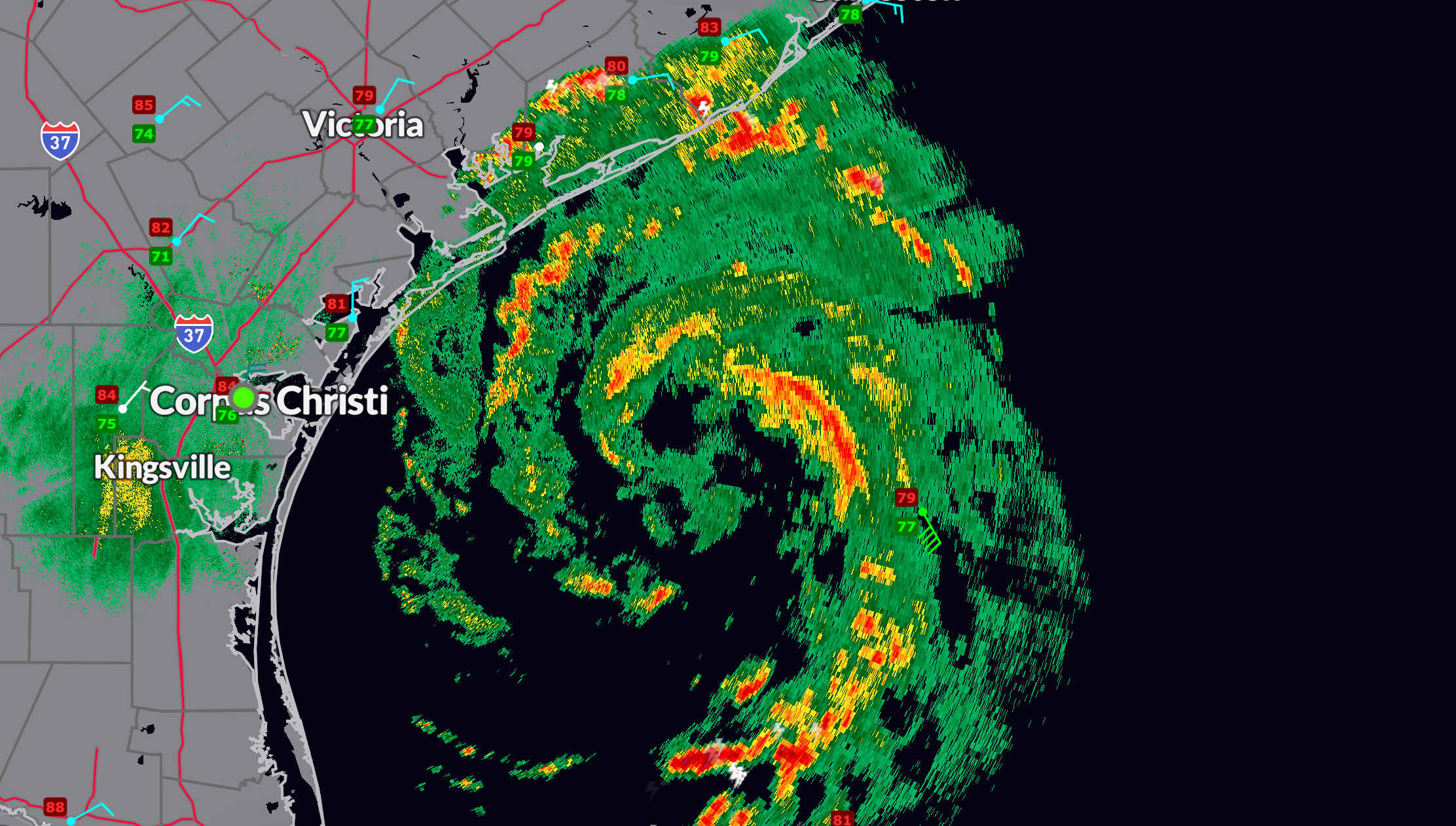
FAST FACTS AT 10 PM
———————————————–
LOCATION…27.6N 95.6W
ABOUT 75 MI…120 KM SSE OF MATAGORDA TEXAS
ABOUT 110 MI…180 KM E OF CORPUS CHRISTI TEXAS
MAXIMUM SUSTAINED WINDS…70 MPH…110 KM/H
PRESENT MOVEMENT…NNW OR 345 DEGREES AT 10 MPH…17 KM/H
MINIMUM CENTRAL PRESSURE…986 MB…29.12 INCHES
As of 10 p.m CDT, Tropical Storm Beryl is gradually getting better organized but is still a tropical storm. The NOAA plane found a lower pressure of 984.2 millibars. The NHC adjusted it to 986. The Air Force plane found several flight level winds to strong tropical storm force in the eastern semicircle, but the max adjusted wind to the surface was 68 mph. Satellite and radar imagery, along with reconnaissance aircraft reports, indicate that an eyewall is forming on the northern and eastern sides of the storm. However, dry air intrusion on the southern and southwestern sides is expected to slow down any rapid intensification. Beryl is currently moving nearly due north, altering its expected landfall to somewhere near Freeport and Surfside Beach, Texas.
WIND
Beryl is projected to strengthen overnight and could reach the threshold between a Category 1 and Category 2 hurricane, with winds of 90-100 mph by landfall, expected between 4 am and 5 am CDT Monday. Areas from Freeport and Surfside Beach to Galveston Island and High Island are likely to experience hurricane conditions with wind gusts up to 100 mph. Further inland, locations including Alvin, Pearland, Houston, and The Woodlands should also prepare for elevated wind impacts. Winds just gusted to 30 mph here at Port Lavaca and 39 mph at Palacios.
STORM SURGE
A storm surge of 5 to 8 feet is anticipated around Galveston, Galveston Bay, and the Houston Ship Channel. Further down the coast, from Matagorda Bay to Corpus Christi, tropical storm conditions are expected, including a storm surge of 2 to 4 feet and rainfall totals of 1 to 3 inches. Up the coast, areas around Port Arthur, Sabine Pass, Lake Charles, and Cameron may also experience tropical storm conditions, a storm surge of 2 to 4 feet, and rainfall totals of 2 to 5 inches on Monday.
RIP CURRENTS
Dangerous rip currents and hazardous coastal conditions will persist along the Texas coast and adjacent areas over to Florida through at least Monday.
RAINFALL FLOODING/TORNADOES
Significant rainfall is expected, with totals of 6 to 10 inches from Sunday night through Monday. This will lead to flash flood concerns across the affected regions. Further inland, heavy rain and flash flooding are likely across areas east of I-35, extending into North and Northeast Texas, including areas east of Dallas. Additionally, wind gusts of 50-60 mph are expected as far inland as I-20 during Monday and Monday night.



