


Daily Weather Briefing
Saturday, May 30, 2026
ALABAMA THIS MORNING
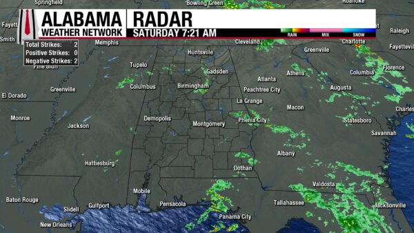
Clouds blanket the state this humid Saturday morning. Temperatures sit in the low 70s across most of the state, with south Alabama reaching the mid 70s. Gulf Shores is leading the race, already reading 79 degrees! Dewpoints sit close to or at these temperatures, and patchy fog can be expected across the state. Additionally, a few light showers spread over the state this morning. Showers fall near Lynn and south of Haleyville. Rain also falls over Pell City, New London, Harpersville, and Inverness. To the south, showers impact Auburn, Smiths Station, and Crawford. In the southeast corner of Alabama, light showers rinse Bertha, Capps, Haleburg, Taylor, and Cottonwood. Over the past 12 hours, Huntsville has received 1.04” of rain, Birmingham saw 0.09”, Auburn measured 0.56”, Eufaula 0.28”, and Dothan 0.09”.
ALABAMA 7 DAY FORECAST
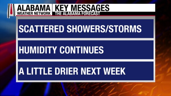
Spotty showers and thunderstorms today will be driven by the fact that we are wedged between an upper-level ridge to our west and an upper-level trough to our east. Tomorrow, showers and thunderstorms become more widespread as the stationary front that currently sits in the northeast will slowly move southward. Thunderstorm chances dwindle in the northern half of the state starting Monday as drier air behind the boundary filters into the state. The southern half of the state does not see such an early start to the new pattern, as the boundary will linger in the area before a cold front pushes through the entire state on Tuesday. Rain chances increase starting again on Thursday, and another wet pattern is expected to end the week.
SPOTTY THUNDERSTORMS TODAY
The upper-level ridge will cause showers and thunderstorms to develop in a spotty pattern today, so widespread showers are not expected. Despite their fragmented nature, storms will be efficient rain producers and cause heavy downpours. Additionally, frequent lightning and strong winds are possible. This trend applies to the entire state today. Skies will be mostly cloudy, but sunshine could peak through here and there. Highs will climb into the low to mid 80s from north to south-central Alabama, while the south sits in the upper 80s. Southwest cities like Mobile and Chatom will flirt with 90 degrees today. These warm temperatures will feel warmer since our air is so moist. Heat index values could climb into the upper 80s in the north and the lower 90s in the south. Carry an umbrella on you, and if you’re spending prolonged time outside today, keep an eye on the sky and stay hydrated.
WETTER SUNDAY
Showers and thunderstorms will form Sunday afternoon and will be more scattered to widespread than what we’re expecting today. Again, storms will be capable of producing quick downpours, lightning, and strong winds. Highs will climb into the low to mid 80s north, the mid 80s centrally, and the upper 80s to lower 90s in the south. On the eastern border, highs may stay a few degrees below their counterparts in their region, as cooler air from the east will be filtered into the region. Otherwise, the focus again turns to the heat index, especially in the south. Moist air and already warm temperatures will mix to produce heat index values (feels like temperatures) in the low to mid 90s, even brushing the upper 90s. Practice heat safety, stay hydrated, and find ways to cool down if you find yourself outside this weekend.
DRYING NORTH, STILL WET SOUTH ON MONDAY
Behind the boundary, drier air will move into the state on Monday. Rain chances in the northern half of the state drop to 20%. Meanwhile, in the southern half of the state, showers and thunderstorms will continue as the boundary sits over the area. Highs will climb into the mid 80s north, and the upper 80s to lower 90s in central and south Alabama. Another day of keeping an eye on those heat index values in the south is in store.
BRIEF DRY PATTERN THROUGH WEDNESDAY
A cold front is expected to push through the state on Tuesday, bringing much drier air to the entire state. Rain chances will only be 20% statewide. Showers will develop in a summer-like pattern: quick afternoon thunderstorms with little coverage. Highs on Tuesday will sit in the low to mid 80s in the north, the mid to upper 80s centrally, and the upper 80s and lower 90s in the south.
A 20% chance of showers lingers on Wednesday, and highs will be in the low to mid 80s from north to south.
RAIN CHANCES INCREASE TO END THE WEEK
The dry air will be pushed out of the state quickly by Thursday, and a rainier pattern starts again at the end of the week. Rain chances stay around 20% in the north but jump to 40% in the south. Highs will be in the low 80s statewide.
Thunderstorm chances increase further on Friday, hitting 30% for the northern half of the state and 60% in the southern half. Highs will budge little from Thursday’s.
RAINFALL OUTLOOK
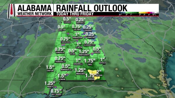
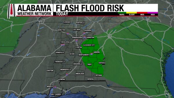
Only eastern portions of central/south-central Alabama are under a Marginal Risk (¼) for Excessive Rainfall today. Otherwise, the flash flood risk has decreased largely across the state. Over the next 7 days, 0.25 to 2” of rain is expected to fall over Alabama. The larger concentrations of rain are anticipated in the south as the frontal boundary keeps rain chances elevated through much of the forecast period.
WET PATTERN IMPROVES DROUGHT
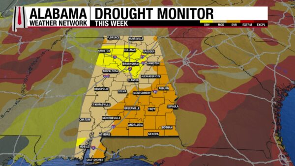
The downpours we’ve seen over the past week or so have greatly improved Alabama’s statewide drought conditions. Last week, 12.90% of the state was in an Extreme Drought (D3). This week, no part of the state is experiencing Extreme Drought conditions! Almost half of the Severe Drought (D2) category has shrunk across the state as well. The Abnormally Dry (D0) category has grown, indicating that Moderate Drought Conditions (D1) are improving, although that area has increased somewhat as Severe Drought weakens. Overall, a decent dent has been made in improving the drought Spring brought, but a lot more work is to be done.
DRY PATTERN BEGINS ON COAST
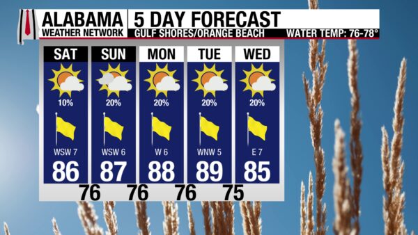
After a few weeks of high rain chances on the coast, thunderstorm chances only reach 20% this week. Today features a 10% chance of showers, likely to form in the afternoon, if at all. Skies will be mostly sunny, the UV Index will be Very High, and the high will be around 86 degrees. There will be a nice breeze as winds come from the southwest at 10 mph. The waters are calm today as well, with the rip current risk falling to Moderate after a stretch of High days. Caution should still be exercised in the water, as rip currents are still possible and dangerous. The surf height is around 2 to 3 feet.
TODAY IN WEATHER HISTORY
May 30, 1879 – The Man Who Knew
On May 30, 1879, a devastating tornado outbreak swept across portions of Kansas and the central Plains, leaving shattered towns, destroyed farms, and stunned survivors in its wake. Among the hardest-hit communities was Irving, KS, where two tornadoes struck within just forty-five minutes, destroying much of the town. Another violent tornado struck near Delphos, KS, part of a larger outbreak that produced more than a dozen major tornadoes across the region.
At the time, tornadoes remained deeply mysterious and poorly understood. Most Americans viewed them as random acts of nature that arrived without warning and vanished just as suddenly. There was little organized research into tornado behavior, no forecasting system, and virtually no scientific understanding of why certain weather patterns produced violent storms while others did not.
But one man was paying close attention.
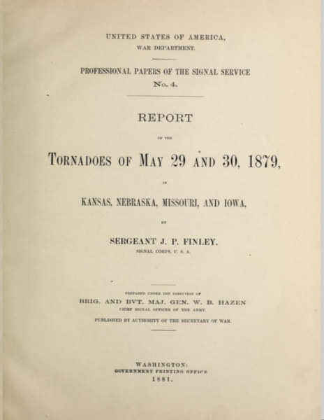
John Park Finley, a young officer with the U.S. Army Signal Corps, had recently been tasked with studying tornadoes across the Plains and Midwest. Unlike many scientists of the era who dismissed tornadoes as impossible to predict, Finley believed patterns existed within the chaos. The 1879 outbreak became one of the major events he carefully documented as he traveled through damaged communities collecting eyewitness accounts, mapping paths, recording storm behavior, and cataloging destruction.
In Irving, survivors described terrifying scenes as the first tornado tore through town before a second storm arrived less than an hour later. Homes collapsed into piles of timber, businesses were destroyed, and debris littered the countryside for miles. In Delphos, the violent F4 tornado swept across rural Kansas with devastating force, leveling structures and leaving entire farms unrecognizable. These storms became crucial case studies for Finley’s growing tornado research archive.
Not everyone appreciated his efforts.
A local newspaper openly mocked Finley’s investigations, arguing that studying tornadoes would provide little comfort to those who had survived the storms and little protection to future generations. That skepticism reflected a broader attitude across much of the country. Many people viewed tornadoes as too unpredictable to study scientifically, and some within the Signal Corps itself questioned whether Finley’s work had practical value.
Yet Finley pressed forward. He established one of America’s first organized networks of volunteer tornado observers across tornado-prone regions of the Plains and Midwest. He developed early theories about atmospheric conditions favorable for tornado formation and compiled one of the first large tornado climatologies in the United States. Most remarkably, he even began issuing experimental tornado forecasts decades before tornado forecasting became officially accepted in America.
But Finley’s work collided with politics and internal struggles within the Signal Corps weather service. Some superiors disliked the public use of the word “tornado,” fearing forecasts would create panic. Others resisted Finley’s growing influence and questioned his methods. Eventually, despite years of groundbreaking research, Finley was reassigned to other duties, and much of his work faded into obscurity for decades.
Still, modern meteorology eventually caught up to what Finley had recognized long before most others: tornadoes were not random mysteries beyond study. Today’s severe weather forecasting systems — from tornado watches to radar warnings and storm spotter networks — all carry traces of the foundation he helped build after outbreaks like the one that devastated Kansas in May 1879.
IMAGE(S) OF THE DAY
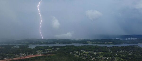
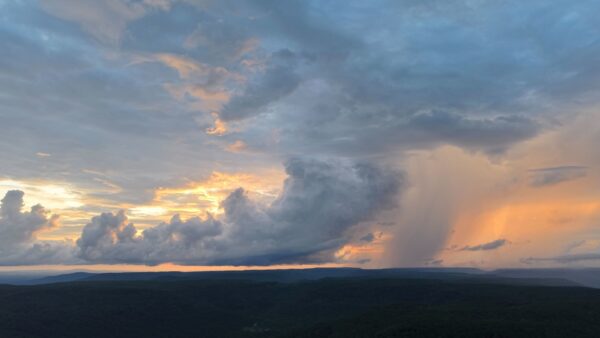
Skywatcher Daniel Harbin was busy operating his drone yesterday and captured these two incredible pictures from yesterday’s storms!
1. Lightning from storms in Scottsboro
2. Rain shaft from the storm in Scottsboro
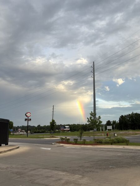
Skywatcher Grayson Harrison also sent in a picture yesterday. A bright rainbow formed in Chelsea!



