


Daily Weather Briefing
Tuesday, July 28, 2026
ALABAMA THIS MORNING
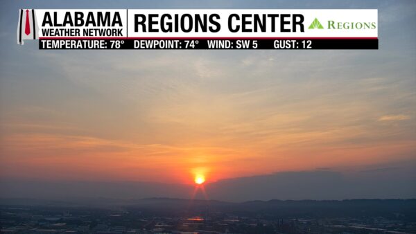
It’s a warm and unpleasantly muggy morning across Alabama with temperatures sitting in the 70s. Dewpoints sit right there with them in the low to mid 70s. Skies are mostly clear in the northern half of the state, while patches of clouds and clear sky alternate in the southern half. Our Regions Center Skycam in Birmingham captures the sun as it begins to rise over the city this morning.
ALABAMA 7 DAY FORECAST
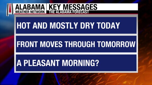
Today will be the hottest day of the week and mostly dry as the upper-level ridge to the west has its strongest hold on the state. To our east, an upper-level trough will dig further into the Eastern United States today and tomorrow, sending a cold front through Alabama Tuesday evening through Wednesday. This will bring higher rain chances and cooler temperatures to the state tomorrow. Thursday and Friday will be on the drier side in the northern two-thirds of the state while a few showers will be possible in the south, but overall Alabama will not be as hot. Rain chances increase into the weekend and Monday as we continue to feel the relief of slightly cooler temperatures.
HOTTEST DAY OF THE WEEK TODAY – July 28
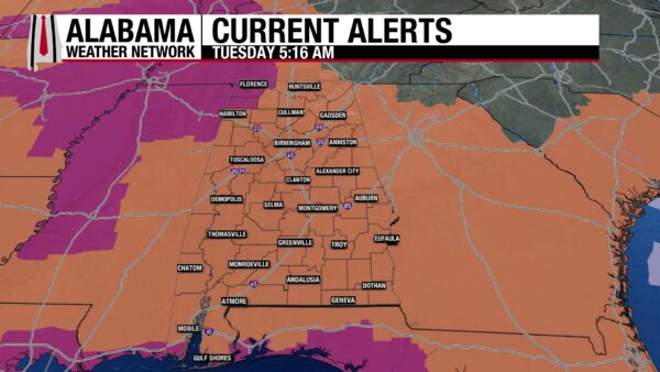
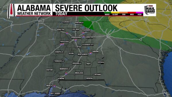
Today will be the hottest day of the week with highs climbing into the upper 90s statewide. A few locations could easily hit 100 degrees. And with very moist air evident by our dewpoints in the upper 70s and low 80s, feels-like temperatures will sit in the 105-115-degree range across the state. A heat advisory is in effect for most of Alabama through the evening, meaning feels-like temperatures will be in the 105-109-degree range, while Lauderdale, Colbert, Franklin, southernmost Mobile, and some of Baldwin Counties will see feels-like temperatures from 110-112 (northern counties) to up to 115 degrees (southern counties)! A stray shower or two is possible in the south today, but the state as a whole can expect a partly cloudy and hot day. After the sun goes down, specifically from 9 p.m. to 12 a.m., a few showers and thunderstorms could clip north Alabama, and the northeast corner of the state has a low chance of seeing severe thunderstorms that produce damaging winds, frequent lightning, and heavy downpours. So, the Storm Prediction Center has placed the region under a Marginal (1/5) Risk of Severe Thunderstorms.
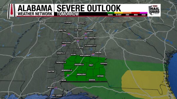
FRONTAL PASSAGE TOMORROW – July 29
Beginning later this evening, a cold front will begin to push through Alabama. Showers and thunderstorms follow behind it and will reach Alabama by Wednesday morning. Throughout the first half of the day, the northern half of the state will see scattered to numerous showers and thunderstorms that will push into the southern half of the state in the second half of the day, but a few storms could still linger in central Alabama in the afternoon. As the storms reach south Alabama, they have a low chance of becoming severe, especially to the southeast. The Storm Prediction Center has placed southeast Alabama under a Marginal (1/5) Risk of Severe Thunderstorms for tomorrow afternoon. Any severe storms that develop will be capable of producing damaging winds, frequent lightning, and heavy downpours. The rain will keep the northern half of the state much cooler than the first half of this week, with highs only rising to the low to mid 90s. South Alabama will still be hot, but more mid-90-degree readings will stretch across the region than upper 90-degree readings.
DRIER THURSDAY AND FRIDAY – July 30-31
The cold front will bring a decent swath of drier air to Alabama. Although highs will be in the upper 80s and low 90s across the state on Thursday, dew points will have found their way into the 60s and low 70s, making our usually sticky air feel much less oppressive. A similar setup is expected Friday. Both days will be mostly dry, but the frontal boundary may hang out around south Alabama through Thursday, keeping the chance for an isolated afternoon thunderstorm low, but not zero.
RAIN RETURNS THIS WEEKEND AND NEXT WEEK – Aug 1-3
We’ll be watching a low-pressure system to the northwest that could push its frontal boundary through Alabama this weekend, bringing scattered rain chances back to the state. We will also be cooler statewide, with the mid to upper 80s expected for highs each day. If you’re tired of the heat, relief is on the way!
RAINFALL OUTLOOK
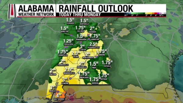
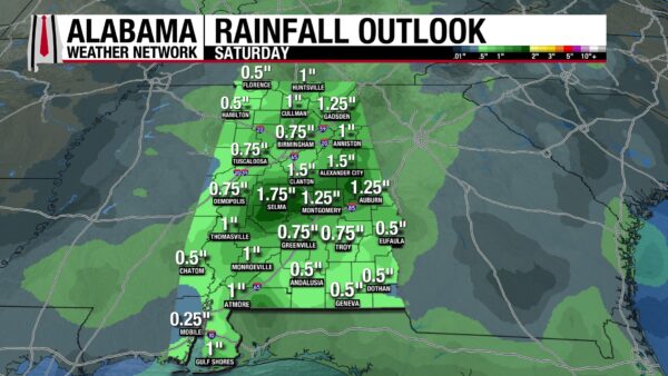
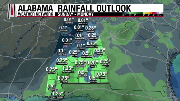
Over the next seven days, Alabama could see anywhere from an inch and a half to 3, maybe 4 inches of rain. A lot of this rain is expected to fall this weekend, with Saturday alone anticipating that the entire state will measure around half an inch to almost 2 inches of rain, and Sunday and Monday expecting another half an inch to almost an inch and a half in the south. Before this weekend, however, tomorrow’s front brings a low risk (Marginal (¼) Risk) for Flash Flooding to the south as thunderstorms will be able to produce heavy downpours.
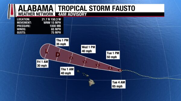
FAUSTO AND GENEVIEVE IN THE PACIFIC
Fausto has weakened to tropical storm status and is now east-northeast of Hawaii with sustained winds of 65 mph and a central pressure of 1000 mb. It is moving west-northwest at 15 mph and will stay north of Hawaii as it passes the state this week. It is forecast to keep its tropical storm strength until Thursday morning. Hawaii stays in the clear from most impacts, but large and rough surf will continue throughout the week.
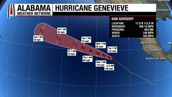
Hurricane Genevieve is still a powerful Category 4 hurricane with sustained winds of 140 mph and a central pressure of 943 mb located closer (but still quite far) from the Mexican Pacific Coast. As it moves northwest at 10 mph today, it will weaken, and by tomorrow morning it will be a Category 2 storm. Besides rough surf on the Mexican coast, no land impacts are expected.
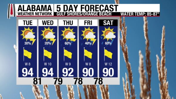
TODAY IS THE BEST BEACH DAY OF THE WEEK
Because it will be so hot today, and because the rain chance is on the lower end today, it looks to be the best day of the week to enjoy the beach, especially in the water. Today’s high will be in the mid 90s, the feels-like temperature could hit around 110-115 degrees, and the winds from the west at 10 mph will provide a breeze to relieve at least a little bit of that heat. Skies will be mostly sunny, and the UV Index will be Extreme (wear and reapply sunscreen!), and besides a quick afternoon thunderstorm, there will be little to interrupt a good beach day. The water will be perfect to cool off in, with a Low rip current risk and a surf height of 1 to 2 feet. Although similar weather conditions are expected tomorrow, the water will get rougher with a Moderate rip current risk. The end of the week sees a higher rain chance, especially Thursday and Saturday.
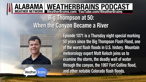
WEATHERBRAINS 1071
Yesterday’s episode features Mountain meteorology expert Matt Kelsh to talk about the 50th anniversary of the Big Thompson Flash Flood. The episode was recorded Thursday as James Spann takes a vacation this week. Listen wherever you get your podcasts or watch the episode here.
TODAY IN WEATHER HISTORY
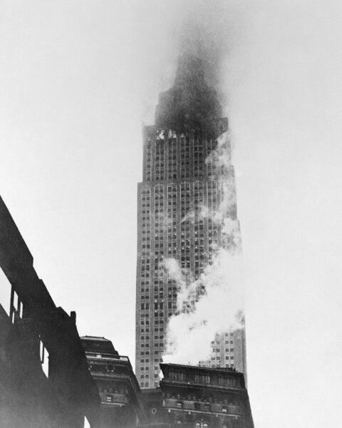
July 28, 1945 – Empire in the Fog
On July 28, 1945, New York City woke up under thick fog and low clouds. World War II was nearly over, with victory already secured in Europe and the Pacific war nearing its final weeks. But on that Saturday morning, the danger over Manhattan came not from an enemy attack, but from weather, visibility and a routine military flight gone terribly wrong.
Lt. Col. William Franklin Smith Jr. was piloting a U.S. Army Air Forces B-25 Mitchell bomber from Bedford Army Air Field in Massachusetts toward New York. The flight was a personnel transport mission, and Smith was trying to reach the New York area before continuing toward Newark. Fog had reduced visibility badly, and the tops of Manhattan’s tallest buildings were hidden in the clouds.
During his descent, Smith dropped below the cloud deck looking for landmarks over Manhattan. Instead, he found himself among the skyscrapers. The bomber moved through the canyons of Midtown, narrowly missing some buildings before striking the north side of the Empire State Building near the 79th floor.
The crash tore an 18-by-20-foot hole in what was then the tallest building in the world. Fuel, metal, and fire ripped through the upper floors. One engine passed through the building and landed across the street, while another plunged down an elevator shaft. Debris fell into the streets below, and many New Yorkers, still living in wartime, feared the city was under attack.
The toll was severe. The 3 plane crewmen died, along with 11 people inside the building. Several others were injured. One of the most remarkable survivals belonged to elevator operator Betty Lou Oliver, who survived a 75-floor plunge after crash damage weakened the elevator system.
The Empire State Building did not collapse, and firefighters brought the fires under control, but the accident became one of the strangest and most dramatic aviation disasters in New York City history. It was a reminder that fog does not have to be violent to be deadly. The crash had many New Yorkers fear a wartime attack and reminded us why low-visibility flight is so dangerous.

IMAGE OF THE DAY
Skywatcher Jonathan Aplin sent in this cool photo of crepuscular rays behind a cloud in Hope Hull yesterday.



