


Daily Weather Briefing
Friday, July 31, 2026
ALABAMA THIS MORNING
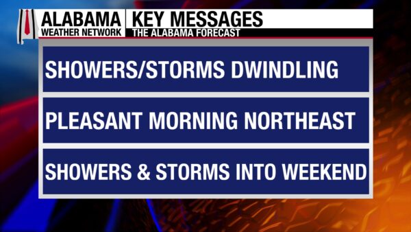
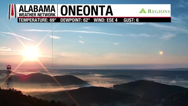
North Alabama is experiencing a pleasant morning, with the southern two-thirds of the state still on the muggier side. Temperatures in the north sit in the mid 60s, as do the dewpoints, making for a saturated but cool morning for the region. Meanwhile, central and south Alabama sit in the low to mid 70s, as do the dewpoints, and muggy. Skies are partly to mostly cloudy, and the Oneonta Regions Skycam view is outstanding!
ALABAMA 7 DAY FORECAST
Today, the northern two-thirds of the state will enjoy one more dry day, while south Alabama can expect scattered afternoon thunderstorms. The entire state has finally been released from the oppressive summer heat, and highs and feels-like temperatures will be normal for this time of year. Tomorrow, a low-pressure system will push east to our north, and its associated cold front will push through Alabama, bringing widespread showers and thunderstorms that have a low chance of becoming severe. Rain chances won’t be quite as high Sunday through Wednesday, but they will still be elevated as the low and subsequent upper-level trough hang out over the Eastern U.S. through the period, keeping moisture elevated. Then toward the second half of next week, rain chances begin to decrease, and highs begin to increase as an upper-level ridge from the west nudges into the region.
DRY AGAIN NORTH, WET AFTERNOON SOUTH – July 31
Today’s weather will be similar to yesterday’s. The northern two-thirds of the state still sits in the pocket of drier air from Wednesday’s front, so showers and thunderstorms are not expected. Cloud cover will be increased compared to yesterday due to the approaching front, but highs will still reach the low 90s. The southern half of the state will see afternoon showers and thunderstorms like yesterday as the stalled front lifts north, but there is no outlook for severe weather. A strong thunderstorm that produces strong winds, frequent lightning, and heavy rain is still possible. Highs will be limited to the lower 90s. Highs will be less hot, which will make feels-like temperatures less hot, and they will reach the mid 90s to around 100 degrees.
COLD FRONT SATURDAY BRINGS THUNDERSTORMS – Aug 1
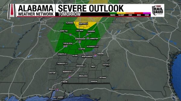
We start the new month off with active weather. The approaching cold front will push through Alabama tomorrow, bringing widespread showers and thunderstorms. With these storms, the northern half of the state is outlooked for a Marginal Risk (1/5) of Severe Thunderstorms. Additionally, Limestone, Madison, Jackson, east Lauderdale, northeast Lawrence, north Morgan, and north Marshall Counties have a Slight Risk (2/5) of Severe Thunderstorms. Any severe storms that develop could produce strong winds, frequent lightning, and heavy downpours. Storms will still be widespread in the south, but they will lack the same ability to become severe. Now, despite the widespread coverage of the storms, tomorrow will not be a complete washout across Alabama. Timing for north Alabama seems to be from 6 or 7 a.m. to 3 p.m., central Alabama: 7 a.m. to 5 or 6 p.m., south Alabama: 7 a.m. to 8 p.m. There will be breaks in the rain, and timing is loose and subject to change. If you have outdoor plans tomorrow, make sure to be weather aware and pay attention to the Alabama Weather Network App for storm notifications and easy access to the radar. After that round of storms pushes through, another comes behind it Saturday night with the actual front. The same impacts are expected. Highs on Saturday will be limited to the low 90s west, upper 80s in the central third of the state (from north to south) and the mid 80s in the east.
SUNDAY THROUGH WEDNESDAY HAVE RAIN AND “COOL” TEMPS – Aug 2-5
After the frontal passage Saturday, medium rain chances will be in the forecast through Wednesday. This is due to the low-pressure system hanging out over the eastern U.S., keeping moisture elevated and available. This will also encourage more clouds, and highs will be below average for this time of year. The upper 80s are expected on Sunday; Monday will see the mid to upper 80s, Tuesday will range from the upper 80s to lower 90s, then the low 90s return on Wednesday, with a few locations holding onto the upper 80s.
TRENDING DRIER TO END THE WEEK – Aug 6
The upper-level trough associated with the low-pressure system will be nudged out of the Southeast by an upper-level ridge to the west. It will decrease rain chances and increase highs into the low 90s statewide.
RAINFALL OUTLOOK
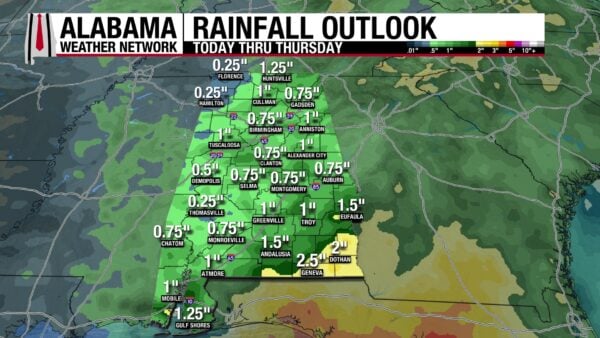
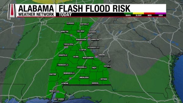
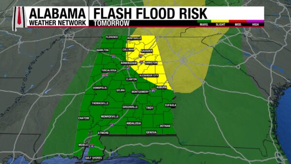
Most of Alabama can expect three-quarters of an inch to an inch of rain through Thursday. Northwest Alabama could see a bit less, with only a quarter of an inch expected, while southeast Alabama could see more, with 2 or 2.5 inches possible. Today there is a Marginal Risk (1/4) for Flash Flooding across west and south Alabama as storms could produce heavy downpours and lead to flooding, especially in low-lying or poorly drained areas. Tomorrow, northeast and east-central Alabama have a Slight Risk (2/4) for Flash Flooding, while the rest of the state has a Marginal Risk. There is plenty of moisture in the atmosphere, so heavy downpours are possible with any thunderstorms.
SLIGHT WORSENING OF DROUGHT CONDITIONS
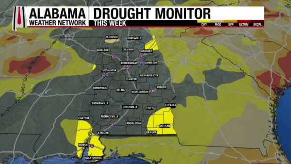
Alabama still seems incapable of erasing the last of spring’s drought. The Moderate Drought in the northwest remains unchanged compared to last week, and although portions of Abnormally Dry Conditions in the northern half of the state have improved, portions of southwest and southeast Alabama now struggle with the same conditions. While 91.69% of the state was drought-free last week, 86.30% is drought-free this week.
TROPICAL STORM GENEVIEVE
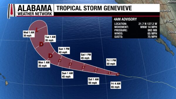
Genevieve has now weakened to tropical storm strength, with sustained winds of 65 mph and a central pressure of 993 mb. It will move west-northwest throughout today and this weekend as a tropical storm until it weakens to a tropical depression by Monday morning.
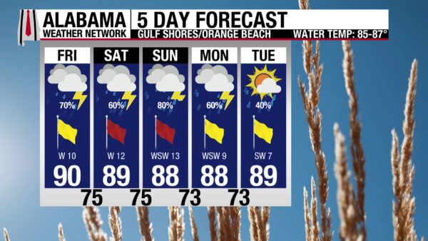
RAIN AND STORMS AT THE BEACH THIS WEEKEND
Today through Monday will have a medium to high chance of rain and thunderstorms. Today features a 70% chance of thunderstorms, expected in the afternoon. Despite the rain, skies will still be partly cloudy, and the UV Index will still be Extreme. Additionally, the high will be around 90 degrees, and the winds will blow from the west at 10 mph. The rip current risk is Moderate, and the surf height is around 2 feet. Tomorrow features a 60% chance of thunderstorms with a High rip current risk, and Sunday has an 80% chance of storms with the same rip current risk.
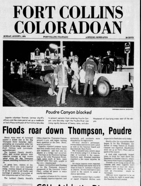
TODAY IN WEATHER HISTORY
July 31, 1976 – Big Thompson Flood
On July 31, 1976, Big Thompson Canyon was crowded for a summer holiday weekend. Colorado was celebrating its centennial, and thousands of campers, hikers, residents and travelers had gathered in one of the state’s most scenic canyons. U.S. 34 followed the Big Thompson River through the narrow corridor, putting cabins, campgrounds, cars and people close to the water.
The weather setup became dangerous that evening. Easterly surface winds pushed warm, humid air up the Front Range of the Rockies. As that unstable air rose, thunderstorms developed near Estes Park and the Big Thompson River basin. Winds aloft were weak, so the storms did not move away. They stayed nearly stationary over the same steep terrain for hours.
The rainfall was extreme. Up to 12 inches fell in only a few hours, including 7.5 inches in 1 hour near Glen Comfort. The canyon walls and thin mountain soils could not absorb that much water. Runoff poured into tributaries and the Big Thompson River, driving streamflow from about 127 ft³/sec before the flood to 31,200 ft³/sec at the canyon mouth.
The flood became a violent wall of water moving through the canyon. It swept away homes, vehicles, bridges, power lines, and much of U.S. 34. People were trapped in cabins, campgrounds, and cars, while others climbed canyon walls or clung to trees to survive. By the end, 144 people had died, more than 250 were injured, and 5 bodies were never recovered.
The damage topped $35 million, and the highway took months to fully restore. But the flood’s legacy lasted far longer than the repairs. Warning signs in Front Range canyons now tell people to climb to safety during flash floods. The Big Thompson Flood became a disaster through an unfortunate combination of steep canyon terrain, a stationary thunderstorm and holiday crowds.
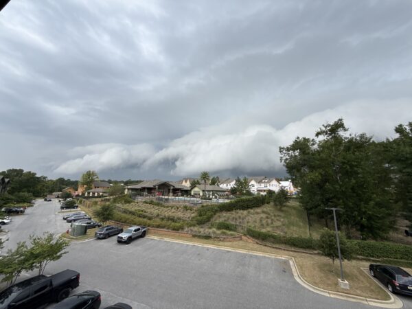
IMAGE OF THE DAY
FireFighterSewell Media took this photo of an ominous shelf cloud over Fairhope yesterday afternoon.



