


Daily Weather Briefing
Saturday, August 1, 2026
ALABAMA THIS MORNING
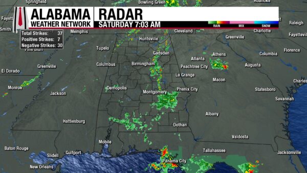
This morning is gloomy as clouds stretch across the state, and northwest, southwest, and much of eastern Alabama wake to morning showers and thunderstorms. Temperatures sit in the mid 70s statewide, with southwest Alabama seeing the upper 70s.
ALABAMA 7 DAY FORECAST
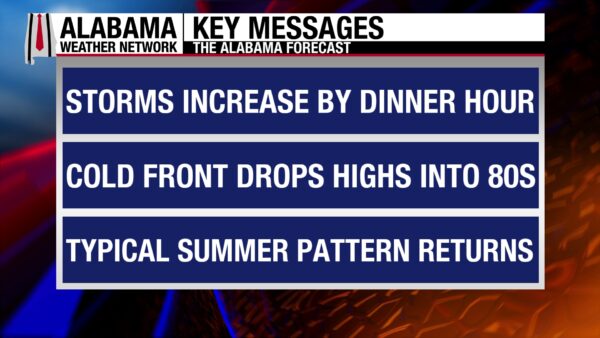
Scattered showers and thunderstorms are possible through the day today before an organized line pushes through Alabama along a cold front this evening, bringing a low threat of severe weather. Tomorrow through Tuesday will feature low to medium rain chances with no severe weather threat and highs in the upper 80s to lower 90s. The second half of the week will be drier as an upper-level ridge begins to move over the state, keeping rain chances limited and high temperatures hotter.
A FEW STORMS TODAY, GREATER CHANCE FOR STORMS TONIGHT – Aug 1
Skies will be mostly cloudy today, and showers will be scattered statewide throughout the day. These conditions are due to the increasing moisture in the state ahead of the cold front that will approach the state today. Highs will be limited to the low 90s across the state, with a few locations in the southeast staying in the upper 80s.
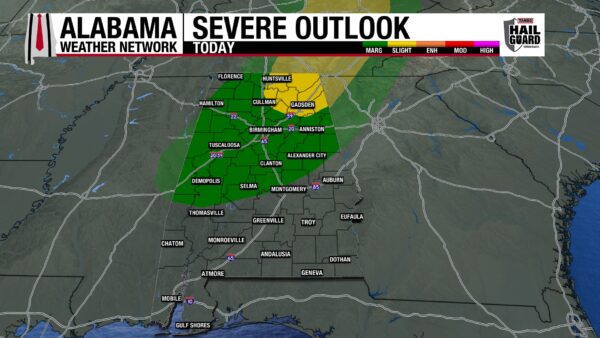
Tonight is the main story. The cold front will push through the state this evening into the night, bringing an organized line of showers and thunderstorms with it. The Storm Prediction Center has placed a Slight Risk (2/5) outlook for severe weather over northeast Alabama, and a Marginal Risk (1/5) outlook for the rest of north Alabama and as far south as just north of Montgomery. The northwest sliver of Alabama, however, has been excluded. Any severe storms that develop in the outlooked region will be capable of producing damaging winds, frequent lightning, and heavy downpours that could lead to flash flooding. South-central and south Alabama will not have to worry about severe threats, but gusty winds and heavy rains that lead to flash flooding can be expected. Timing for north and central Alabama is around 3-11 p.m., with models leaning more towards past 5 p.m. for storms and the front to pass through. South Alabama will see storms roll in near 11 p.m. and continue through the early morning hours of Sunday. Storms should be to the east of south Alabama by 7 a.m. tomorrow morning.
SCATTERED SHOWERS SUNDAY THROUGH TUESDAY – Aug 2-4
After the front pushes through the state, showers and thunderstorms will return to a scattered afternoon pattern, and skies will stay partly to mostly cloudy. This pattern will take place Sunday through Tuesday this week. Sunday’s highs will range from the mid 80s north, upper 80s centrally, to the upper 80s and lower 90s south; the cooler temperatures due to the slightly cooler air behind the front and the lingering clouds. The same temperature range is expected Monday as well, then the upper 80s are expected north while the rest of the state sits in the lower 90s on Tuesday.
HOTTER AND DRIER TO END THE WEEK – Aug 5-7
Wednesday through Friday will see the pattern shift from wetter and cooler to drier and hotter as the upper-level trough associated with the low-pressure system responsible for today’s weather is booted out of the Southeast by an upper-level ridge pushing in from the west. Rain chances will be isolated to scattered in the afternoon each day. Highs each day will sit in the low 90s.
RAINFALL OUTLOOK
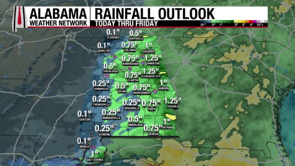
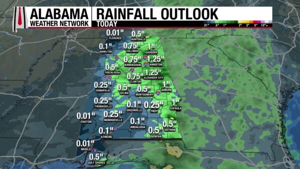
Alabama will receive anywhere from only a tenth of an inch of rain up to 2 inches over the next seven days, but the catch is the majority of this rain will fall today. Today, the western third of Alabama will receive up to a quarter of an inch of rain. The eastern two-thirds of the state is expected to receive half an inch to an inch and a quarter, with isolated locations expecting 2 inches. When comparing the expected rainfall over the next week and today, it’s clear that today and this evening’s storms are the rainmakers for the week.
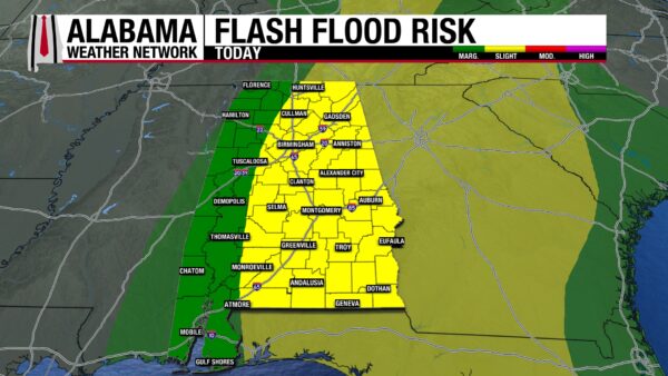
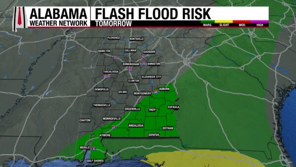
Because most of the rain this week will fall today, the Weather Prediction Center has placed the eastern two-thirds of Alabama under a Slight Risk (2/4) for Flash Flooding and the western third under a Marginal Risk (1/4). The atmosphere is very moist, and storms will have no issues producing downpours. If you encounter a flooded roadway, remember: Turn Around, Don’t Drown. There is a Marginal Risk for Flash Flooding across south Alabama as storms push through the region tomorrow morning.
SLIGHT WORSENING OF DROUGHT CONDITIONS
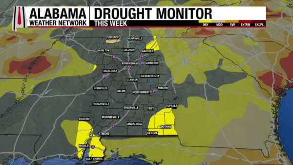
Alabama still seems incapable of erasing the last of spring’s drought. The Moderate Drought in the northwest remains unchanged compared to last week, and although portions of Abnormally Dry Conditions in the northern half of the state have improved, portions of southwest and southeast Alabama now struggle with the same conditions. While 91.69% of the state was drought-free last week, 86.30% is drought-free this week.
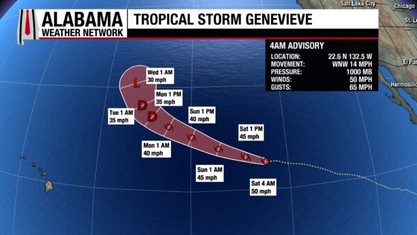
TROPICAL STORM GENEVIEVE
Tropical Storm Genevieve sits in the Pacific with sustained winds of 50 mph and a central pressure of 1000 mb. Genevieve will weaken slowly and finally become a depression by Monday. It will not impact land. Otherwise, both the Eastern Pacific and the Atlantic are quiet.
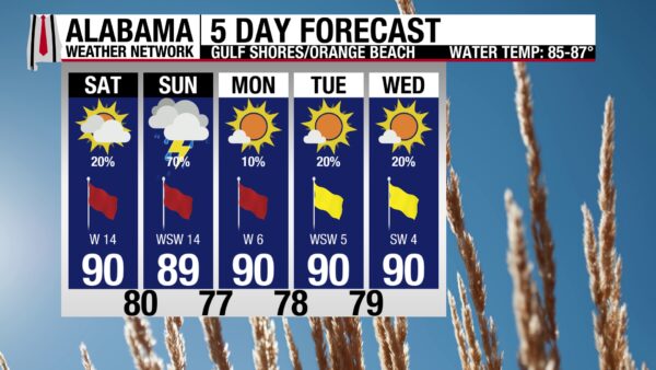
DECENT WEATHER TODAY, STORMS TOMORROW MORNING ON THE COAST
Today, there is a 20% chance of afternoon and evening showers and thunderstorms on the coast. Beachgoers should still be able to enjoy the beach today with a high around 90 degrees, mostly sunny skies, and a Very High UV Index. Winds will be breezy at 15 mph from the west, and the surf will be rough and dangerous with a High rip current risk and surf heights of 3-4 feet. A 70% chance of showers and thunderstorms exists for the beach tomorrow, pushing through mostly in the morning. The afternoon should clear and be pleasant, but the rip current risk will still be high. Rain chances will decrease next week, and we will return to normal summer beach weather.
TODAY IN WEATHER HISTORY
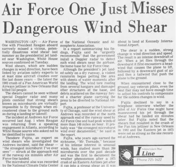
August 1, 1983 – Minutes From Danger
On August 1, 1983, President Ronald Reagan landed aboard Air Force One at Andrews Air Force Base in Maryland just minutes before one of the most violent microbursts ever measured struck the airfield. What could have been a routine summer arrival instead became a chilling reminder of how quickly thunderstorms can become dangerous around aircraft.
A powerful thunderstorm moved over Andrews shortly after Air Force One landed. The storm then produced a microburst, which is a concentrated downburst of strong winds that crashes out of a thunderstorm, hits the ground, and spreads outward. Near an airport, that sudden outward rush of wind can create dangerous low-level wind shear for aircraft taking off or landing.
At Andrews, the wind was extreme. The base anemometer recorded a gust of 149.5 mph, considered the strongest microburst ever measured at an airport. The National Weather Service has noted that the sensor was not calibrated for winds that extreme, but the reading still became one of the most remarkable thunderstorm wind measurements on record.
The timing made the event especially sobering. Had Air Force One arrived only a few minutes later, it could have encountered severe wind shear close to the ground, where aircraft have very little time or altitude to recover. Instead, the president was already safely on the ground. After the storm disrupted operations, Reagan traveled by motorcade to the White House because helicopter operations were grounded.
Microbursts later became one of the major aviation-weather concerns of the 1980s. Two years after the Andrews event, Delta Air Lines Flight 191 crashed while approaching Dallas/Fort Worth during a thunderstorm microburst, helping push major improvements in wind-shear detection, pilot training and airport warning systems. The close call reminds aviators and passengers how dangerous thunderstorms can be to aircraft in flight.

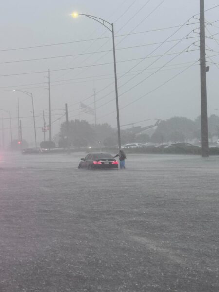
IMAGE OF THE DAY
These images are from James Spann on X of the flash flooding in Tuscaloosa yesterday evening.



