


A Beautiful Saturday — But Change Is Coming Fast
What a day it’s been across Alabama. Mid 70s to lower 80s, gorgeous blue skies, flowers popping up everywhere. SkyWatcher Sandra Kirkwood sent in a beautiful photograph of the mural in Cleveland in Blount County, and Vanessa Sanchez shared some stunning azaleas. Spring is absolutely showing off today. Gulf Shores is packed with spring breakers having a ball. But enjoy it while it lasts, because what’s coming tomorrow night is a very different story.
Severe Storms Sunday Night — 75 MPH Winds Possible
The Storm Prediction Center has issued an enhanced risk — level 3 out of 5 — for Northwest Alabama, with a slight risk covering much of the rest of the state. The primary threat is damaging winds, and we’re not talking about the usual 60 mph. Winds could reach 75 miles per hour with this system. That can be very damaging to the power grid, to trees, and to structures. We don’t want to see any tragedies tomorrow night, so please be ready.
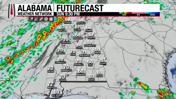
Here’s the timeline: storms should reach northwestern Alabama by around 8:00 Sunday evening. The main line will sweep southeast through the state overnight, reaching the Montgomery and Alex City areas around 2:30 AM and clearing the southeast corner by early Monday morning. Embedded tornadoes are possible within the line, and any isolated cells that develop out ahead of it will have enough instability and shear to produce tornadoes as well. Gale watches are already posted for the Mississippi Sound and offshore waters, and additional warnings will be issued tomorrow.
Snow Flurries and a Hard Freeze
Behind the storms, things get cold in a hurry. On the backside of this system, rain could change to a mix of rain and snow in the northwest corner of the state as temperatures fall through the 40s into the 30s. Yes, I said snow. The chance of any accumulation is very small — the European model puts it at less than three percent — but snow flurries are possible late Sunday night into Monday.
The bigger concern is the freeze. A hard freeze arrives Monday night into early Tuesday morning, and another freeze is likely Tuesday night into Wednesday. If you’ve been planting, you’ll want to protect everything. Even outside the thunderstorms, wind gusts will average 20 to 25 mph on Sunday, occasionally hitting 30, and those gusts will continue through Monday, making for some really chilly wind chills.
Looking Ahead
Rainfall totals from this system look modest — a quarter to maybe three-quarters of an inch. That’s not going to break the drought, but we’ll take what we can get. Temperatures will gradually moderate by midweek, and strong high pressure builds back in by late in the week. The severe weather, the snow potential, and the freeze will all be a distant memory by then. But first, we have to get through tomorrow night. Be weather aware, have multiple ways to receive warnings, and have a plan.



