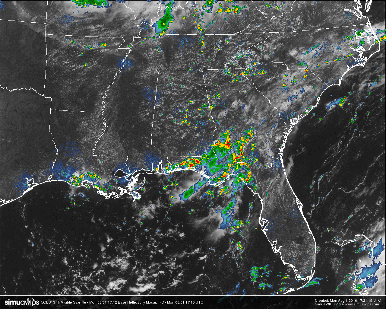

Skies across Central Alabama at this hour are partly to mostly clear with the typical cumulus clouds overhead that form during a summertime day. On the radar, we have a few scattered showers that have formed mainly south of I-20 and east of I-65 at this point, we a few isolated showers dotting the radar up in northwestern sections of the area. Most, if not all, of these cells are moving to the southeast.
Across the southeastern United States, a mass of showers and thunderstorms are located on the extreme southeastern corner of the state, just about the whole panhandle of Florida, and the southwestern parts of Georgia. There are no severe warnings issued for anyone in the southeast at this moment, but we do note that the SPC has areas of northeastern Arkansas and western Tennessee, along with eastern North and South Carolina, defined in a “Marginal Risk” for severe storms throughout the remainder of the day. The main risks for both of these areas will be from strong winds from wet microbursts and dangerous cloud-to-ground lightning.
TEMPERATURES AT THIS HOUR: With the skies being mostly clear out there, the temperature is climbing its way on up to the daytime maximum without any impedance. Here is a list of temperature observations from across the area:
Birmingham 88
Tuscaloosa 89
Gadsden 89
Anniston 88
Cullman 87
Hamilton 91
Clanton 90
Alexander City 88
Montgomery 92
WHAT TO EXPECT FOR TODAY: With a surface boundary that has stalled out across southern portions of the state, and with an outflow boundary moving in from a MCS that was in Missouri last night, we will keep our chances of showers and thunderstorms around 50%. Otherwise, skies will be partly cloudy with highs in the low 90s for the most of Central Alabama, with mid 90s in the southern parts of the area. It looks like the higher chances for rain will be for areas south of I-20, but chances will be decent area wide. Showers and storms could last well into the evening, and overnight lows will be in the 70s.
CODE YELLOW AIR QUALITY: The Air Quality Index for the Birmingham Metropolitan Area will be in the “Code Green” for ozone. No actions needed for today.
TODAY’S CLIMATOLOGY FOR BIRMINGHAM: The normal high for August 1st is 91, while the normal low is 72. The record high for today was set back in 2010 at 101. The record low was set back in 1925 at 59.
TUEDAY’S OUTLOOK: Looks like that the shower and thunderstorm chances will remain a little higher than a typical summertime day in Central Alabama, as we still have a weakness in the upper levels. Skies will be partly to mostly sunny with a risk of scattered showers and thunderstorms mainly during the afternoon and evening hours, but don’t be surprised if one or two form during the late morning hours. Highs will be in the low to mid 90s.
HEADED TO THE BEACH: Standard summer weather will persist for the beaches of the Northern Gulf Coast. More sun than clouds, and there will be a few passing scattered storms from time to time. Highs will be in 87-90 on the beaches, while just inland you can expect low to mid 90s. There may be some rip current issues, so please pay attention to the flags posted along the beaches. See a very detailed Gulf Coast forecast here.
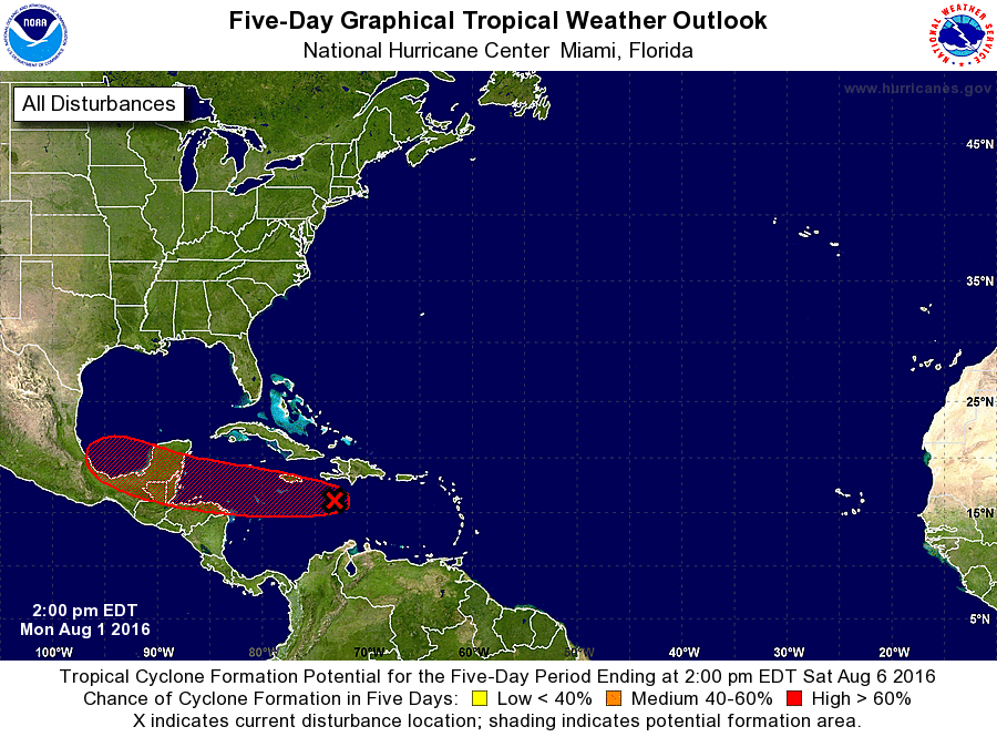
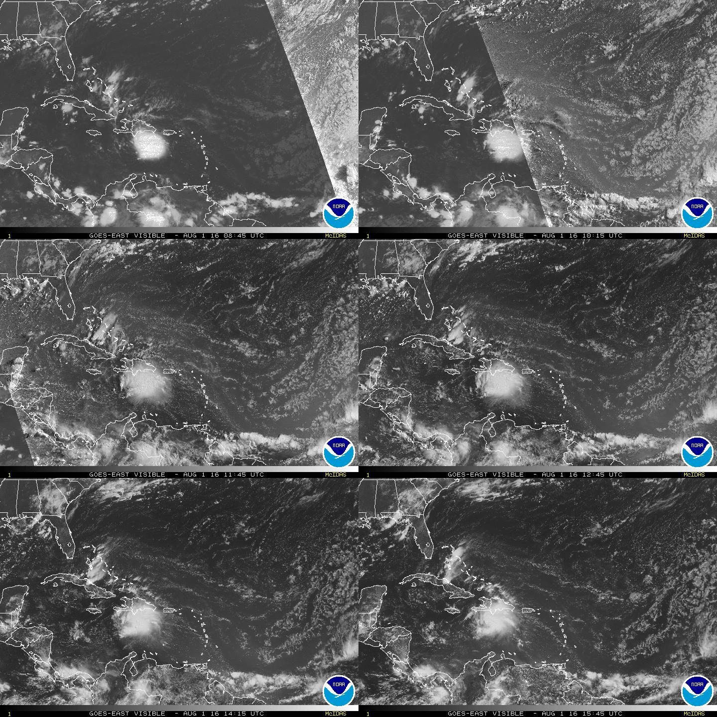
THE TROPICS: We have a strong tropical wave moving across the Caribbean basin, and is expected to have some gradual development through the next day, then a decent chance of it forming into a tropical cyclone when it reaches the western Caribbean Sea in a couple of days. This wave/cyclone is expected to move into the Yucatan Peninsula of Mexico by the weekend. We may be looking at our next named storm, which would be Earl. We are getting closer to the most active part of the hurricane season, and as expected its starting to get active.
THE BLOG IS ON TWITTER: Be sure to follow the Alabama Wx Weather Blog on Twitter. Just click here to start following our feed.
WEATHERBRAINS: This week, the panel will entertain Charlie Woodrum, who is the Warnings Coordination Meteorologist for the NWA Central Pacific Region. This is the show all about weather featuring many familiar voices, including our meteorologists at ABC 33/40. You can listen anytime on the web, or on iTunes. You can find it here.
ADVERTISE WITH US: Deliver your message to a highly engaged audience by advertising on the AlabamaWX.com website. The site enjoyed 10.2 MILLION pageviews in the past 12 months. Don’t miss out! We can customize a creative, flexible and affordable package that will suit your organization’s needs. Contact Bill Murray at (205) 687-0782.