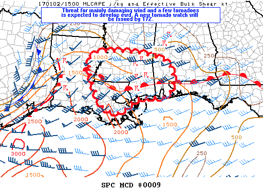
Here is the latest Mesoscale Discussion from the SPC…
Mesoscale Discussion 0009
NWS Storm Prediction Center Norman OK
1017 AM CST Mon Jan 02 2017
Areas affected…southeast Louisiana through southern Mississippi
Concerning…Severe potential…Tornado Watch likely
Valid 021617Z – 021815Z
Probability of Watch Issuance…95 percent
SUMMARY…The threat for damaging wind and a few tornadoes is expected to increase from southeast Louisiana through southern Mississippi into southwest Alabama from late morning into the afternoon. A tornado watch will likely be issued for this region by 17Z (11:00 AM).
DISCUSSION…This morning a coastal warm front extends from the FL Panhandle through the MS boot heel into southeast and west central Louisiana where it intersects a pre-frontal squall line. Widespread clouds have been a limiting factor so far for a more robust severe threat. However, the moist boundary layer south of the warm front is destabilizing, primarily due to theta-e advection, but some cloud breaks will be possible this afternoon supporting MLCAPE from 1000-1500 j/kg. The squall line will likely continue east next several hours as it intercepts the moistening boundary layer along and south of the warm front. Additional more discrete storms will likely continue developing within pre-frontal confluence bands within the destabilizing warm sector. Some strengthening of broad southwesterly low-level jet will occur into the afternoon in association with forcing for ascent accompanying the progressive southern-stream shortwave trough. This will maintain sufficiently large 0-2 km hodographs for a threat of low-level mesocyclones and a few tornadoes, especially as discrete storms become surface-based ahead of the line. Brief QLCS tornadoes in addition to damaging wind will remain the primary threats within the squall line.