


Our line of strong storms continues moving southeastward across Alabama this afternoon. I is now crossing through the I-59 Corridor, keeping to the schedule we predicted this morning.
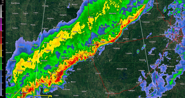
At 330 p.m., the line of storms extended from east of Gadsden to Pell City to Inverness to Alabaster to west of Brent to northwest of Demopolis. It is moving southeast at 25 mph while individual storms are moving east northeast at 35 mph.
The storms are strongest from the Birmingham Metro back to the southwest.
The severe thunderstorm warning has been canceled for Jefferson and Shelby Counties. The Jefferson County storms have weakened.
All along the line, you can expect very heavy rain, deadly lightning and gusty winds. We can’t rule out additional storms becoming severe, especially southwest and south of Birmingham. The severe threat will be over when the line of storms passes your location.
TIMING…The line will reach the following locations at the following times:
…Anniston 3:45 p.m.
…Talladega 3:50 p.m.
…Columbiana/Calera 4:00 p.m.
…Childersburg 4:15 p.m.
…Sylacauga 4:30 p.m.
…Jemison 4:35 p.m.
…Clanton 4:45 p.m.
RAINFALL…Most areas should pick up three quarters to one inch of rain from the rain and storms.



