


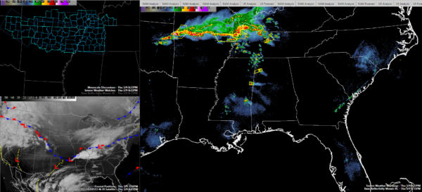
The opening round of tonight’s event continues to play out over Northwest Alabama and Northeast Mississippi this evening and the main event will come later tonight.
Storms that formed over eastern Mississippi this afternoon have been in an environment of very strong low level lapse rates. This had led to some vigorous updrafts that have produced lots of hail. They have also been enhanced by strong mid-level winds.
Hail to golf ball size has been reported from a few locations over Northeast Mississippi and Northwest Alabama including a recent report just southwest of Hamilton. 1.5 inch hail was also reported at Weston, west of Hamilton.
A severe storm is approaching Hamilton now. It will move to near Haleyville and Bear Creek. Large hail the main threat. Could be some damaging winds also.
Another will be approaching Pickens County by 845 p.m. More large hail and damaging winds possible.
These storms should weaken as they move further into Alabama and outrun the best wind shear.
But the real trouble for tonight is to the northwest. A mesoscale convective system (MCS) has developed over southern Missouri. It is producing numerous severe thunderstorm and tornado warnings across extreme southern Missouri and northern Arkansas. The activity is also pushing into Southwest Kentucky and Northwest Tennessee.
Severe thunderstorm watched over areas from Northeast Oklahoma across northern Arkansas and southern Missouri into Southern Illinois, Southwest Kentucky and western Tennessee.
There is a weak surface low near Poplar Bluff. That low will track east southeast overnight. They MCS will track southeast, holding together until it gets into Central Alabama.
The storms are on track to arrive in Northwest Alabama around midnight. They will push southeast to Cullman and Jasper between 1-1:30 a.m. and Gadsden around 2 a.m. They will reach Birmingham/Tuscaloosa/Anniston between 2-2:30 a.m.
They should be weakening by then, but damaging winds are possible as far south as I-20.
Make sure you have a way to receive warnings overnight. If a severe thunderstorm warning is issued for you area, please take it seriously. All it takes is one tree falling on your house to become a tragedy. You don’t want to be in a mobile home in a severe thunderstorms warning. Make arrangements to leave them well before the storms arrive.



