


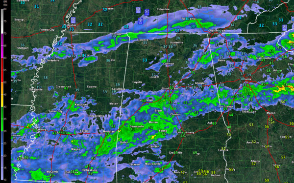
A band of mixed precipitation is dropping southeastward across northern Mississippi tonight.
It dropped just under an inch of snow in the Memphis area.
It extends from Clarksdale to Oxford to Corinth. It is just now entering the Northwest Corner of Alabama.
The precipitation will be a mix of light rain and light snow across Marion, Winston and Cullman Counties, generally along and north of US-278. They could be a few snowflakes mixed in across parts of Lamar, Fayette and Walker Counties as well.
Road surface are warm and it does not appear precipitation rates will be sufficient to cause accumulations on streets and highways. There could be light accumulations on grassy areas and roofs across parts of Lauderdale, Limestone and Madison counties. The higher elevations of Jackson and DeKalb Counties may see up to an inch of snow. A winter weather advisory is in effect for Jackson and DeKalb Counties.
Temperatures have fallen to 33F at Haleyville at Florence. Further south it is 37F at Jasper. Birmingham and Birmingham are down to 40F.
Across North Alabama, rain showers are over Winston and Cullman counties. Another batch of showers is over DeKalb and Etowah Counties. They are moving into Cherokee County. The main band of rain is now dropping south of I-20. It will continue moving southeastward through the night.



