Alabamians are waking up to a cloud filled sky this morning, but temperatures are mild with most places in the lower 70s. Radar was already active this morning with numerous showers across the state. The Southeast US regional radar composite resembled a patient with the measles. The short story on the forecast is that it will remain wet, humid, and showery through midweek when a cleansing surface front and an upper trough will rid us of the humidity.
For today, the weak upper trough to our west has done pretty much what was expected as it moved ever so slowly eastward. The trough reaches the Southeast Texas coast on Monday and will help to generate a weak surface low over that region. The surface low will move slowly along the Gulf Coast as does the upper low. Wednesday we see a great deal of improvement as the weak upper low along the Gulf Coast phases with a strong trough rotating around a closed low over the eastern Great Lakes area.
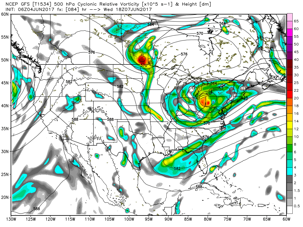
This puts Central Alabama squarely in a northwesterly flow pattern which ushers in some much drier air. You should see dew points drop from the upper 60s to the lower 50s on Wednesday. Our highs won’t drop much thanks to all the showers and cloud cover, but I think you’ll really notice a difference for Wednesday and Thursday with that lower humidity.
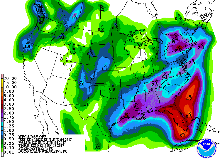
Rainfall through Wednesday will come in the form of showers, so not everyone gets the same amount of rain. I saw no showers at my house yesterday, but there were showers close by so some got a good shower. Rainfall amounts will be in the range of 1 to 2 inches through the end of the rain on Wednesday.
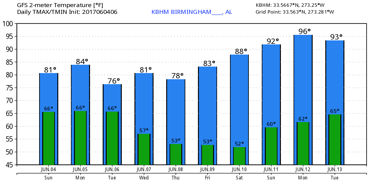
The northwesterly flow stays with us for Thursday and Friday, but by Saturday the upper ridge to our west begins to become the principal player in our weather pattern, so look for humidity levels to come up once again as highs begin to edge very close to 90 degrees. For the weekend, the surface high will move off the Southeast US Coast, so humidity levels come up, but with the upper ridge in place over us I think we’ll stay dry.
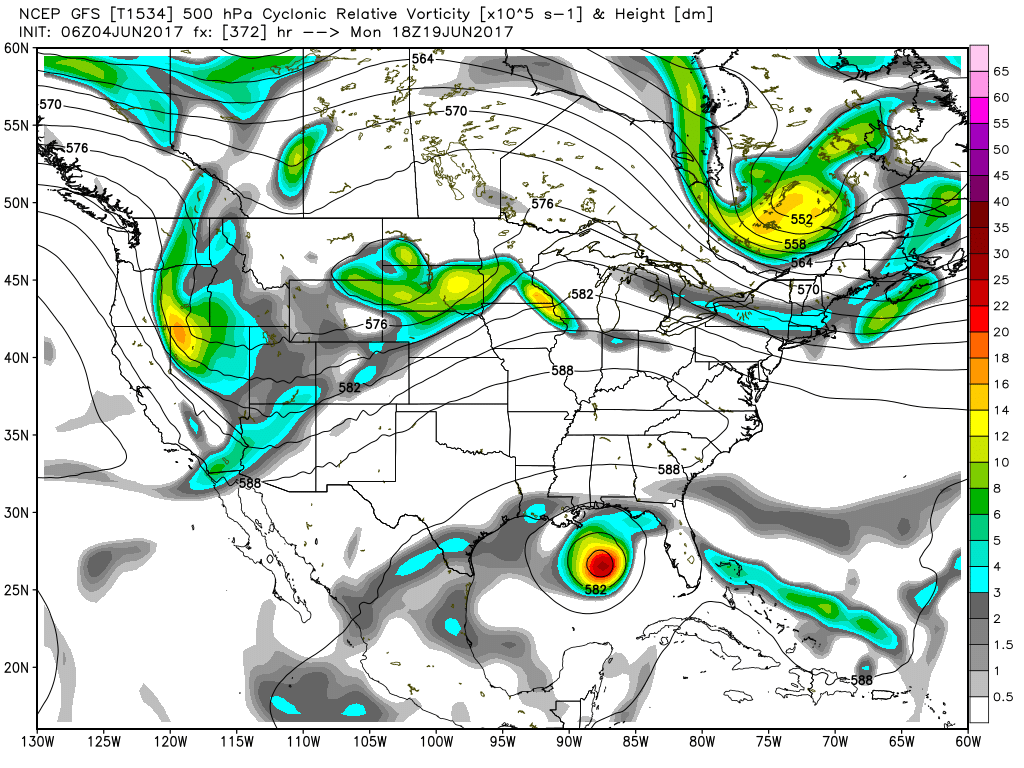
Looking out into voodoo country, the GFS is very bullish on a strong ridge over the eastern part of the country. But the GFS also has some tropical mischief that will get people talking. First, the GFS signals a tropical system near Bermuda, and then by June 19th, the GFS brings a tropical system into the Gulf of Mexico just south of Mobile. Remember, this is voodoo country, and I will not be surprised to see that feature gone in the next run.
If you are headed to the beach, you’ll see showers almost everyday through midweek, with improving weather for the end of the week. Highs will be in the lower 80s. For a detailed look at the weather from Fort Morgan to Panama City Beach, click here to see the AlabamaWx Beach Forecast Center page. The Beach Forecast is partially underwritten by the support of Brett/Robinson Vacation Rentals in Gulf Shores and Orange Beach. Click here to see Brett/Robinson’s Own Your Summer specials now!
I’m very excited to be narrating a special performance of the Helena United Methodist Church bell choir at Cahaba Heights United Methodist Church this morning during the 11 am worship service. Always great to hear the bells, and such an honor to narrate for them. James Spann is expected back with the next edition of the Weather Xtreme Video on Monday morning. I bet that tropical mischief has disappeared, so I get all the fun of talking about it. Have a great day, stay dry! Godspeed.
-Brian-