


The radar check at 5:50 PM shows the outer rain band of Subtropical Storm Alberto continuing to make its way northwestward making it to Fruithurst (Cleburne Co.) to Lincoln (Talladega Co.) to Montevallo (Shelby Co.) to Marion (Perry Co.). This feeder band is moving about 10 MPH generally to the northwest, while the cells within the band are moving west-southwest at about 20 MPH.
The heaviest rainfall at the moment is occurring on the leading edge of the northern part of the line over parts of Calhoun, Cleburne, and Talladega counties, but the reflectivity has decreased in intensity somewhat over the past hour.
The good news is that there have been no reports of any circulations developing in the feeder band so far as the part of the band affecting the area is currently northwest of the center of circulation. Any isolated tornadoes will occur on the east and northeast side of the center. We still have several hours before any part of Central Alabama will fall into that threat.
As this band continues to move toward the Birmingham Metropolitan Area, we can expect winds gusting to 15-25 MPH, some heavy rainfall that could lead to some ponding in poor drainage areas, and the possibility of a few claps of thunder. If you hear thunder, you are close enough to the parent thunderstorm to be struck by lightning. When thunder roars, go indoors.
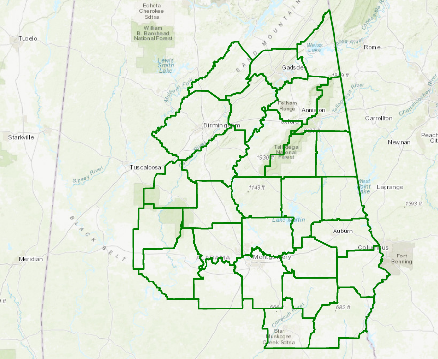
A Flash Flood Watch continues in effect until 7:00 PM Tuesday evening for Autauga, Barbour, Bibb, Blount, Bullock, Calhoun, Chambers, Cherokee, Chilton, Clay, Cleburne, Coosa, Dallas, Elmore, Etowah, Jefferson, Lee, Lowndes, Macon, Montgomery, Perry, Pike, Randolph, Russell, Shelby, St. Clair, Talladega, and Tallapoosa counties. We still have the potential for 4-6 inches of rain to fall over the counties in the watch, with the rest of the area with the possibility of 1-3 inches of rain.

A Flash Flood Watch also continues in effect until 7:00 AM Wednesday morning for all of North Alabama (Colbert, Cullman, DeKalb, Franklin, Jackson, Lauderdale, Lawrence, Limestone, Madison, Marshall, and Morgan counties).
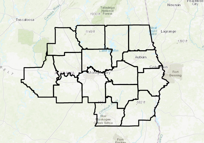
A Wind Advisory continues in effect until 7:00 AM Tuesday morning for Autauga, Barbour, Bullock, Chambers, Chilton, Coosa, Dallas, Elmore, Lee, Lowndes, Macon, Montgomery, Pike, Russell, and Tallapoosa counties. Winds of 20-30 MPH with gusts up to 40 MPH will be possible starting in the southeastern parts of the area and slide northward throughout the evening.
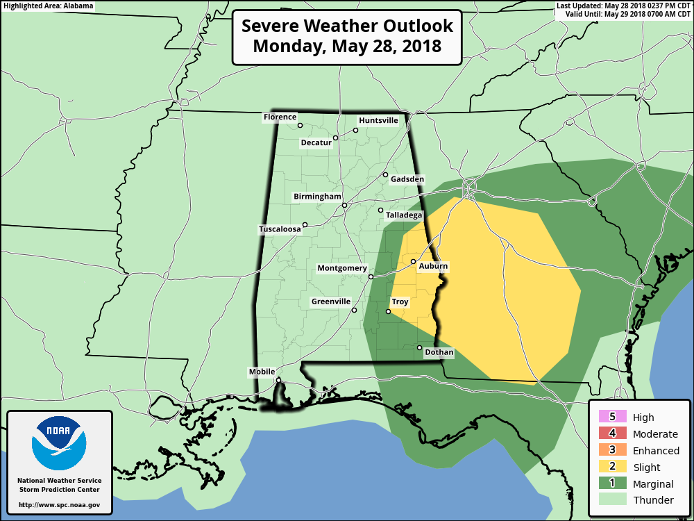
There is a Slight Risk for severe storms for the remainder of today through 7:00 AM Tuesday defined in the southeastern parts of Central Alabama for locations east of a line from Troy (Pike Co.) to Daviston (Tallapoosa Co.) to Roanoke (Randolph Co.). A Marginal Risk for severe storms has been defined stretching westward from the slight risk area to a line stretching from roughly Montgomery to Goodwater (Coosa Co.) to Ranburne (Cleburne Co.). The main threat will be from gusty winds associated with Alberto, along with the possibility for a few spin-up tornadoes.
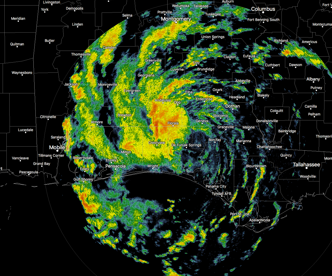
Down on the coast, conditions are starting to improve a little. NWS Mobile has allowed the Wind Advisory to expire for their county warning area (Baldwin, Butler, Conecuh, Crenshaw, Escambia, and Mobile counties in Alabama, and Escambia County in Florida). Rainfall on the east side of the circulation center has relaxed some, giving several location a break from heavy tropical downpours. Winds at Panama City were at 21 MPH out of the south, with gusts up to 32 MPH… a big difference from the 58 MPH gust we saw earlier from Tyndall AFB. The center of circulation is currently over De Funiak Springs and is continuing to move north at 9 MPH, with maximum sustained winds at 45 MPH.



