


Latest update from the Storm Prediction Center has a decent chance of a Severe Thunderstorm Watch being issued over the northern half of the state sometime this afternoon. Here is the latest mesoscale discussion…
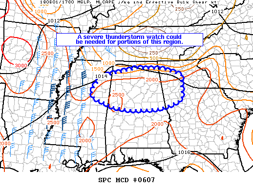
Mesoscale Discussion 0607
NWS Storm Prediction Center Norman OK
1225 PM CDT Fri Jun 01 2018
Areas affected…Parts of northern GA through northern/central AL to northeast MS
Concerning…Severe potential…Watch possible
Valid 011725Z – 012000Z
Probability of Watch Issuance…60 percent
SUMMARY… Thunderstorms are expected to increase in coverage this afternoon across northern and central Alabama, parts of northern Georgia, and possibly across parts of northeast Mississippi with some of the storms becoming severe producing strong wind gusts and large hail. Severe thunderstorm watch could be needed for portions of this region.
DISCUSSION… Trends in mosaic radar imagery and lightning data indicated some increase in coverage with a band of storms advancing to the south-southeast across northern AL, while additional storms were developing along a surface boundary that extended from north-central GA into central AL. Despite a modest increase in effective bulk shear, surface heating within a moisture-rich environment and steep low- to mid-level lapse rates will contribute to further destabilization through the afternoon. These latter factors suggest locally strong wind gusts and large hail will be possible with stronger storms.



