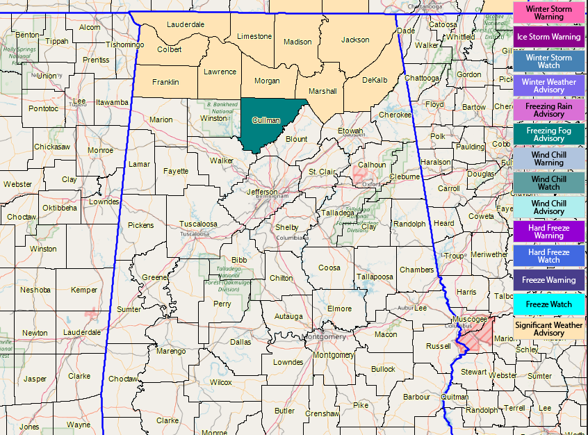
AT 6:30 AM: We have a significant weather advisory in effect for all counties in the North Alabama area until 9:00 AM for dense fog, some of which could be freezing fog. If you’re out on the roadways in that part of the state, just be really careful as some slick spots could develop on bridges that cross over any bodies of water. A Freezing Fog Advisory was just issued for Cullman County until 9:00 AM.
SATURDAY: We’ll have a high parked over the Gulf Coast throughout the day today which will bring us plenty of sunshine early. We’ll have a cold front approaching from the west which means clouds will start to roll in during the afternoon and evening hours, but we’ll stay dry. Today’s highs will top out in the 50s across the area. Skies will be mostly cloudy throughout the late night and overnight hours and lows will be in the mid-30s to the lower 40s.
SUNDAY: A cold front will work through the area on Sunday, bringing with it a chance of a few passing showers across Central Alabama. Rain chances range from 20-40% north of the I-85 corridor and less than 20% south of that. Skies will be partly to mostly cloudy when it is not raining and afternoon highs will top out in the mid-50s to the mid-60s. At this point, the window for rain will be from 6:00 AM to 6:00 PM.
MONDAY: We’ll have a zonal flow across the US on Monday meaning that we’ll have a calm weather pattern across Central Alabama. We’ll have a good bit of sunshine with just a few clouds passing by, but the day will be a little cool. Afternoon highs will be in the 50s across the area.
TUESDAY: This latest run of the GFS is actually keeping us dry throughout Christmas Day, while the last few runs had some shower activity moving through the area. I’m going to keep a very, very small chance of a few passing light showers in the forecast throughout the day, but I would say the odds for any one spot getting rain will be less than a 1-in-5 shot. We’ll have a mix of sun and clouds and highs will be in the mid-50s to the lower 60s.
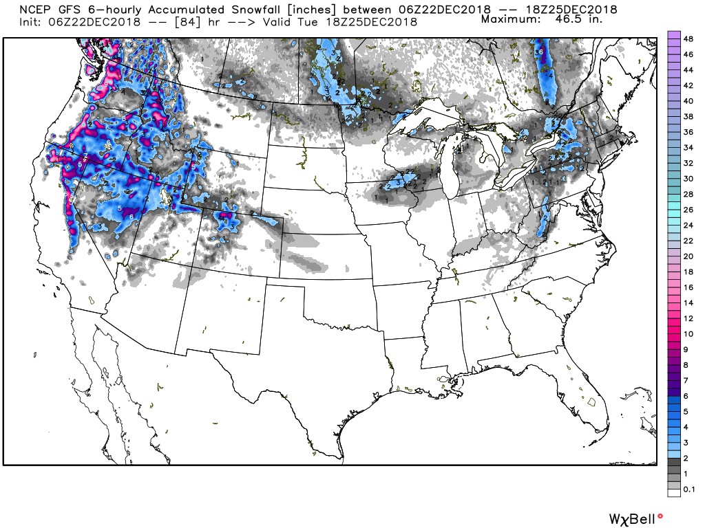
Just for fun, if you want to have a White Christmas for this year, the best places to be are out in the mountains out west and up in the Great Lakes region. We’ll have to wait 367 more days to see if we have a chance for one in Central Alabama in 2019.
WEDNESDAY: A trough will really begin to deepen over the southwestern US while we’ll have ridging just off to our west. We’ll have mostly cloudy skies to start off the day with the cloud cover increasing through the day. Some showers may start moving in during the late afternoon but rain will become likely across the area before midnight. Highs will top out in the upper 50s to the mid-60s.
THURSDAY: A vigorous low will start off Thursday morning located over the extreme northern parts of Texas and will be moving to the northeast rather rapidly. By noon, the low will be centered over the north-central parts of Kansas. Out ahead of the associated cold front, we’ll have a good bit of warm, moist air being pulled into Central Alabama from the Gulf. That means we’ll have showers and thunderstorms throughout the day and nighttime hours. While there will be a decent amount of instability, we do not believe that severe weather will occur at this time as that instability will be elevated. Afternoon highs will be in the lower to mid-60s. Rainfall amounts look to be in the 1-2 inch range throughout the day with localized heavier amounts possible.
FRIDAY: By midday on Friday, the low will have sped well off to the northeast and will be in the Great Lakes region. We’ll continue to have some shower activity through the area during the day and into the evening hours. Highs will be in the 60s throughout Central Alabama. Our southern locations could actually get very close to 70 degrees.
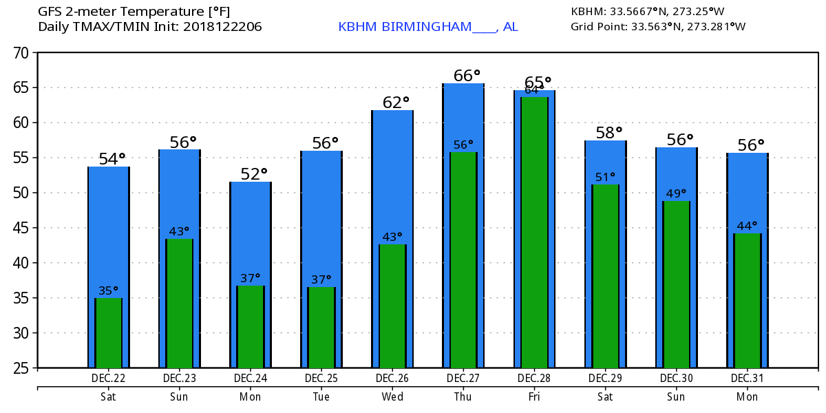
VOODOO LAND: Taking a quick peek into Voodoo Land for next weekend, we see that the GFS is keeping a chance of showers across Central Alabama on both Saturday and Sunday. It also looks like the rain chances will continue into the transition into 2019. Temperature trends show highs through the end of the year in the mid to upper 50s with lows in the mid-40s to the lower 50s.