


RADAR CHECK: Showers continue across parts of Alabama this afternoon; the sky is cloudy with temprautres mostly in the upper 40s and low 50s. Rain will end from west to east this evening as the wave in the upper atmosphere responsible for the wet weather moves on to the east.
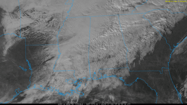
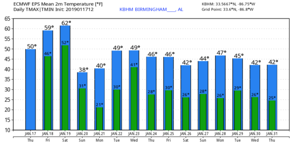
Tonight will be cloudy, and we stay above freezing with lows generally in the 40-45 degree range early tomorrow. Then, during the day tomorrow, the sky will stay mostly cloudy, but showers should be few and far between. It will be a warmer day with a high around 60 degrees.
THE WEEKEND ROLLER COASTER: A potent weather system will bring rain and thunderstorms into Alabama Saturday. It won’t rain all day, but it will rain a decent part of the day, and strong storms could be involved. SPC has defined a “marginal risk” (level 1/5) of severe thunderstorms for the southern two-thirds of the state.

This is a pretty conditional severe weather threat; there will be very little surface based instability over North Alabama. Seems like the best chance of severe storms will come over the southern half of the state, where a line of storms could produce strong gusty winds, and an isolated, short lived tornado or two. All of the state will see a good soaking, however, with rain amounts of 1 to 2 inches likely.
Saturday will be fairly mild with a high the mid 60s; and non-thunderstorm, gradient winds will average 12-22 mph out of the south/southwest.
The rain moves out Saturday night, and much colder air rolls into the state with strong northwest winds of 15-25 mph Sunday. There could be enough lingering moisture for a few snow flurries across North/Central Alabama from about midnight Saturday night through mid-morning Sunday, but we expect no accumulation or impact.
And, we should also note that we don’t expect any “flash freeze” issues with roads since strong winds and lowering dew points should help dry them quickly, and surface temperatures will be in the low to mid 30s Sunday morning.
Most communities over the northern half of the state won’t get out of the 30s Sunday, and some places across the Tennessee Valley could stay below freezing all day despite a clearing sky and afternoon sunshine. That brisk north wind will make it feel colder.
TOTAL LUNAR ECLIPSE: The sky should be clear for the lunar eclipse Sunday night (but it will be very cold!). It begins at 9:33 PM CST. A good time to watch is between 10:00 PM and 11:30 PM, the Moon will turn a reddish color as it enters Earth’s shadow.
NEXT WEEK: Monday morning will feature a clear sky, light wind, and low temperatures in the 15-25 degree range, the coldest so far this season. Then, we warm into the upper 40s Monday afternoon with a good supply of sunshine. Clouds move back into the state Tuesday, and rain is likely Tuesday night and Wednesday ahead of the wave in the upper atmosphere. More cold air rolls into the state Thursday and Friday. And, we should note we see no sign for now of any significant snow or ice issues for Alabama for the next seven days. See the Weather Xtreme video for maps, graphics, and more details.
ON THIS DATE IN 2013: One to three inches fell across the northern half of Alabama, with locally higher amounts of 4 to 5 inches also reported. Thundersnow, a very rare occurrance here in the South, was observed with the heaviest snow band as it moved across Tuscaloosa, Walker, Jefferson, and St Clair Counties. Road conditions became hazardous in areas where snow fell quickly and heavily. Icy roadways led to numerous traffic accidents in some counties, and travel came to a halt in a few locations.
BEACH FORECAST: Click here to see the AlabamaWx Beach Forecast Center page.
WEATHER BRAINS: Don’t forget you can listen to our weekly 90 minute show anytime on your favorite podcast app. This is the show all about weather featuring many familiar voices, including our meteorologists here at ABC 33/40.
CONNECT: You can find me on all of the major social networks…
Facebook
Twitter
Instagram
Pinterest
Snapchat: spannwx
I had a great time today visiting with the second graders at Crestmont Elementary in Northport… be watching for them on the Pepsi KIDCAM today at 5:00 on ABC 33/40 News! The next Weather Xtreme video will be posted here by 7:00 a.m. tomorrow…



