


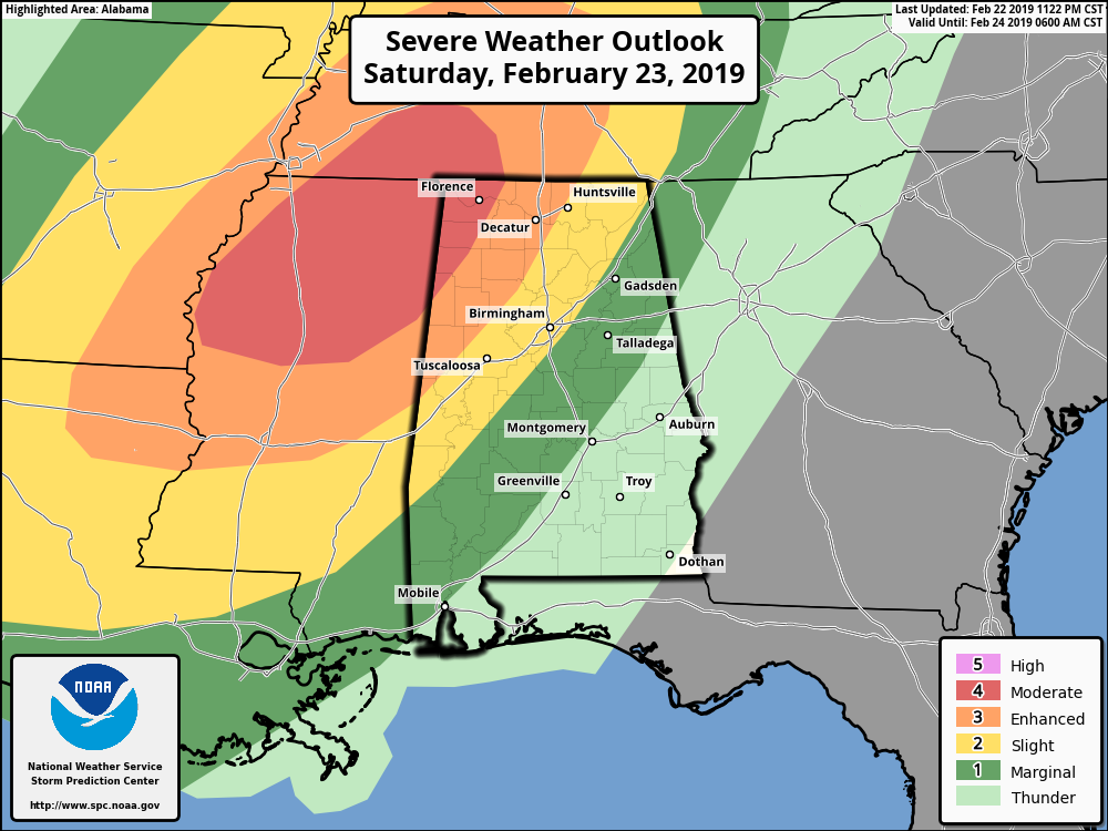
Strong to severe storms are expected across the southeast on Saturday, including damaging thunderstorm winds in excess of 60 MPH, large hail of 1 inch in diameter or more, and tornadoes (some of which could be large, long-track in nature).
The latest from the SPC has locations west of a line from Sulligent (Lamar Co.) to Hackleburg (Marion Co.) to Lexington (Lauderdale Co.) defined in a Moderate Risk of severe storms (level 4 of 5)for Saturday.
Locations east of that to a line stretching from Geiger (Sumter Co.) to Jasper (Walker Co.) to Hazel Green (Madison Co.) defined in an Enhanced Risk (level 3 of 5).
Locations east of that to a line stretching from Linden (Marengo Co.) to Pelham (Shelby Co.) to Ider (Dekalb Co.) defined in a Slight Risk (level 2 of 5).
Locations east of that to a line stretching from Hayneville (Lowndes Co.) to Alexander City (Tallapoosa Co.) to just west of Ranburne (Cleburne Co.) defined in a Marginal Risk (level 1 of 5).
Timing of the stronger to severe storms will be from 6:00 pm to 11:00 pm in the Moderate and Enhanced Risk areas, and 9:00 pm to 2:00 am in the Slight and Marginal Risk area. Once the line of storms makes it east of the risk areas, the threat of severe storms should have come to an end.
Go ahead and have your emergency plan and kit ready to go just in case your location goes under a warning. Also, have multiple ways to receive weather alerts.
We’ll keep you posted throughout the day on Saturday and through the event.



