


TODAY
While we’ll have some shower activity behind the cold front that moved through the area last night, high-pressure will start to move in our direction from the west during the day. Skies will be clearing throughout the day with afternoon highs only reaching the mid-50s to the lower 60s. Skies will be mostly clear tonight and through the overnight hours, and lows will be bottoming out in the lower 30s to the lower 40s across Central Alabama.
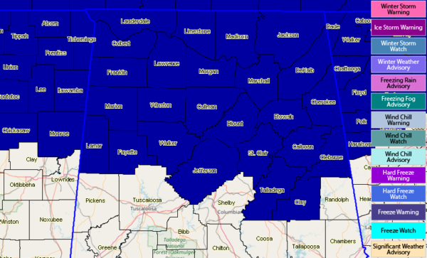
FREEZE WARNING FOR EARLY MORNING HOURS ON MONDAY
A Freeze Warning has been issued for all counties in North Alabama and for Blount, Calhoun, Cherokee, Clay, Cleburne, Etowah, Fayette, Jefferson, Lamar, Marion, St. Clair, Talladega, Walker, and Winston counties in Central Alabama starting in the overnight hours and expiring at 9:00 am Monday morning. Low temperatures are expected to fall into the upper 20 to the lower 30s in these counties.
MONDAY
We’ll have a good bit of sunshine through a good part of the daytime hours on Monday, but clouds will begin to move in late. We’ll have a chance of a few showers across the area during the evening into the late night and overnight hours, but those should be gone by just after daybreak on Tuesday. Highs will be in the upper 50s to the mid-60s.
TUESDAY
Skies will begin to clear out once again during the day on Tuesday and temperatures will start to reach the “mild category” once again. Highs will be in the 60s.
WEDNESDAY
Plenty of sunshine with a few passing clouds throughout the day on Wednesday as we continue to warm up. Afternoon highs make it up into the lower to mid-70s across the area.
THURSDAY
A low starts to build off to our northwest over Missouri on Thursday, which will fire off showers and thunderstorms throughout the afternoon and into the evening and overnight hours. At this point, it does look like any thunderstorms will be elevated as there is really no surface based instability on this model run. Afternoon highs will be back up in the lower to mid-70s.
FRIDAY
The low will move well to our north and will be over Ohio by Friday afternoon, leaving us with showers and thunderstorms likely through much of the day before moving out by the late night hours. We’ll have to watch for the potential of a few strong storms as there will be decent instability and shear in place, but it is too early to be specific on the threats. Afternoon highs top out in the mid to upper 70s.
SATURDAY
At this point, Saturday looks to be dry but getting warm for early April. We’ll have a good bit of sun with a few clouds with highs reaching the upper 70s to the lower 80s.
NEXT SUNDAY
We’ll have another low starting to develop out to our west on Sunday that may bring a chance of showers and thunderstorms back into the forecast during the afternoon and evening hours on Sunday. Models are trending for a good bit of surface based instability during the afternoon hours, so we could see some strong storms. But this is what is trending and not an official forecast as next Sunday is out there in Voodoo Land. Highs are trending in the 70s and 80s.
HONDA INDY GRAND PRIX OF ALABAMA
It’s not too late to get your tickets… The Honda Indy Grand Prix of Alabama will be April 5-7 at the beautiful Barber Motorsports Park! Make plans for the event that has been voted “Best Annual Event” & “Best Sporting Event” in Birmingham. Kids 15 & under are admitted free with a ticketed adult, and three-day general admission tickets are $69. Single day tickets are as low as $15. Pack a picnic/cooler and bring the family out for a weekend full of activities and racing! For tickets, CLICK HERE.
BEACH FORECAST CENTER
Get the latest weather and rip current forecasts for the beaches from Fort Morgan to Panama City on our Beach Forecast Center page. There, you can select the forecast of the region that you are interested in.
ALREADY OFF TO A HOT START IN 2019! ADVERTISE WITH THE BLOG!
We have enjoyed over 5.6 MILLION page views on AlabamaWx.com so far in 2019! Don’t miss out! We can customize a creative, flexible and affordable package that will suit your organization’s needs. Contact Bill Murray at (205) 687-0782.
E-FORECAST
Get the Alabama Wx Weather Blog’s Seven-Day Forecast delivered directly to your inbox by email twice daily. It is the most detailed weather forecast available in Central Alabama. Subscribe here… It’s free!
CONNECT WITH THE BLOG ON SOCIAL MEDIA
You can find the AlabamaWx Weather Blog on the major social media networks:
Facebook
Twitter
Instagram
WEATHERBRAINS
Don’t forget you can listen to our weekly 90 minute netcast anytime on the web at WeatherBrains.com or on iTunes, Stitcher, or Spotify. This is the show all about weather featuring many familiar voices, including the meteorologists at ABC 33/40.



