


“It was a dark and stormy night…” I just always line using that line on nights like this. It was the opening line to every novel that Snoopy ever started on his little typewriter on top of his dog house. A powerful grouping of storms formed over Central Louisiana during the late morning and held its intensity as it moved across Mississippi during the afternoon. The complex of storms showers overshooting tops that were seen clearly causing gravity waves atop the spreading anvil. But all in well that ends well from that system, with just a few reports of trees down in Lamar County, some golfball and half-dollar-sized hail in Winston County and plenty of lightning, 40 mph wind gusts and heavy rain to go around.
Another round of storms moved in from Mississippi during the early morning hours, but while they were loud, they were a shadow of their former self as well and heavy rain, gusty winds, and lightning were their primary calling cards.
ON THE WEATHER MAPS: The upper-level pattern across the U.S. has a split personality this morning, with the northern branch of the Jetstream all the way up in Canada. The southern branch has a huge dip in it over eastern New Mexico and western Texas. This trough will push eastward over the next 36 hours. The result will be continued unsettled conditions for Alabama.
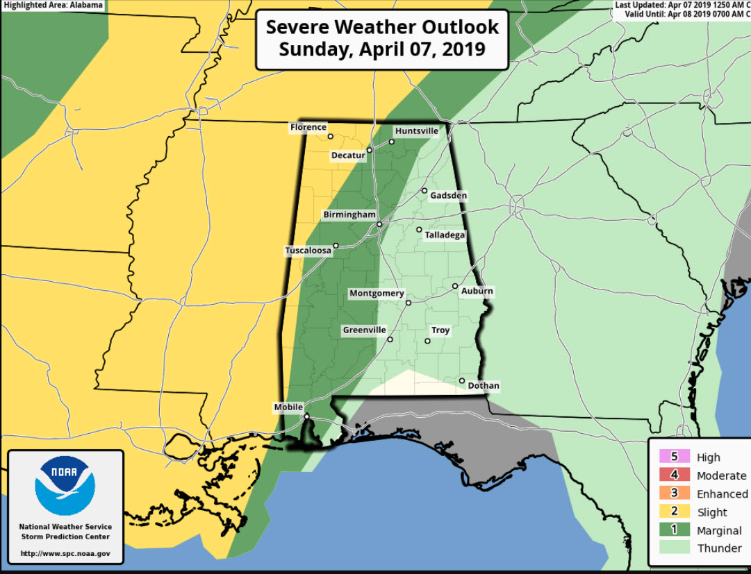
FOR YOUR SUNDAY: Skies will thin during the morning, becoming partly cloudy by noon or earlier. High temperatures will top out near 80F later today. There could be a shower or storm, especially over northwestern portions of the state, but overall, rain chances will be low today. A band of showers and storms will move into the state late tonight, likely after midnight. It will produce severe weather to the west of Alabama during the day and night tonight, but it should be weakening by the time it approaches our state. Can’t rule out a few isolated severe storms though, so be alert tonight.
HONDA WEATHER: It will be a perfect day for all the racing activities out at the beautiful Barber Motorsports Park in Leeds as the Honda Grand Prix of Alabama weekend continues. Just dress for the warmth and take the sunscreen, please. And have a great time! It’s not too late to get your tickets… Make plans for the event that has been voted “Best Annual Event” & “Best Sporting Event” in Birmingham. Kids 15 & under are admitted free with a ticketed adult. Pack a picnic/cooler and bring the family out for a day full of activities and racing! For tickets, CLICK HERE.
SEVERE THREAT ON MONDAY: A surface low is expected to form later today over southeastern Texas. This low will track slowly eastward through Monday. A band of showers and storms will push across the state during the day on Monday. Much of its transit should be during the afternoon when instabilities are traditionally the highest. Indeed, CAPE values should be over 1,500 joules/kg across the area. There should also be a decent low-level jet pushing into the state from Mississippi during the afternoon. Consequently, there could be a threat of severe weather across the state. The main threat will be damaging winds, with a more marginal threat of hail. We can’t even rule out the possibility of tornadoes. High precipitable water values will mean a decent dose of rain for much of the state. Rainfall amounts could approach 1.5-2 inches. Highs on Monday will be in the middle 70s.
TUESDAY AND BEYOND: A few lingering showers will be around early on Tuesday, and skies will be slow to clear. But highs will still reach the middle 70s. Wednesday and Thursday should be dry. Highs will return to the 80s. Welcome to spring in Alabama.
POWERFUL SURFACE LOW: By Wednesday, we will be watching a very strong surface low reach a minimum pressure of 980 millibars or so over Kansas. Strong winds will develop ahead of the system in the tight pressure gradient that will exist over the Arklamiss. You will notice the wind on Thursday. A band of storms will form near the Mississippi River Thursday and limp into Alabama early Friday. The system will be fairly moisture starved, and there shouldn’t be much in the way of strong storms.
WEEKEND OUTLOOK: Look for great weather on Friday as the weakening showers leave early setting the stage for a nearly perfect day. Same for Saturday, starting off in the lower 50s but rising into the middle 70s by afternoon. Showers could return by late Saturday night and will be likely on Sunday.
VOODOO TERRITORY: It looks like we go back into an unsettled pattern around Thursday the 18th. If the GFS verifies, a cold front will drop into the area by that Friday, but the main event may hold off til Sunday, with a chance of severe weather and heavy rains.
GULF COAST WEATHER: Storms on Monday, showers on Tuesday, but the rest of the week will be nice along the beautiful beaches of Alabama and Northwest Florida. Highs will be in the 70s to near 80F. Lows will be in the 60s. Water temperatures are warming through the middle 60s now. Click here to see the Beach Forecast Center page.
WEATHERBRAINS: This week, the panel will entertain the crew from WCBI in Columbus, Mississippi. Their station was hit by a tornado while they were live on the air earlier this year. Check out the show at www.WeatherBrains.com. You can also subscribe on iTunes. You can watch the show live at live.bigbrainsmedia.com You will be able to see the show on the James Spann 24×7 weather channel on cable or directly over the air on the dot 2 feed.
ON THIS DATE IN 2012: Snow began falling on the morning of April 6th in Anchorage AK. Nothing unusual about that. But many winter-weary Anchorage residents, who had endured double their normal snowfall total, wanted the validation of breaking the old record of 132.6 inches. It seemed the record might not fall, with no snow accumulating after mid-March, leaving the seasonal total at129.4 inches. The old record of 132.6 inches occurred in 1954-1955. But 3.4 inches fell on the afternoon of April 7th, leaving a total for the season of 133.6 inches. That made the winter of 2011-2012 is now the snowiest winter on record in Anchorage. Records have been kept at or very near the current location near the Ted Stevens International Airport since 1953. Follow my weather history tweets on Twitter. I am @wxhistorian at Twitter.com.



