


CONDITIONS AT 11:00 AM
We continue to have scattered showers and thunderstorms mainly over the eastern half of Central Alabama with the heaviest activity continuing to stay over southern parts of Cherokee County and much of Cleburne County. Flood Advisories are in effect into the early afternoon hours for parts of Jefferson, Shelby, St. Clair, Talladega, Calhoun, and Cleburne counties due to the continuous rainfall seen throughout the morning hours.
Temperatures across the area are currently in the lower 60s to the lower 70s. The cool spot is Pell City at 63 degrees with showers, while the warm spot is Tuscaloosa at 71 degrees with some sun breaking through the cloud deck.
WEATHER FOR THE REST OF YOUR TUESDAY
We’ll continue to have these wrap around scattered showers and thunderstorms throughout the remainder of the daylight hours across Central Alabama, but they will be slowly moving as a whole to the east as the low finally progresses into southern Georgia by late tonight. We should see dry conditions across all of Central Alabama by the 10 o’clock news tonight. We’ll have breaks in the clouds where it’s not raining allowing some sun to peek through at times. Afternoon highs make it up into the mid to upper 70s. Skies will clear out by the late night hours and lows will be in the lower to mid-50s for much of the area.
POSSIBLY THE WARMEST DAY OF THE YEAR SO FAR ON WEDNESDAY
Tomorrow will be a brilliant and warm day, especially for this time of April, featuring plenty of sunshine and tons of blue skies. Afternoon highs will be in the lower to mid-80s across the area. No clouds to block out the stars and the moon during the evening and overnight hours. Lows will dip down into the upper 50s to the lower 60s.
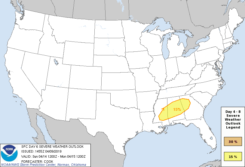
POTENTIAL FOR SEVERE WEATHER LATE INTO THE WEEKEND
The Storm Prediction Center has all of Central Alabama in a risk for severe weather in their Day 6 Severe Weather Outlook that is valid on Sunday. Usually, when the SPC has a risk out this far in advance, they have the confidence to know that the potential is there for a significant severe weather event. If you do not have a weather emergency supply kit ready to go, now is the time to make one. Have a safety plan ready to act if your location goes under a warning, and talk it over with family members to make sure they know what to do. Never rely on sirens for your source of receiving warnings. Enable the WEAs (Wireless Emergency Alerts) on your cellphones and have an NOAA WeatherRadio for the home. Be sure to read our Severe Weather Safety Guidelines page on what to do before and during a severe weather event. We’ll have updates throughout the week on this developing situation.
UPDATED ALABAMA TORNADO TOTALS FOR 2019
After adding the two Blount County tornadoes (Hayden EF0, Graves Cemetery Road EF1) and the Marshall County tornado (Collins Creek EF1) to the list, the total so far in 2019 across Alabama is up to 40 confirmed tornadoes. Here is the breakdown by strength:
EF0… 17
EF1… 17
EF2… 5
EF3… 0
EF4… 1
EF5… 0



