


…THE SEVERE THUNDERSTORM WARNING FOR SOUTHERN COLBERT…FRANKLIN
AND SOUTHWESTERN LAWRENCE COUNTIES WILL EXPIRE AT 215 AM CDT…
The storms which prompted the warning have moved out of the area.
Therefore, the warning will be allowed to expire.
A Severe Thunderstorm Watch remains in effect until 600 AM CDT for
north central and northwestern Alabama.
To report severe weather, contact your nearest law enforcement
agency. They will relay your report to the National Weather Service
Huntsville Alabama.
LAT…LON 3432 8802 3459 8805 3475 8809 3471 8760
3430 8741
TIME…MOT…LOC 0711Z 237DEG 49KT 3479 8764 3451 8753
A Severe Thunderstorm Warning Remains In Effect Until 2:15 AM CDT For Southern Colbert, Franklin And Southwestern Lawrence Counties
Jun 20th @ 1:55 am

…A SEVERE THUNDERSTORM WARNING REMAINS IN EFFECT UNTIL 215 AM CDT FOR SOUTHERN COLBERT…FRANKLIN AND SOUTHWESTERN LAWRENCE COUNTIES… At 154 AM CDT, severe thunderstorms were located along a line extending from 8 miles southeast of Cherokee to near Phil Campbell, moving northeast at 85 mph.
HAZARD…60 mph wind gusts.
SOURCE…Radar indicated.
IMPACT…Expect damage to roofs, siding, and trees. Locations impacted include… Russellville, Tuscumbia, Phil Campbell, Littleville, Belgreen, Hodges, Posey Loop, Atwood, La Grange and Tharptown.
Severe Thunderstorm Warning Issued For Parts Of Colbert, Franklin, And Lawrence Counties Until 2:15AM
Jun 20th @ 1:41 am
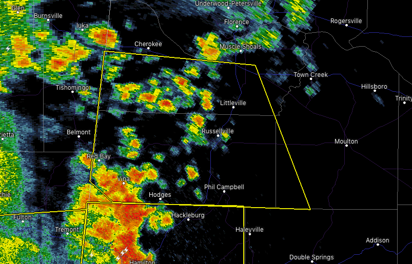

The National Weather Service in Huntsville Alabama has issued a
* Severe Thunderstorm Warning for…
Southern Colbert County in northwestern Alabama…
Franklin County in northwestern Alabama…
Southwestern Lawrence County in northwestern Alabama…
* Until 215 AM CDT.
* At 140 AM CDT, severe thunderstorms were located along a line extending from near Red Bay to near Hackleburg, moving northeast at 55 mph.
HAZARD…60 mph wind gusts.
SOURCE…Radar indicated.
IMPACT…Expect damage to roofs, siding, and trees.
* Locations impacted include…
Russellville, Tuscumbia, Red Bay, Phil Campbell, Littleville, Belgreen, Vina, Hodges, Malone and Posey Loop.



