


…THE SEVERE THUNDERSTORM WARNING FOR CENTRAL SHELBY AND EASTERN
JEFFERSON COUNTIES WILL EXPIRE AT 345 AM CDT…
The storms which prompted the warning have moved out of the area.
Therefore, the warning will be allowed to expire.
A Severe Thunderstorm Watch remains in effect until 600 AM CDT for
central Alabama.
To report severe weather, contact your nearest law enforcement
agency. They will relay your report to the National Weather Service
Birmingham.
LAT…LON 3377 8665 3377 8654 3356 8655 3330 8653
3307 8665 3307 8688
A Severe Thunderstorm Warning Remains In Effect Until 3:45 AM CDT For Central Shelby And Eastern Jefferson Counties
Jun 20th @ 3:30 am

…A SEVERE THUNDERSTORM WARNING REMAINS IN EFFECT UNTIL 345 AM CDT FOR CENTRAL SHELBY AND EASTERN JEFFERSON COUNTIES… At 329 AM CDT, severe thunderstorms were located along a line extending from Allgood to near Westover to 7 miles west of Paul M Grist State Park, moving east at 45 mph.
HAZARD…60 mph wind gusts and penny size hail.
SOURCE…Radar indicated.
IMPACT…Expect damage to roofs, siding, and trees. Locations impacted include… Northeastern Birmingham, Hoover, Vestavia Hills, Alabaster, Pelham, Mountain Brook, Trussville, Irondale, Leeds, Moody, Calera, Chelsea, Montevallo, Columbiana, Center Point, Clay, Pinson, Indian Springs Village, Westover and Wilton.
A Severe Thunderstorm Warning Remains In Effect Until 3:45 AM CDT For Shelby And Jefferson Counties
Jun 20th @ 3:16 am

…A SEVERE THUNDERSTORM WARNING REMAINS IN EFFECT UNTIL 345 AM CDT FOR SHELBY AND JEFFERSON COUNTIES… At 315 AM CDT, severe thunderstorms were located along a line extending from near Locust Fork to Oak Mountain State Park to near Marion, moving east at 45 mph.
HAZARD…60 mph wind gusts and penny size hail.
SOURCE…Radar indicated.
IMPACT…Expect damage to roofs, siding, and trees. Locations impacted include… Birmingham, Hoover, Vestavia Hills, Alabaster, Bessemer, Homewood, Pelham, Mountain Brook, Trussville, Helena, Hueytown, Gardendale, Irondale, Leeds, Moody, Calera, Fairfield, Chelsea, Fultondale and Montevallo.
The Severe Thunderstorm Warning For Perry And Bibb Counties Is Cancelled
Jun 20th @ 3:15 am

…THE SEVERE THUNDERSTORM WARNING FOR PERRY AND BIBB COUNTIES IS CANCELLED…
The storms which prompted the warning have weakened. Therefore, the warning has been cancelled. A Severe Thunderstorm Watch remains in effect until 600 AM CDT for central Alabama.
A Severe Thunderstorm Warning Remains In Effect Until 3:45 AM CDT For Shelby, Perry, Bibb And Jefferson Counties
Jun 20th @ 3:01 am

…A SEVERE THUNDERSTORM WARNING REMAINS IN EFFECT UNTIL 345 AM CDT FOR SHELBY…PERRY…BIBB AND JEFFERSON COUNTIES… At 259 AM CDT, severe thunderstorms were located along a line extending from near Blount Springs to near Bessemer to near Newbern, moving east at 45 mph.
HAZARD…60 mph wind gusts and penny size hail.
SOURCE…Radar indicated.
IMPACT…Expect damage to roofs, siding, and trees. Locations impacted include… Birmingham, Hoover, Vestavia Hills, Alabaster, Bessemer, Homewood, Pelham, Mountain Brook, Trussville, Helena, Hueytown, Gardendale, Irondale, Leeds, Moody, Calera, Fairfield, Chelsea, Fultondale and Montevallo.
The Severe Thunderstorm Warning For Southeastern Greene County Is Cancelled
Jun 20th @ 3:00 am

…THE SEVERE THUNDERSTORM WARNING FOR SOUTHEASTERN GREENE COUNTY IS CANCELLED…
The storms which prompted the warning have weakened. moved out of the warned area. Therefore, the warning has been cancelled. A Severe Thunderstorm Watch remains in effect until 600 AM CDT for central and west central Alabama. LAT…LON 3266 8747 3300 8742 3325 8707 3335 8719 3358 8717 3366 8706 3377 8702 3384 8683 3377 8654 3330 8653 3307 8665 3307 8688 3284 8688 3284 8702 3249 8711 3249 8752
A Severe Thunderstorm Warning Remains In Effect Until 3:45 AM CDT For Shelby, Perry, Southeastern Greene, Bibb And Jefferson Counties
Jun 20th @ 2:37 am

…A SEVERE THUNDERSTORM WARNING REMAINS IN EFFECT UNTIL 345 AM CDT FOR SHELBY…PERRY…SOUTHEASTERN GREENE…BIBB AND JEFFERSON COUNTIES… At 235 AM CDT, severe thunderstorms were located along a line extending from near Smith Dam to near Abernant to near Arcola, moving east at 45 mph.
HAZARD…60 mph wind gusts and penny size hail.
SOURCE…Radar indicated.
IMPACT…Expect damage to roofs, siding, and trees. Locations impacted include… Birmingham, Hoover, Vestavia Hills, Alabaster, Bessemer, Homewood, Pelham, Mountain Brook, Trussville, Helena, Hueytown, Gardendale, Irondale, Leeds, Moody, Calera, Fairfield, Chelsea, Fultondale and Montevallo.
The Severe Thunderstorm Warning For East Central Sumter County Is Cancelled
Jun 20th @ 2:36 am

…THE SEVERE THUNDERSTORM WARNING FOR EAST CENTRAL SUMTER COUNTY IS CANCELLED…
The storms which prompted the warning have moved out of the warned area. Therefore, the warning has been cancelled. A Severe Thunderstorm Watch remains in effect until 600 AM CDT for central and west central Alabama.
Severe Thunderstorm Warning Issued For Parts Of Bibb, Greene, Jefferson, Perry, Shelby, And Sumter Counties Until 3:45AM
Jun 20th @ 2:29 am
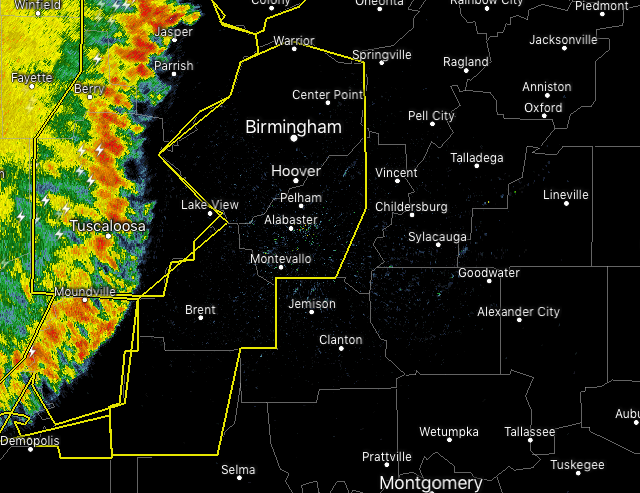

The National Weather Service in Birmingham has issued a
* Severe Thunderstorm Warning for…
Shelby County in central Alabama…
Perry County in central Alabama…
Southeastern Greene County in west central Alabama…
Bibb County in central Alabama…
Jefferson County in central Alabama…
East central Sumter County in west central Alabama…
* Until 345 AM CDT.
* At 229 AM CDT, severe thunderstorms were located along a line extending from near Curry to near Bull City to near Forkland, moving east at 45 mph.
HAZARD…60 mph wind gusts and penny size hail.
SOURCE…Radar indicated.
IMPACT…Expect damage to roofs, siding, and trees.
* Locations impacted include…
Birmingham, Hoover, Vestavia Hills, Alabaster, Bessemer, Homewood, Pelham, Mountain Brook, Trussville, Helena, Hueytown, Gardendale, Irondale, Leeds, Moody, Calera, Fairfield, Chelsea, Fultondale and
Montevallo.



