


…A SEVERE THUNDERSTORM WARNING REMAINS IN EFFECT UNTIL 300 PM CDT FOR NORTHEASTERN WALKER AND EASTERN WINSTON COUNTIES… At 239 PM CDT, severe thunderstorms were located along a line extending from near Jasper to near Inmanfield, moving east at 25 mph.
HAZARD…60 mph wind gusts and nickel size hail.
SOURCE…Radar indicated.
IMPACT…Expect damage to roofs, siding, and trees. Locations impacted include… Jasper, Arley, Addison, Curry, Smith Dam, Nesmith, Smith Lake, Brushy Lake, Helicon, Inmanfield, Sardis, Corinth Rec Area, Falls City, Houston, Mill Branch, Maple Branch, Hullett Branch, Little Dismal Creek, Bull Branch and Yellow Creek.
Severe Thunderstorm Warning Issued For Parts Of Walker And Winston Counties Until 3:00PM
Jun 22nd @ 2:22 pm
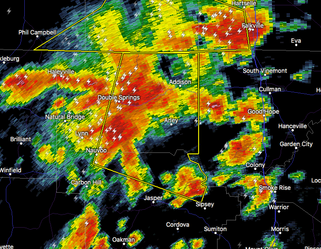

The National Weather Service in Birmingham has issued a
* Severe Thunderstorm Warning for…
Northeastern Walker County in central Alabama…
Winston County in northwestern Alabama…
* Until 300 PM CDT.
* At 222 PM CDT, severe thunderstorms were located along a line extending from Camp McDowell to Brushy Lake, moving east at 25 mph.
HAZARD…60 mph wind gusts and nickel size hail.
SOURCE…Radar indicated.
IMPACT…Expect damage to roofs, siding, and trees.
* Locations impacted include…
Jasper, Arley, Double Springs, Addison, Nauvoo, Curry, Houston
Recreational Area, Camp McDowell, Smith Dam, Nesmith, Brushy Lake, Poplar Springs, Falls City, Moreland, Smith Lake, Helicon, Inmanfield, Sardis, Corinth Rec Area and Winston Free State Barn.



