


…THE SEVERE THUNDERSTORM WARNING FOR SOUTHWESTERN CULLMAN COUNTY IS CANCELLED…
The storms which prompted the warning have moved out of the area. Therefore, the warning has been cancelled. However heavy rain is still possible with these thunderstorms. A Severe Thunderstorm Watch remains in effect until 900 PM CDT for north central, northeastern and northwestern Alabama.
A Severe Thunderstorm Warning Remains In Effect Until 3:30 PM CDT For Southwestern Cullman County
Jun 22nd @ 3:01 pm

…A SEVERE THUNDERSTORM WARNING REMAINS IN EFFECT UNTIL 330 PM CDT FOR SOUTHWESTERN CULLMAN COUNTY… At 300 PM CDT, severe thunderstorms were located along a line extending from near Hanceville to near Bangor to near Arkadelphia, moving southeast at 10 mph.
HAZARD…60 mph wind gusts and half dollar size hail.
SOURCE…Radar indicated.
IMPACT…Hail damage to vehicles is expected. Expect wind damage to roofs, siding, and trees. Locations impacted include… Cullman, Hanceville, Good Hope, Dodge City, Garden City, Colony, Phelan, Walter, Wilburn and Black Bottom.
Severe Thunderstorm Warning Issued For Parts Of Cullman County Until 3:30PM
Jun 22nd @ 2:45 pm
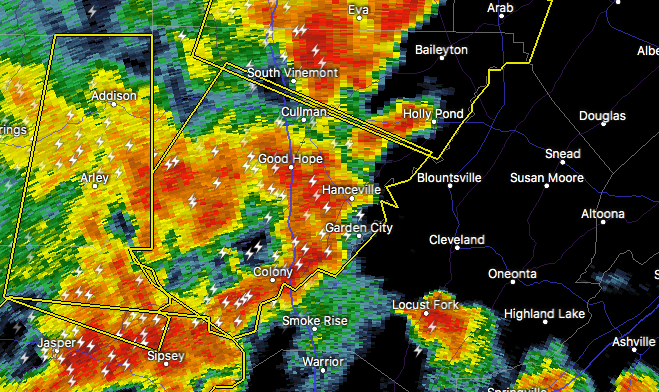

The National Weather Service in Huntsville Alabama has issued a
* Severe Thunderstorm Warning for…
Western Cullman County in north central Alabama…
* Until 330 PM CDT.
* At 245 PM CDT, a severe thunderstorm was located near Dodge City, or 12 miles south of Cullman, moving southeast at 30 mph.
HAZARD…60 mph wind gusts and half dollar size hail.
SOURCE…Radar indicated.
IMPACT…Hail damage to vehicles is expected. Expect wind damage to roofs, siding, and trees.
* Locations impacted include…
Cullman, Hanceville, Good Hope, Dodge City, Baldwin, West Point, Garden City, Colony, Phelan and Walter.



