…THE SEVERE THUNDERSTORM WARNING FOR NORTH CENTRAL JACKSON AND
SOUTHERN FRANKLIN COUNTIES WILL EXPIRE AT 615 PM CDT…
The storm which prompted the warning has weakened below severe
limits, and has exited the warned area. Therefore, the warning will
be allowed to expire. However gusty winds are still possible with
this thunderstorm.
To report severe weather, contact your nearest law enforcement
agency. They will relay your report to the National Weather Service
Huntsville Alabama.
LAT…LON 3516 8590 3499 8586 3490 8614 3509 8625
3516 8619 3518 8614 3521 8596
TIME…MOT…LOC 2311Z 311DEG 15KT 3510 8599
A Severe Thunderstorm Warning Remains In Effect Until 6:15 PM CDT For North Central Jackson And Southern Franklin Counties
Jun 22nd @ 5:58 pm

…A SEVERE THUNDERSTORM WARNING REMAINS IN EFFECT UNTIL 615 PM CDT FOR NORTH CENTRAL JACKSON AND SOUTHERN FRANKLIN COUNTIES… At 558 PM CDT, a severe thunderstorm was located over Cowan, or near Winchester, moving southeast at 15 mph.
HAZARD…60 mph wind gusts.
SOURCE…Radar indicated.
IMPACT…Expect damage to roofs, siding, and trees. Locations impacted include… Winchester, Cowan, Sewanee, Anderson, Hytop, Jericho, Maxwell, Belvidere and Sherwood.
Severe Thunderstorm Warning Issued For Parts Of Jackson And Franklin (TN) Counties Until 6:15PM
Jun 22nd @ 5:42 pm
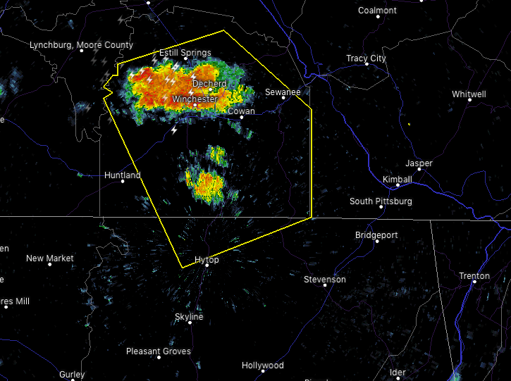

The National Weather Service in Huntsville Alabama has issued a
* Severe Thunderstorm Warning for…
North central Jackson County in northeastern Alabama…
Franklin County in Middle Tennessee…
* Until 615 PM CDT.
* At 541 PM CDT, a severe thunderstorm was located over Winchester, moving southeast at 20 mph.
HAZARD…60 mph wind gusts and penny size hail.
SOURCE…Radar indicated.
IMPACT…Expect damage to roofs, siding, and trees.
* Locations impacted include…
Winchester, Decherd, Estill Springs, Cowan, Sewanee, Tims Ford
Lake, Anderson, Hytop, Harmony and Jericho.