…THE SEVERE THUNDERSTORM WARNING FOR CENTRAL CHEROKEE COUNTY IS CANCELLED…
The storms which prompted the warning have weakened below severe limits, and no longer pose an immediate threat to life or property. Therefore, the warning has been cancelled. However heavy rain, gusty winds, and dangerous lightning are still expected with these thunderstorms. To report severe weather, contact your nearest law enforcement agency. They will relay your report to the National Weather Service
A Severe Thunderstorm Warning Remains In Effect Until 6:30 PM CDT For Central Cherokee County
Jun 27th @ 5:46 pm

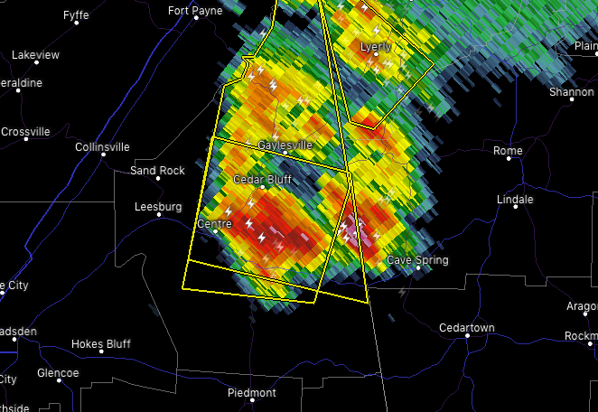
…A SEVERE THUNDERSTORM WARNING REMAINS IN EFFECT UNTIL 630 PM CDT FOR CENTRAL CHEROKEE COUNTY… At 546 PM CDT, severe thunderstorms were located along a line extending from Western Weiss Lake to near Forney, moving west at 10 mph.
HAZARD…60 mph wind gusts and quarter size hail.
SOURCE…Radar indicated.
IMPACT…Hail damage to vehicles is expected. Expect wind damage to roofs, siding, and trees. Locations impacted include… Centre, Cedar Bluff, Centre Municipal Airport, Forney, Gaylesville, Cornwall Furnace Park, Western Weiss Lake, Eastern Weiss Lake, Moshat, Howells Crossroads and Waterhouse.
Severe Thunderstorm Warning Issued For Parts Of Cherokee County Until 6:30PM
Jun 27th @ 5:34 pm

The National Weather Service in Birmingham has issued a
* Severe Thunderstorm Warning for…
Central Cherokee County in northeastern Alabama…
* Until 630 PM CDT.
* At 534 PM CDT, a severe thunderstorm was located near Forney, moving west at 5 mph.
HAZARD…60 mph wind gusts and half dollar size hail.
SOURCE…Radar indicated.
IMPACT…Hail damage to vehicles is expected. Expect wind damage to roofs, siding, and trees.
* Locations impacted include…
Centre, Cedar Bluff, Centre Municipal Airport, Forney, Gaylesville, Cornwall Furnace Park, Western Weiss Lake, Eastern Weiss Lake, Moshat, Howells Crossroads and Waterhouse.
Severe Thunderstorm Warning Issued For Parts Of Cherokee County Until 6:30PM
Jun 27th @ 5:34 pm

The National Weather Service in Birmingham has issued a
* Severe Thunderstorm Warning for…
Central Cherokee County in northeastern Alabama…
* Until 630 PM CDT.
* At 534 PM CDT, a severe thunderstorm was located near Forney, moving west at 5 mph.
HAZARD…60 mph wind gusts and half dollar size hail.
SOURCE…Radar indicated.
IMPACT…Hail damage to vehicles is expected. Expect wind damage to roofs, siding, and trees.
* Locations impacted include…
Centre, Cedar Bluff, Centre Municipal Airport, Forney, Gaylesville, Cornwall Furnace Park, Western Weiss Lake, Eastern Weiss Lake, Moshat, Howells Crossroads and Waterhouse.