WE NEED RAIN: Birmingham’s rain for the month of September so far is only 0.56″… and we have experienced measurable rain on only two days… September 11 and 14. If we don’t get any rain for the rest of the month, this will put September 2019 in the top eleven driest Septembers on record. The driest came in September 1955 when only a trace was measured. The total in September 1927 was only 0.03″, and September 1899 was 0.04″. Climatologically speaking, September is our second driest month of the year (October is the driest).
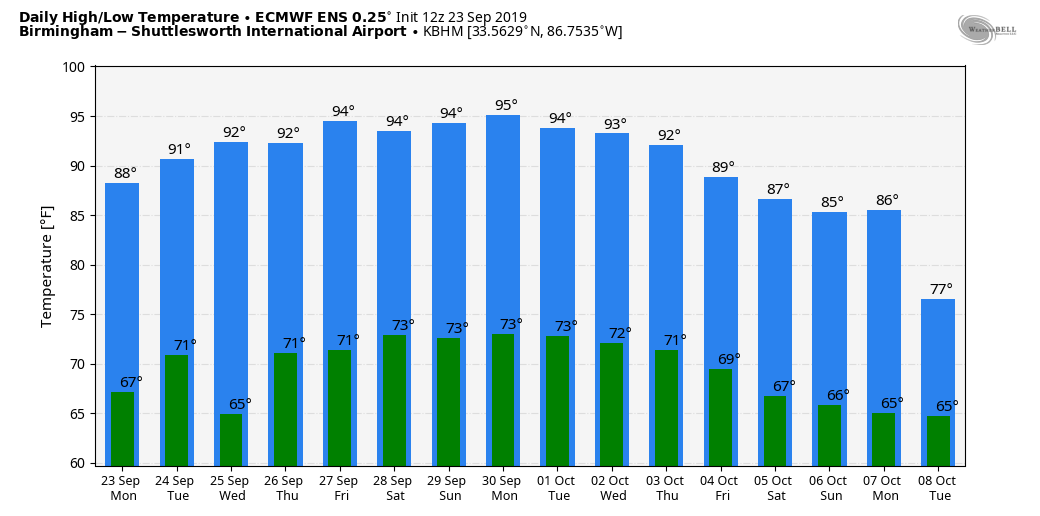
With a weak surface front in the area we will mention isolated, mostly afternoon and evening showers and thunderstorms each day for the rest of the week, but odds of any one spot getting wet are only 10-20 percent. Otherwise, look for partly sunny days with afternoon highs generally in the low 90s, about ten degrees above average for late September in Alabama.
THE ALABAMA WEEKEND: The upper ridge will strengthen, meaning hot and dry weather for the state Saturday and Sunday. Mostly sunny days, fair nights, and highs in the mid 90s, right at record levels.
NEXT WEEK: Hot, dry weather will likely continue Monday through Wednesday, but heat levels should come down a bit late in the week with some chance of scattered showers, but still not the kind of widespread, beneficial rain we need. See the Weather Xtreme video for maps, graphics, and more details.
FOOTBALL WEATHER: Mostly clear and warm for the high school games Friday night; temperatures will fall from the low 80s at kickoff into the 70s by the second half of the games.
Saturday, Alabama hosts Ole Miss at Bryant-Denny Stadium (2:30p CT kickoff)… the sky will be sunny with temperatures in the mid 90s at kickoff, falling back to near 90 by the fourth quarter.
Auburn will host Mississippi State Saturday evening at Jordan-Hare Stadium (6:00p CT kickoff)… the sky will be clear with temperatures falling from near 89 at kickoff into the low 80s by the final whistle.
UAB travels to Bowling Green to take on Western Kentucky Saturday evening (6:00p CT kickoff)… clear weather is the forecast with a kickoff temperature near 87 degrees, falling to near 80 by the fourth quarter.
Jacksonville State will also be on the road; they play Austin Peay in Clarksville, Tennessee Saturday afternoon (2:00p CT kickoff)… expect a sunny sky with temperatures in the low 90s at kickoff, falling into the upper 80s by the end of the game.
TROPICS: Three tropical storms are on the board this morning…
*Tropical Storm Jerry in the Atlantic is packing sustained winds of 60 mph, and is slowly weakening. It will pass near Bermuda tomorrow on the way eastward, away from the U.S.
*Tropical Storm Lorenzo in the eastern Atlantic is forecast to become a powerful hurricane later this week, but thankfully it will turn northward well east of the U.S.
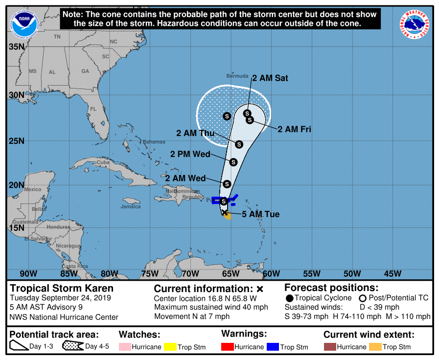
*Karen is a tropical storm again, and will move over Puerto Rico today with gusty winds and heavy rain. Sustained winds are 40 mph, and some slow strengthening is possible in coming days as it moves northward. Karen is expected to slow, and turn westward this weekend in response to a ridge north of the system, but it still remains to be seen if it will impact the Southeast U.S. Just a possibility for now.
And, a tropical wave near the northern tip of the Yucatan Peninsula will move toward the Gulf Coast of Mexico through mid-week; for now NHC gives it only a low chance of development.
ON THIS DATE IN 1939: A thunderstorm on this day dropped 6.45 inches in six hours at Indio, CA. This rainfall preceded “El Cordonazo” or “The Lash of St. Francis”, an actual tropical storm. For the entire storm, which started on this day and ended on the 26th, four inches of rain fell across the deserts and mountains as a dying tropical cyclone moved across Baja California into southwestern Arizona. This storm was the second tropical cyclone to impact California during this month. A strong El Niño may have contributed to the activity. The tropical storm produced 50 mph winds over the ocean and estimated seas of 40 feet. September rain records were set in Los Angeles with 5.66 inches and 11.6 inches at Mt. Wilson. 45 people died from sinking boats and harbors were damaged. Total damage was estimated at $2 million dollars. Californians were unprepared and were alerted to their vulnerability to tropical storms. In response, the weather bureau established a forecast office for Southern California, which began operations in February of 1940.
BEACH FORECAST: Click here to see the AlabamaWx Beach Forecast Center page.
WEATHER BRAINS: Don’t forget you can listen to our weekly 90 minute show anytime on your favorite podcast app. This is the show all about weather featuring many familiar voices, including our meteorologists here at ABC 33/40.
CONNECT: You can find me on all of the major social networks…
Facebook
Twitter
Instagram
Pinterest
Snapchat: spannwx
I have a weather program this morning for a home school group in Alexander City… look for the next Weather Xtreme video here by 4:00 this afternoon. Enjoy the day!