


The First Day Of Winter Will End Wet & Cold
A low-pressure system will begin to move up from the northern Gulf of Mexico that will push moisture up into Central Alabama. While much of us will start off dry, the rain will move up from the south and will become likely across all of Central Alabama by the late afternoon and early evening hours. While it won’t be a total washout, showers will be possible as early as wee hours of the morning on Saturday, while becoming likely for all locations in the area by the evening hours. Afternoon highs will be cool only making it into the lower to mid-50s.
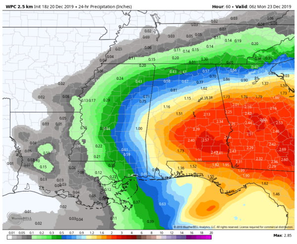
Projected rainfall totals for Sunday.
Not A Very Nice Sunday
The main low will move east-northeastward over the central parts of the Florida peninsula but a secondary low will form back off to the west over Louisiana and southern parts of Mississippi. That will begin to move across the southern parts of the area and down into South Alabama during the latter parts of the day. Rain continues to be likely throughout the entire day with highs reaching the upper 40s to the lower 50s. Rainfall amounts for the day could total from around 1/2 inch in the northwestern parts of the area to as high as 2-1/2 inches in the southeast. We may have to watch for some ponding or localized flash flooding in poor drainage locations.
Drier Weather Begins To Move Back In On Monday
That secondary low looks to continue to move across the southern portions of the state which will keep a chance of showers in the forecast through at least the early afternoon hours on Monday. After that, skies will begin to slowly clear during the evening and nighttime hours. Highs will be in the mid to upper 50s.
A Fantastic Christmas Eve
Bad news for those who want a White Christmas this year… it ain’t going to happen. On Tuesday, we’ll have plenty of sunshine with only a few passing clouds to filter out the sunshine during the late morning through the early evening hours. Afternoon highs will be in the mid-60s to the lower 70s.
Merry Christmas… Nearly Identical Weather To Christmas Eve
We’ll start off the morning with plenty of sunshine, but a few clouds will roll through the area during the late morning through the early evening hours. The GFS is hinting at the possibility of a few sprinkles out there, but I believe we will stay dry. Highs will be in the lower 60s to near 70 degrees.
Clouds At Times With Nice Temperatures To End Out The Holiday Week
The GFS continues to try to paint a few light showers or sprinkles over parts of Central Alabama on Thursday and Friday, but I believe most will stay dry with mostly cloudy skies. Highs on both days will be in the lower to upper 60s.
Beach Forecast
Get the latest weather and rip current forecasts for the beaches from Bay St. Louis, MS, to Panama City Beach, FL, on our Beach Forecast Center page. There, you can select the forecast of the region that you are interested in.
Advertise With The Blog!
After a record-setting 2018 with nearly 20 million page views, AlabamaWx.com is already well on its way to another great year as we’ve just topped 16.6 million page views so far in 2019! Don’t miss out! We can customize a creative, flexible and affordable package that will suit your organization’s needs. Contact Bill Murray at (205) 687-0782.
E-Forecast
Get the Alabama Wx Weather Blog’s Seven-Day Forecast delivered directly to your inbox by email twice daily. It is the most detailed weather forecast available in Central Alabama. Subscribe here… It’s free!
Connect With The Blog On Social Media
You can find the AlabamaWx Weather Blog on the major social media networks:
Facebook
Twitter
Instagram
WeatherBrains
Don’t forget you can listen to our weekly 90 minute netcast anytime on the web at WeatherBrains.com or on Apple Podcasts, Stitcher, or Spotify. This is the show all about weather featuring many familiar voices, including the meteorologists at ABC 33/40.



