


Non-Christmas Like Temperatures On Christmas
With the clouds being overhead on Christmas Day ending up a little thinner than thought, surface temperatures were able to be a few degrees warmer than forecast. Here is the list of high temperatures across Central Alabama:
Alexander City … 68ºF
Anniston … 68ºF
Auburn … 69ºF
Birmingham … 70ºF
Calera … 69ºF
Gadsden … 67ºF
Haleyville … 67ºF
Marion … 70ºF
Montgomery … 74ºF
Pell City … 70ºF
Selma … 70ºF
Sylacauga … 70ºF
Troy … 72ºF
Tuscaloosa’s data is not listed as the station has a malfunction causing the temperature readings to be way too warm. Didn’t hear the reason why Demopolis was missing climate data. Eufaula’s station was damaged by the tornado that hit Weedon Field March 3rd of this year.
Staying Dry Through The End Of The Holiday Work Week
A ridge of high pressure will keep us dry and in above-average temperatures throughout the day on Thursday. We’ll have some mid to high-level clouds move across the area that may filter out the sun a little, but highs should still reach the mid-60s to the lower 70s. Just a little more sunshine and temperatures could end up a degree or two warmer.
Ridging will be breaking down as moisture will begin to be pulled up from the Gulf of Mexico, but we will continue to stay dry for just one more day. Skies will be mostly cloudy with highs reaching the mid to upper 60s.
Rain Chances Ramp Up For The Central Alabama Weekend
A surface low will start off the day on Saturday over the southwestern parts of Kansas and will be moving northeast through the day. A cold front will be trailing down into the southeast from the low bringing rain chances into the forecast for late Saturday. The atmosphere will be capable of producing thunderstorms late in the evening through the overnight hours, so there may be a few scattered storms out ahead of the front. Highs will be in the upper 60s to the lower 70s.
The low will continue pushing to the northeast starting Sunday morning off in the southern parts of Minnesota and will be sliding over into Central Wisconsin by Midnight. The main line of rain and thunderstorms will be pushing into the northwestern parts of Central Alabama as early as Sunday morning and progressing across the area throughout the day. At this point, a strong storm or two may be possible, but the overall threat for severe storms is very marginal. Surface-based instability will be very small, but it doesn’t take much with the higher amounts of shear that usually occur with these winter-type systems. Rain should be out of the area by midnight. Highs will be in the lower 60s to the lower 70s.
Cooler To Start Next Week
A cooler and dry airmass will dominate the weather across Central Alabama to end off 2019 and to start of 2020. We’ll have plenty of sunshine with very little clouds on Monday and New Year’s Eve, with more clouds pushing into the area on New Years Day making skies partly cloudy. Highs will be in the 50s on all three days.
Voodoo Land
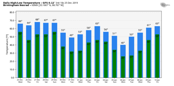
Temperatures out to the end of the forecast period on Friday, January 10th will stay relatively in the 50s and 60s for highs, but we could see a raw and blustery day on Monday, January 6th, as the high looks to be around 40 degrees. Lows throughout the period will mostly be in the 30s to the 50s, with a couple of 20s showing around January 6th and 7th. This can and probably will change as this is out in Voodoo Land.
On This Day In Weather History
1987 – Freezing rain-plagued parts of the south-central U.S., from northwest Texas to southwestern Missouri. Southwestern Missouri was turned into a huge skating rink as roads became sheets of ice. Damage to tree limbs and power lines compared to a hundred tornadoes, and half of the city of Springfield was left without electricity for 24 hours. Snow, sleet, and ice covered the northwest two-thirds of Oklahoma. 75,000 homes were left without electricity as ice accumulated one to two inches in a 40-mile band from Duncan to Norman to Tulsa to Miami. 25,000 of those homes were still without power a week later. The storm claimed the lives of seven persons (24th-27th).
Beach Forecast
Get the latest weather and rip current forecasts for the beaches from Bay St. Louis, MS, to Panama City Beach, FL, on our Beach Forecast Center page. There, you can select the forecast of the region that you are interested in.
Advertise With The Blog!
After a record-setting 2018 with nearly 20 million page views, AlabamaWx.com is already well on its way to another great year as we’ve just topped 16.6 million page views so far in 2019! Don’t miss out! We can customize a creative, flexible and affordable package that will suit your organization’s needs. Contact Bill Murray at (205) 687-0782.
E-Forecast
Get the Alabama Wx Weather Blog’s Seven-Day Forecast delivered directly to your inbox by email twice daily. It is the most detailed weather forecast available in Central Alabama. Subscribe here… It’s free!
Connect With The Blog On Social Media
You can find the AlabamaWx Weather Blog on the major social media networks:
Facebook
Twitter
Instagram
WeatherBrains
Don’t forget you can listen to our weekly 90 minute netcast anytime on the web at WeatherBrains.com or on Apple Podcasts, Stitcher, or Spotify. This is the show all about weather featuring many familiar voices, including the meteorologists at ABC 33/40.



