


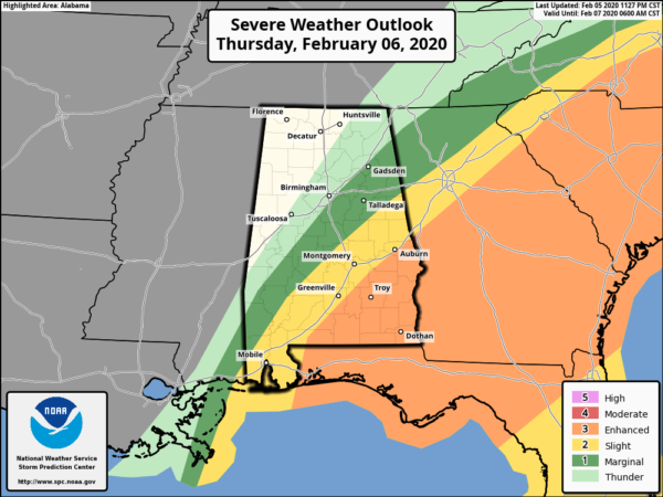
The Storm Prediction Center has an Enhanced Risk up for nearly all of the southeastern corner of Central Alabama throughout the rest of the morning to at least the midday hour on Thursday. Behind that to the west, a Slight Risk is up for locations south of a line from roughly Selma to Billingsley to Ranburne. And behind the slight and enhanced risks, a Marginal Risk is up all of the ways to the I-59 corridor in the northern half of Central Alabama stretching from Sand Rock to Hoover to Linden.
Damaging winds up to and exceeding 70 MPH and a few tornadoes will be possible from now and should be coming to an end by 12:00 pm.
Here is the text from the Storm Prediction Center…
…THERE IS AN ENHANCED RISK OF SEVERE THUNDERSTORMS FROM THE FLORIDA PANHANDLE TO NORTH CAROLINA…
…SUMMARY…
Severe thunderstorms are expected to spread from the northeast Gulf Coast this morning to the Carolinas by early evening. Damaging winds could be common with this activity, and a few tornadoes are also possible.
…Northeast Gulf Coast to the Carolinas…
Strong low-latitude trough is beginning to shift east across the Big Bend of TX/northeast Mexico as a pronounced mid-level speed max approaches the base of this feature. By mid day, 500mb speed max in excess of 100kt will translate into the lower MS Valley, then strengthen to near 140kt over the Carolinas by 27/12z. In response, intense 12hr mid-level height falls (200m) will spread across the northern Gulf States into the western Carolinas.
The low-level jet is forecast to strengthen across the northern Gulf Basin into southern AL by sunrise Thursday. This will encourage boundary-layer moistening with upper 60s surface dew points expected to advance inland across southern AL/GA, with near 70F dew points across the FL Panhandle. This moistening will be more than adequate for substantial SBCAPE ahead of the surging cold front. Latest thinking is scattered-numerous thunderstorms will be ongoing along the front at the start of the period. As large-scale forcing approaches this region, a sharpening band of frontal convection should evolve. Given the strengthening wind fields there is increasing confidence that a potentially damaging squall line will race northeast across the ENH Risk area. In addition, a few pre-squall line supercells may also develop as minimal forcing will be needed to initiate convection. Tornado threat will be most concentrated with these more discrete structures, though embedded squall-line circulations are also expected given the shear.
A well organized squall line should progress across GA/northern FL into the Carolinas during the evening hours. This linear MCS should advance off the NC Coast shortly after midnight.



