


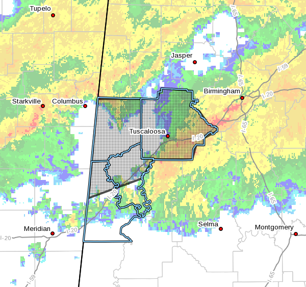
The National Weather Service in Birmingham has issued a
* Flash Flood Warning for…
Tuscaloosa County in west central Alabama…
Pickens County in west central Alabama…
Greene County in west central Alabama…
Northwestern Sumter County in west central Alabama…
* Until 615 PM CST.
* At 1215 PM CST, the public and Emergency Management reported heavy
rain and thunderstorms causing street flooding within the City of
Tuscaloosa. Radar estimates and observations of 2 to 3 inches have
occurred over the last six hours. In addition, more heavy rainfall
will move into the area from Mississippi over the next 2 to 3
hours. Flash Flooding will continue or become worse through 6pm.
HAZARD…Flash flooding caused by thunderstorms.
SOURCE…Public.
IMPACT…Flooding of small creeks and streams, urban areas,
highways, streets and underpasses as well as other
drainage and low lying areas.
* Some locations that will experience flooding include…
Tuscaloosa, Northport, Eutaw, Aliceville, Gordo, Reform,
Carrollton, Pickensville, Holt, Moundville, Lake View, Brookwood,
Coaling, Vance, Coker, Boligee, Union, Gainesville, Ethelsville and
Emelle.
PRECAUTIONARY/PREPAREDNESS ACTIONS…
Turn around, don’t drown when encountering flooded roads. Most flood
deaths occur in vehicles.
Excessive runoff from heavy rainfall will cause flooding of small
creeks and streams, urban areas, highways, streets and underpasses as
well as other drainage areas and low lying spots.
Please report flooding to your local law enforcement agency when you
can do so safely.



