


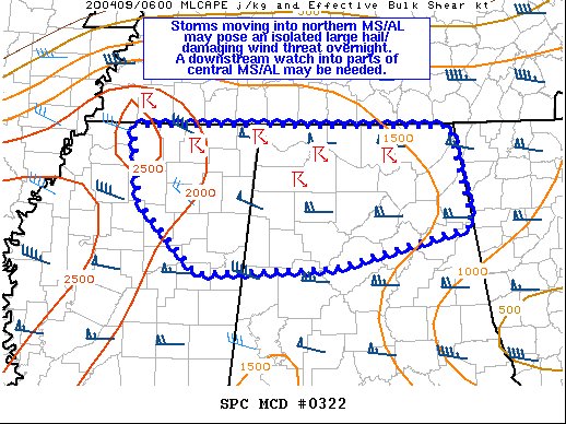
Here is the text from the latest Mesoscale Discussion from the Storm Prediction Center…
The severe weather threat for Severe Thunderstorm Watch 94 continues.
SUMMARY…
Storms moving into northern MS/AL may pose an isolated large hail and damaging wind threat overnight. A downstream watch into parts of central MS/AL may be needed.
DISCUSSION…
A couple of storm clusters moving southeastward out of southern/middle TN into northern MS/AL have recently intensified. This may be due to a modestly strengthening 40-50 kt westerly low-level jet noted on recent KGWX VWPs. A reservoir of rich low-level moisture is present ahead of this convection, with surface dewpoints generally in the mid to upper 60s. One of the storms now moving into far northwestern AL embedded within a larger cluster is exhibiting supercellular characteristics. Strengthening westerly flow through mid-levels is supporting around 50 kt of effective bulk shear. And, some modest steepening of mid-level lapse rates are still present across northern MS/AL. This suggests isolated large hail will remain possible with any supercells that can persist overnight. Otherwise, damaging winds should also be a threat with the cluster moving southeastward out of northeastern MS into northwestern and west-central AL. Depending on short term convective trends, a downstream watch into parts of northern/central MS and central AL may be needed in the next hour or so.



