


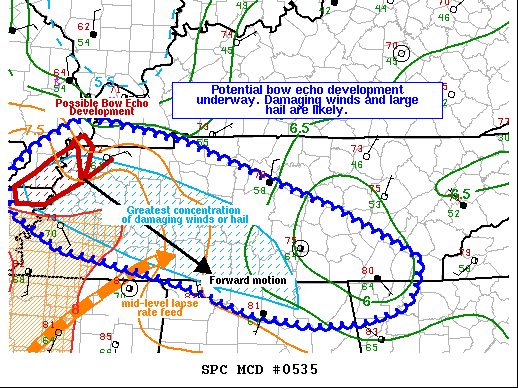
At this point, we do not know if this will be a severe thunderstorm watch (most likely) or a tornado watch, but ingredients are coming together for the potential of strong to severe storms occurring over North Alabama. Here is the latest Mesoscale Discussion from the Storm Prediction Center…
Probability of Watch Issuance…95 percent
SUMMARY…
Organized quasi-linear convection continues to grow upscale, with relatively deep moisture and instability increasing ahead of the cluster. Bow echo development is possible with this convection, with damaging winds likely. Large hail will also be a concern, and given modest backing of the surface flow, a brief tornado cannot be ruled out. A downstream WW issuance will likely be needed.
DISCUSSION…
Strong linear segments, embedded within a larger region of convection, have produced 1-1.5 inch hail within the past couple of hours. KNQA WSR-88D data also suggests that some of these storm cores are hail/graupel laden, with up to 60 dBZ echoes noted over the -20C layer. In addition, latest RAP forecast soundings indicate a relatively dry, deep layer extending from 800-600 mb, suggesting that rapid cold pool development and expansion may accompany the aforementioned convection given adequate evaporative cooling of rainwater, supported by mid-level melting of frozen graupel/hail.
Deep 925-850 mb moisture and steep mid-level lapse rates are both advecting northeastward ahead of the convection. Additional intensification of updrafts, and further evaporative cooling given the previously mentioned accompanying dry mid-level layer, will both serve to increase the damaging wind and large hail threat over the next few hours, as supported by the latest high-resolution model guidance. Given backed surface winds across portions of Middle Tennessee, a tornado or two may also occur. Severe potential is expected to continue downstream of WW 0164 as storm mergers and upscale growth continues, with a WW issuance expected shortly.



