


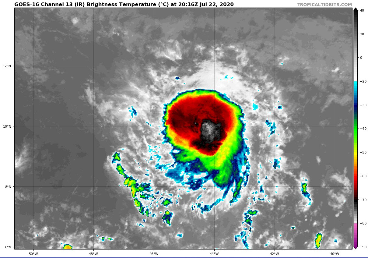
Satellite imagery this afternoon shows that the convection associated with Tropical Storm Gonzalo has really blossomed abut the storm has not strengthened…yet.
It is currently over 1,100 miles east of the islands of the Lesser Antilles.
SUMMARY OF 400 PM CDT…2100 UTC…INFORMATION
———————————————-
LOCATION…9.9N 45.0W
ABOUT 1110 MI…1785 KM E OF THE SOUTHERN WINDWARD ISLANDS
MAXIMUM SUSTAINED WINDS…50 MPH…85 KM/H
PRESENT MOVEMENT…W OR 270 DEGREES AT 14 MPH…22 KM/H
MINIMUM CENTRAL PRESSURE…1000 MB…29.53 INCHES
It is surrounded by dry air, but it has embedded itself in a nice packet of moist air that is currently protecting it. But the storm’s strengthening might end up being its demise, as a strengthening circulation could pull in the drier air.
But if an inner core to continue to form, we could see a hurricane by tomorrow.
It is being stored westward by high pressure and will impact Barbados and the southern Windward Islands Saturday, as a tropical storm, or perhaps a hurricane. The Caribbean is more hostile, with more in the way of wind shear and some of the global models predict the storm will weaken there. But some of the hurricane modes are predicting that it could hold its core together and maintaining itself.
The Canadian model brings it into the Southern Gulf of Mexico and takes it to the South Texas coast by next weekend as a hurricane.
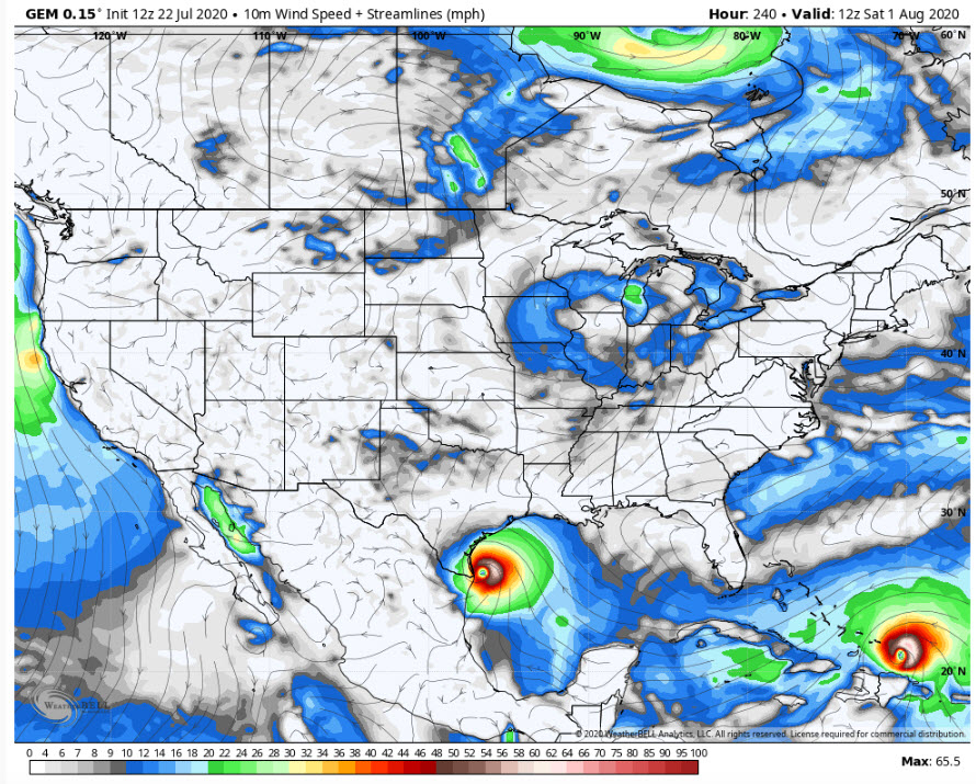
That is one possibility. Notice there is a second hurricane following on its heels over the southeastern Bahamas that would have affected Puerto Rico. That system is just getting ready to come off the African coast.
Here is the full text of the latest advisory:
BULLETIN
TROPICAL STORM GONZALO ADVISORY NUMBER 5
NWS NATIONAL HURRICANE CENTER MIAMI FL AL072020
500 PM AST WED JUL 22 2020
…GONZALO MOVING WESTWARD WITH LITTLE CHANGE IN STRENGTH DURING
THE PAST SEVERAL HOURS…
…EXPECTED TO BECOME A HURRICANE BY THURSDAY…
SUMMARY OF 500 PM AST…2100 UTC…INFORMATION
———————————————-
LOCATION…9.9N 45.0W
ABOUT 1110 MI…1785 KM E OF THE SOUTHERN WINDWARD ISLANDS
MAXIMUM SUSTAINED WINDS…50 MPH…85 KM/H
PRESENT MOVEMENT…W OR 270 DEGREES AT 14 MPH…22 KM/H
MINIMUM CENTRAL PRESSURE…1000 MB…29.53 INCHES
WATCHES AND WARNINGS
——————–
THERE ARE NO COASTAL WATCHES OR WARNINGS IN EFFECT.
INTERESTS IN THE WINDWARD ISLANDS SHOULD MONITOR THE PROGRESS OF
THIS SYSTEM.
DISCUSSION AND OUTLOOK
———————-
AT 500 PM AST (2100 UTC), THE CENTER OF TROPICAL STORM GONZALO WAS
LOCATED NEAR LATITUDE 9.9 NORTH, LONGITUDE 45.0 WEST. GONZALO IS
MOVING TOWARD THE WEST NEAR 14 MPH (22 KM/H). A GENERAL WESTWARD
MOTION AT A FASTER FORWARD SPEED IS EXPECTED DURING THE NEXT FEW
DAYS. ON THE FORECAST TRACK, THE CENTER OF GONZALO WOULD APPROACH
THE WINDWARD ISLANDS LATE FRIDAY AND SATURDAY.
MAXIMUM SUSTAINED WINDS ARE NEAR 50 MPH (85 KM/H) WITH HIGHER GUSTS.
STRENGTHENING IS FORECAST DURING THE NEXT COUPLE OF DAYS, AND
GONZALO IS EXPECTED TO BECOME A HURRICANE BY THURSDAY.
GONZALO IS A SMALL TROPICAL CYCLONE, AS TROPICAL-STORM-FORCE
WINDS EXTEND OUTWARD UP TO 35 MILES (55 KM) FROM THE CENTER.
THE ESTIMATED MINIMUM CENTRAL PRESSURE IS 1000 MB (29.53 INCHES).
HAZARDS AFFECTING LAND
———————-
NONE.
KEY MESSAGES FOR GONZALO CAN BE FOUND IN THE TROPICAL CYCLONE
DISCUSSION UNDER AWIPS HEADER MIATCDAT2 AND WMO HEADER
WTNT42 KNHC.
NEXT ADVISORY
————-
NEXT COMPLETE ADVISORY AT 1100 PM AST.
$$
FORECASTER BEVEN



