


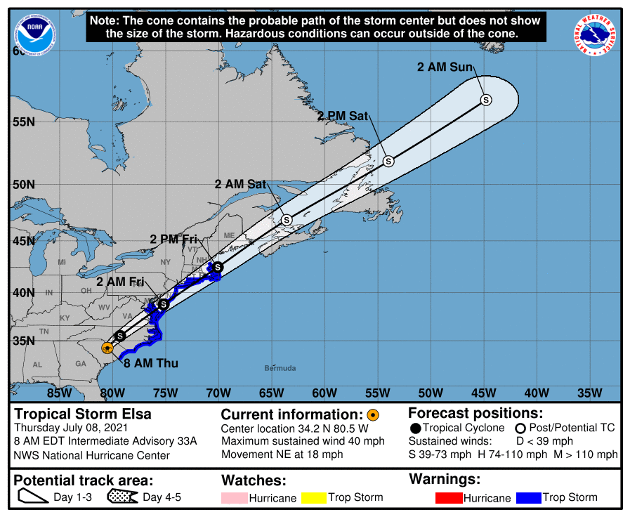
 SUMMARY OF 7 AM CDT…1200 UTC…INFORMATION
LOCATION…34.2N 80.5W
ABOUT 45 MI…70 KM W OF FLORENCE SOUTH CAROLINA
ABOUT 150 MI…240 KM SW OF RALEIGH NORTH CAROLINA
MAXIMUM SUSTAINED WINDS…40 MPH…65 KM/H
PRESENT MOVEMENT…NE OR 35 DEGREES AT 18 MPH…30 KM/H
MINIMUM CENTRAL PRESSURE…1006 MB…29.71 INCHES
WATCHES AND WARNINGS
A Tropical Storm Warning is in effect for…
* South Santee River, South Carolina, to Sandy Hook, New Jersey
* Pamlico and Albemarle Sounds
* Chesapeake Bay south of North Beach and the tidal Potomac south of Cobb Island
* Delaware Bay south of Slaughter Beach
* Long Island from East Rockaway Inlet to the eastern tip along the south shore and from Port Jefferson Harbor eastward on the north shore
* New Haven, Connecticut to Merrimack River, Massachusetts including Cape Cod, Block Island, Martha’s Vineyard, and Nantucket
DISCUSSION AND OUTLOOK
At 800 AM EDT (1200 UTC), the center of Tropical Storm Elsa was located near latitude 34.2 North, longitude 80.5 West. Elsa is moving toward the northeast near 18 mph (30 km/h), and this general motion is expected to continue with an increase in forward speed during the next couple of days. On the forecast track, Elsa will move over South Carolina and North Carolina today, pass near the eastern mid-Atlantic states by tonight, and move near or over the northeastern United States on Friday and Friday night. The system should move over Atlantic Canada by Friday night and Saturday.
Maximum sustained winds are near 40 mph (65 km/h) with higher gusts. Some re-strengthening is possible tonight and Friday while the system moves close to the northeastern United States. Elsa is forecast to become a post-tropical cyclone Friday night or Saturday.
Tropical-storm-force winds extend outward up to 115 miles (185 km) mainly over water to the southeast of the center. Myrtle Beach International Airport, South Carolina, recently reported a sustained wind of 41 mph (66 km/h) gusting to 54 mph (87 km/h).
The estimated minimum central pressure based on surface observations is 1006 mb (29.71 inches).
HAZARDS AFFECTING LAND
WIND: Tropical storm conditions are expected over portions of the South Carolina and North Carolina coasts this morning, and along the mid-Atlantic coast by this afternoon and evening. These winds will spread northward in the warning area over the northeastern states by Friday and Friday night. Non-tropical gale warnings are in effect for portions of the U. S. coast north of the Tropical Storm Warning area, and gale conditions are expected in this area late Friday and Friday night.
RAINFALL: Elsa is expected to produce the following rainfall amounts and impacts the rest of this week:
Across portions of South Carolina, storm totals of 3 to 5 inches with isolated maximum amounts up to 8 inches are likely through Thursday, which may result in limited flash and urban flooding.
Across central and eastern North Carolina into southeastern Virginia and from the Mid-Atlantic into New England…2 to 4 inches of rain with isolated totals up to 6 inches on Thursday through Friday are possible, which could result in limited-to-considerable flash and urban flooding, as well as isolated minor river flooding.
TORNADOES: A few tornadoes are possible across the eastern Carolinas into southeast Virginia through this afternoon. The threat for a tornado or two may continue tonight into Friday morning across coastal portions of the Mid-Atlantic to southern New England.
All images, forecasts, and documents are courtesy of their respective publishers.



