


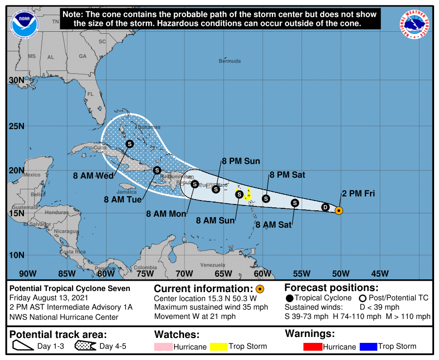
SUMMARY OF 1:00 PM CDT INFORMATION
LOCATION…15.3N 50.3W
ABOUT 775 MI…1245 KM E OF THE LEEWARD ISLANDS
MAXIMUM SUSTAINED WINDS…35 MPH…55 KM/H
PRESENT MOVEMENT…W OR 280 DEGREES AT 21 MPH…33 KM/H
MINIMUM CENTRAL PRESSURE…1010 MB…29.83 INCHES
WATCHES AND WARNINGS
A Tropical Storm Watch is in effect for…
* Antigua and Barbuda, St. Kitts and Nevis, and Montserrat
* Saba and Sint Eustatius
DISCUSSION AND OUTLOOK
At 200 PM AST (1800 UTC), the disturbance was centered near latitude 15.3 North, longitude 50.3 West. The system is moving toward the west near 21 mph (33 km/h), and this general motion with a gradual decrease in forward speed is expected into early next week. On the forecast track, the system is expected to approach the Leeward Islands on Saturday, move over the Leeward Islands Saturday night and Sunday, and then be near the Virgin Islands and Puerto Rico Sunday night and Monday.
Recent satellite-derived wind data indicate that the system remains an open wave, but maximum sustained winds are near 35 mph (55 km/h) with higher gusts. Gradual strengthening is forecast during the next couple of days, and the disturbance is expected to become a tropical storm by Saturday.
* Formation chance through 48 hours…high…80 percent.
* Formation chance through 5 days…high…80 percent.
The estimated minimum central pressure is 1010 mb (29.83 inches).
HAZARDS AFFECTING LAND
WIND: Tropical storm conditions are possible within the watch area by Saturday night or early Sunday.
RAINFALL: The system is expected to produce rainfall of 3 to 6 inches across the northern Leeward Islands Saturday into Sunday. This rainfall may produce scattered areas of flash flooding.



