


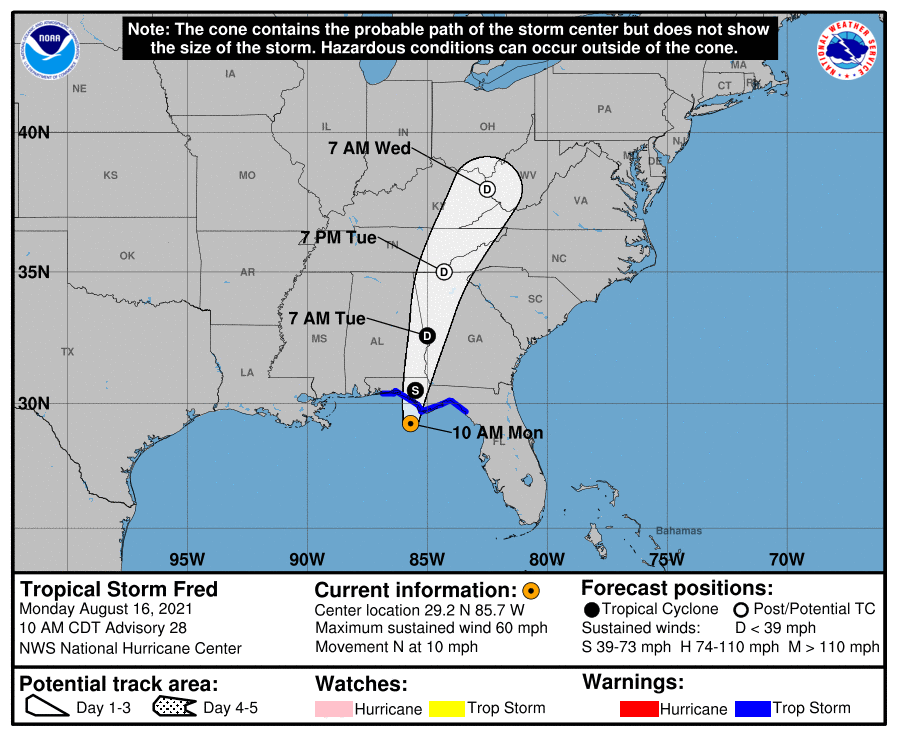
SUMMARY OF 10 AM CDT INFORMATION
LOCATION…29.2N 85.7W
ABOUT 55 MI…90 KM SW OF APALACHICOLA, FLORIDA
MAXIMUM SUSTAINED WINDS…60 MPH…95 KM/H
PRESENT MOVEMENT…N OR 10 DEGREES AT 10 MPH…17 KM/H
MINIMUM CENTRAL PRESSURE…993 MB…29.32 INCHES
WATCHES AND WARNINGS
A Storm Surge Warning is in effect for…
* Coast of Florida from Indian Pass to Yankeetown
A Tropical Storm Warning is in effect for…
* Coast of the Florida Panhandle and Big Bend from Navarre to the Steinhatchee River
FORECAST DISCUSSION
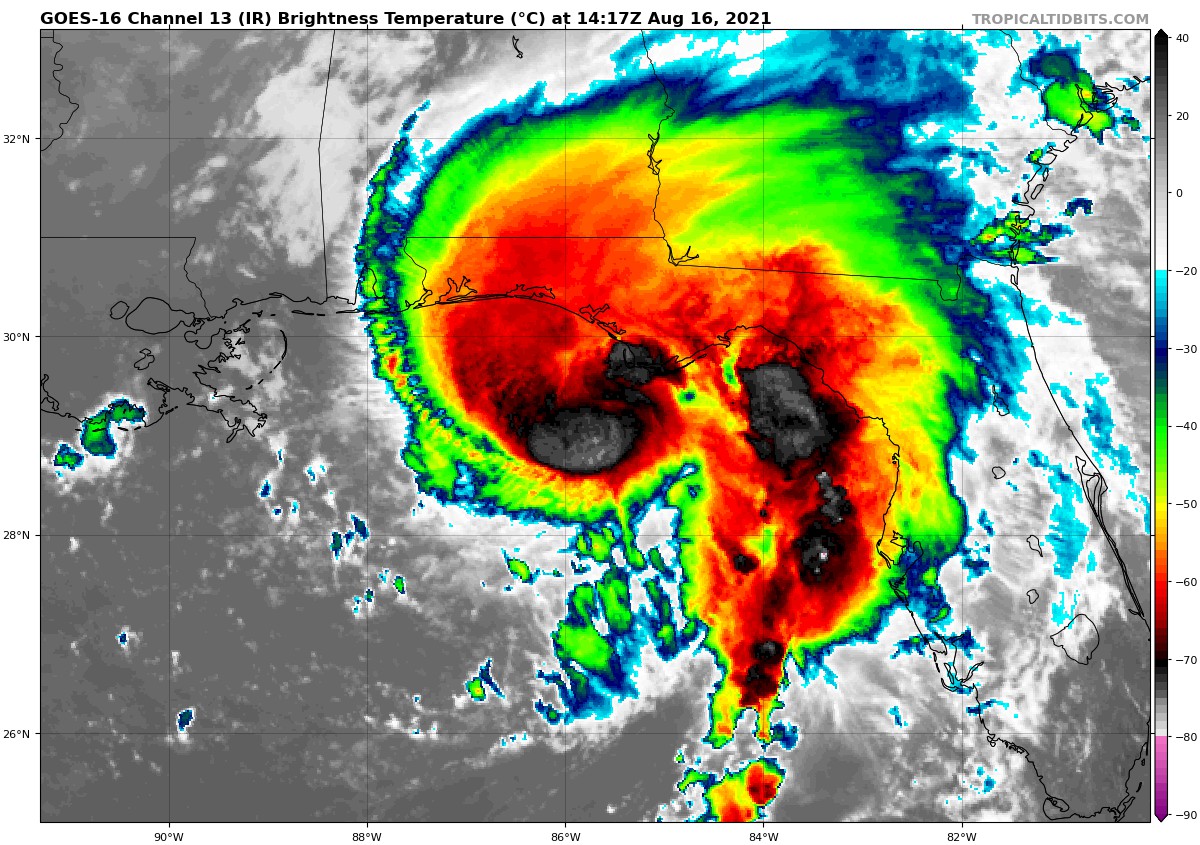
At 1000 AM CDT (1500 UTC), the center of Tropical Storm Fred was located near latitude 29.2 North, longitude 85.7 West. Fred is moving toward the north near 10 mph (17 km/h), and this general motion is expected through tonight. On the forecast track, the center of Fred should make landfall in the eastern Florida Panhandle this afternoon or early this evening, and move over western Georgia on Tuesday.
Maximum sustained winds are near 60 mph (95 km/h) with higher gusts. Some strengthening is possible before landfall. After landfall, Fred is expected to quickly weaken.
Tropical-storm-force winds extend outward up to 115 miles (185 km) from the center. A National Ocean Service observation site at Apalachicola, Florida, recently reported a wind gust of 37 mph (59 km/h). NOAA buoy 42039, located about 130 miles (215 km) south-southeast of Pensacola, Florida, recently reported a sustained wind of 56 mph (90 km/h).
The estimated minimum central pressure based on data from an Air Force Reserve Hurricane Hunter Aircraft is 993 mb (29.32 inches).
HAZARDS TO LAND
Fred is expected to produce the following rainfall amounts:
Through Monday…
Southern and Central Florida… 1 to 2 inches of additional rain, with isolated maximum storm totals of 5 inches, are expected.
Through Tuesday…
The Florida Big Bend and Panhandle… 4 to 8 inches of rain, with isolated maximum storm totals of 12 inches are expected.
Southeast Alabama through western and northern Georgia, and the western Carolinas… 4 to 7 inches of rain with isolated maximum storm totals of 10 inches are expected.
Through Wednesday…
Portions of the Mid-Atlantic States… 2 to 4 inches of rain, with isolated maximum storm totals of 6 inches expected as Fred interacts with a nearby front.
Heavy rainfall across portions of the Southeast and Mid-Atlantic States could lead to flash, urban, small stream and isolated river flooding impacts. An increased risk of landslides exists across the mountains of North Carolina, as well as portions of the Blue Ridge Escarpment, on Tuesday.
STORM SURGE: The combination of a dangerous storm surge and the tide will cause normally dry areas near the coast to be flooded by rising waters moving inland from the shoreline. The water could reach the following heights above ground somewhere in the indicated areas if the peak surge occurs at the time of high tide…
• Indian Pass, FL to Steinhatchee River, FL…3-5 ft
• Steinhatchee River, FL to Yankeetown, FL…2-4 ft
• AL/FL border to Indian Pass including Pensacola Bay, Choctawhatchee Bay and Saint Andrew Bay…1-3 ft
• Yankeetown, FL to Aripeka, FL…1-3 ft
The deepest water will occur along the immediate coast near and to the east of the landfall location, where the surge will be accompanied by large waves. Surge-related flooding depends on the relative timing of the surge and the tidal cycle, and can vary greatly over short distances. For information specific to your area, please see products issued by your local National Weather Service forecast office.
WIND: Tropical storm conditions have begun to occur in portions of the Tropical Storm warning area.
SURF: Swells generated by Fred are affecting the coasts of Mississippi, Alabama and the Florida Panhandle, and could causing life-threatening surf and rip current conditions. Please consult products from your local weather office for more details.
TORNADOES: A few tornadoes are possible today and tonight across parts of the Florida Panhandle, southwest Georgia, and southeast Alabama.



