


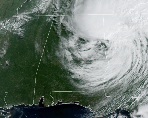
There are some lingering areas of rain across extreme East and Northeast Alabama, but as Fred has shifted over into Georgia, the weather in Alabama will not be too bad for an August day.
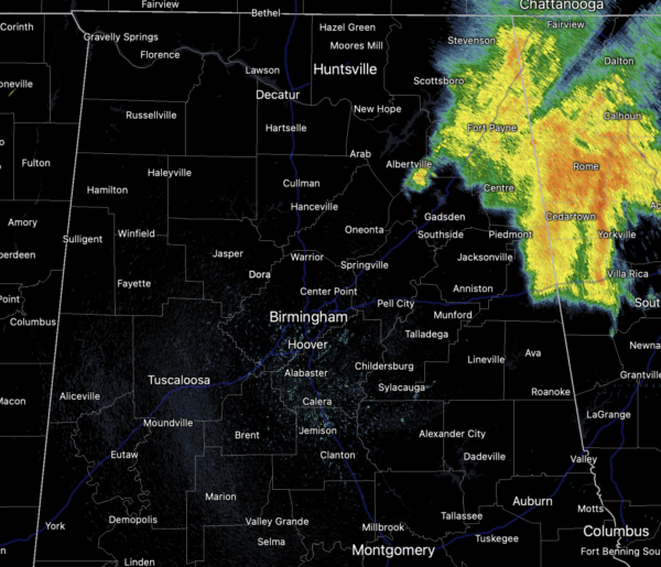
We are seeing a mix of sun and clouds and the winds continue to gust at times as well. Showers and storms, if any this afternoon will be few and far between, and temperatures are ranging from the mid-80s to low 90s across the state today.
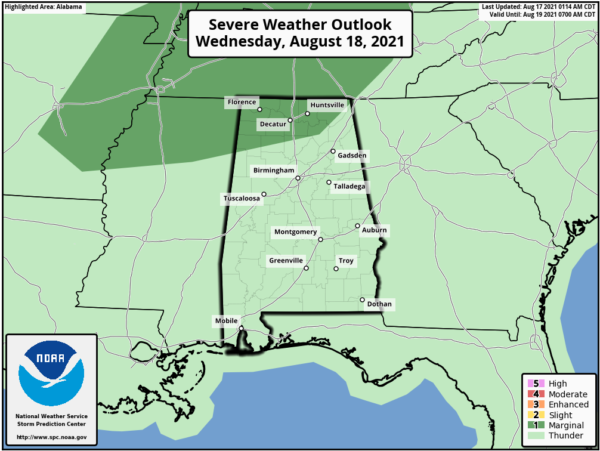
REST OF THIS WEEK: Fairly routine weather across Alabama for the second half of this week as each day will feature a mix of sun and clouds, and scattered, to perhaps numerous showers and thunderstorms, most active during the afternoon and evening hours. Rainfall could be heavy at times with a tropical air mass in place and some areas of flash flooding will be possible under the more intense tropical downpours. Also, a few strong storms will be possible, and in fact, the SPC has highlighted a chance for some strong thunderstorms over the Tennessee Valley tomorrow where a “marginal risk” (level 1/5) is in place due to the potential of strong, gusty winds.
THE ALABAMA WEEKEND: Heat levels are on the rise by the weekend as an upper ridge begins to build into the Deep South. Also, rain chances will trend downward with only scattered storms possible Saturday afternoon, but much of the state will be dry Sunday with only isolated showers. The high Saturday will be close to 90, followed by low 90s Sunday.
HOT NEXT WEEK: Mainly sunny and hot weather highlights our forecast for next week as the upper-ridge holds in place. Showers and storms will remain rather isolated, and temperatures will be in the low and mis 90s. Heat index values will likely be over 100°, and may approach the 105° Heat Advisory criteria at times.
REST OF TROPICS: Fred will dissipate over the coming days, but we are watching Tropical Storms Grace and Henri. For now, neither storm will be an issue for the U.S., but Grace will move into the southwestern Gulf by the end of the week.
TROPICAL STORM GRACE: The center of Tropical Storm Grace was located near latitude 18.3 North, longitude 76.8 West. Grace is moving toward the west near 15 mph. A general westward to west-northwestward motion is expected for the next several days. On the forecast track, the center of Grace will continue to move near the northern coast of Jamaica this afternoon. Grace is forecast to move near or over the Cayman Islands late tonight and early Wednesday, and then approach the Yucatan peninsula of Mexico late Wednesday or early Thursday.
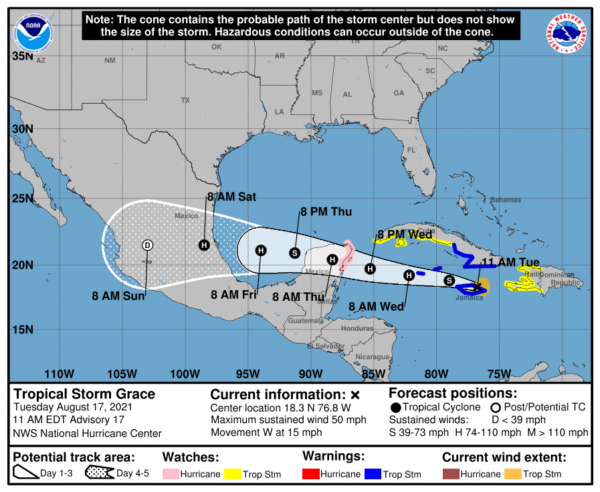
Maximum sustained winds are near 50 mph with higher gusts. Grace is forecast to strengthen into a hurricane on Wednesday, with some additional strengthening possible prior to the center reaching the Yucatan Peninsula. The estimated minimum central pressure is 1005 mb (29.68 inches).
TROPICAL STORM HENRI: The center of Tropical Storm Henri was located near latitude 30.4 North, longitude 64.3 West. Henri is moving toward the west-southwest near 6 mph. A faster motion toward the west is forecast by tonight, followed by a motion to the west-northwest or northwest by late Thursday. On the forecast track, the center of Henri should pass well to the south of Bermuda through tonight.
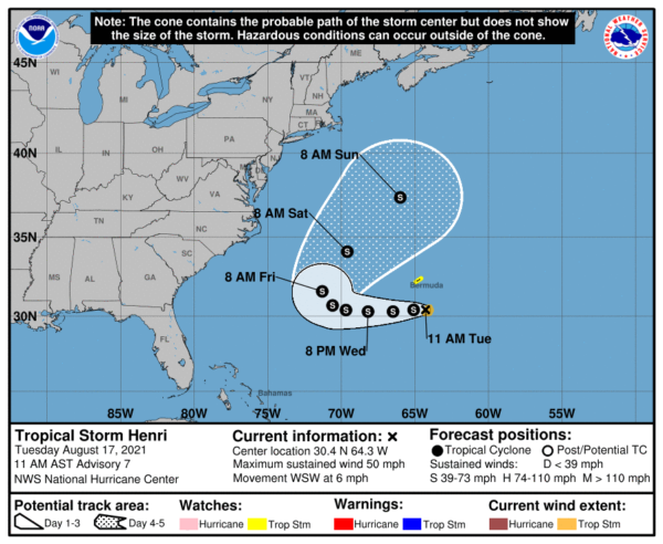
Maximum sustained winds remain near 50 mph with higher gusts. Some strengthening is possible during the next day or so. The estimated minimum central pressure is 1004 mb (29.65 inches).
BEACH FORECAST CENTER: Get the latest weather and rip current forecasts for the beaches from Fort Morgan to Panama City on our Beach Forecast Center page. There, you can select the forecast of the region that you are interested in visiting.
CONTIGUOUS TEMPERATURE EXTREMES: Over the last 24 hours, the highest observation was 120F at Death Valley and Stovepipe Wells, CA. The lowest observation was 29F at Peter Sinks, UT.



