


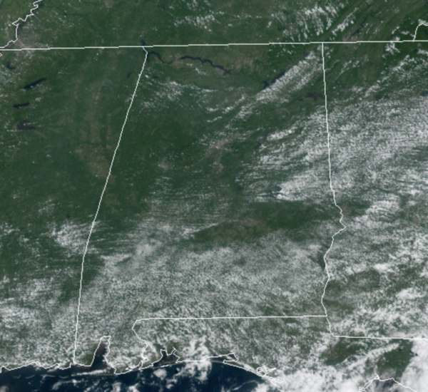
The upper ridge remains in place, but rain chances are a bit higher and this afternoon we will see some scattered showers and storms, but still these will remain widely scattered with most locations remain dry. The better rain chances today remain across South Alabama. It is another hot day with highs in the low to mid 90s. The upper ridge weakens some tomorrow and Friday, and these two days we expect an increase in the number of scattered showers and thunderstorms. Again, many locations will stay dry, while many other we will see rain. It comes down to watching radar trends during the afternoon and evening hours. Highs both days will be in the 88-92 degree range.
THE ALABAMA WEEKEND: A fairly routine late August weekend of weather for Alabama; both days should feature a partly sunny sky with those randomly scattered, mainly afternoon and evening showers and storms. Chance of any one spot seeing rain will be around 50% both days; highs this weekend will be on either side of 90°.
IN THE TROPICS: There are no other active systems in the Atlantic, but there are three areas the NHC is monitoring. The next three names are Ida, Julian, and Kate.
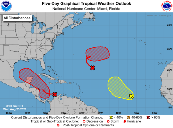
1. A broad area of low pressure is expected to form over the southwestern Caribbean Sea during the next day or so from a tropical wave currently located over northwestern Colombia and the south-central Caribbean Sea. Environmental conditions are forecast to be conducive for development, and a tropical depression is likely to form late this week or over the weekend while the system moves west-northwestward to northwestward over the northwestern Caribbean Sea. The disturbance is expected to move near or across the Yucatan Peninsula of Mexico on Saturday, and move into the western Gulf of Mexico by Sunday where conditions could be favorable for additional development to occur. Formation chance through 5 days…high…80 percent. This feature is one we will have to watch because the models bring this system in the Gulf of Mexico, with the higher landfall probabilities along the upper Texas/western Louisiana coasts Monday. But, this could easily change over the next few days. No way of knowing the intensity at this point; we will be watching model trends closely.
2. A broad trough of low pressure is producing disorganized showers and thunderstorms over the central tropical Atlantic about 800 miles southeast of Bermuda. Only slow development of this system is expected during the next day or so due to unfavorable upper-level winds. Afterwards, environmental conditions are forecast to become more conducive for development, and a tropical depression is likely to form late this week or this weekend while the system turns eastward over the central Atlantic. Formation chance through 5 days…high…80 percent.
3. A tropical wave over the far eastern tropical Atlantic located several hundred miles southwest of the Cabo Verde Islands is producing a disorganized area of showers and thunderstorms. Some development of this system is possible over the next several days while it moves west-northwestward at 10 to 15 mph over the eastern tropical Atlantic. Upper-level winds are forecast to become less conducive for development by this weekend. Formation chance through 5 days…low…30 percent.
BEACH FORECAST CENTER: Get the latest weather and rip current forecasts for the beaches from Fort Morgan to Panama City on our Beach Forecast Center page. There, you can select the forecast of the region that you are interested in visiting.
WORLD TEMPERATURE EXTREMES: Over the last 24 hours, the highest observation outside the U.S. was 120.6F at Semawa, Iraq. The lowest observation was -98.9F at Amundsen-Scott South Pole Station, Antarctica.
CONTIGUOUS TEMPERATURE EXTREMES: Over the last 24 hours, the highest observation was 112F at Death Valley, CA. The lowest observation was 21F at Stanley, ID.
WEATHER ON THIS DATE IN 1940: New Jersey experienced its coldest August morning of record, with lows of 32 degrees at Layton and Charlotteburg.



