


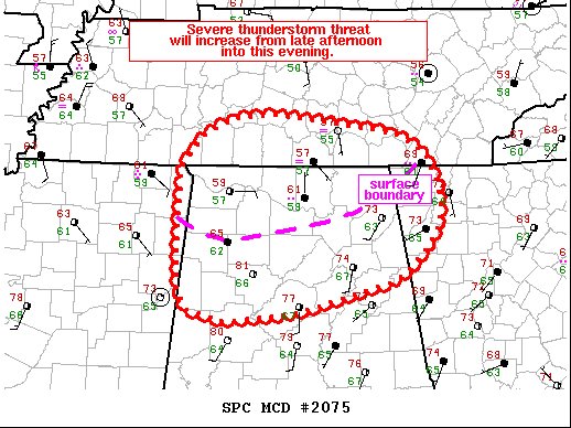
The Storm Prediction Center has released a Mesoscale Discussion for the northern half of North/Central Alabama and states that conditions will favor damaging wind gusts and a few tornadoes. A watch is likely to be issued within the next 2-3 hours. Here is the text of the discussion:
SUMMARY… Severe thunderstorm potential will increase from late afternoon into this evening. Timing of watch issuance remains uncertain, but may be needed within the next 2-3 hours.
DISCUSSION… Airmass recovery slowly continues this afternoon across parts of northern AL in the wake of morning/early afternoon showers. A surface boundary related to this earlier precipitation extends west to east from roughly Haleyville AL into far northwest GA. Some additional destabilization is expected with northward extent across the MCD area in a sustained warm advection regime through the evening hours. However, the latest hi-res guidance continues to indicate some uncertainty in regard to the northward extent of severe potential, as well as in timing of the severe threat. Most guidance, along with observational trends, preclude discrete warm sector development in deference to an eastward-advancing, and currently developing, bow/QLCS in the vicinity of the Mississippi River/western TN/northwest MS as of 2030z/230pm CST. The best estimate of severe storms moving into the MCD area is between 22-00z.
Once storms do emerge over the region, a strong low-level jet and bowing segments will favor damaging gusts, with a few mesovortex tornadoes possible as well. Convective trends will continue to be monitored, as a watch will likely be needed for portions of the MCD area in the next 2-3 hours.



