


That was one heckuva storm that pummeled the Northeast yesterday. 23.7” of snow at Boston, rivaling the 27” in the great Blizzard of 1978. 22.4 inches of snow at Islip on Long Island. Snowfall rates reached 4 inches per hour in some spots. Winds gusting over 30 mph across a wind area, with a 63 mph gust measured at Beverly, Mass. Coastal flooding was both immense and widespread. The low-pressure system that started intensifying off the coast of North Carolina Friday night bombed out to at least 979 millibars. Frigid air filtered in on the backside of the departing low, with readings below zero across parts of Pennsylvania, New York, Vermont, New Hampshire, and Maine.
CHILLY HERE TOO: Temperatures early on this Sunday morning are generally between 25-30F across North and Central Alabama under crystal clear skies. Winds will continue to be gusty out of the west and southwest for much of the day. Highs this afternoon under clear skies should reach into the 50s and lower 60s.
NEW WORK WEEK: High pressure will build back in behind the departing trough and this will allow for milder temperatures for much of the workweek. We will reach into the 60s each day. Lows Monday morning will be near or below freezing, warming into the upper 30s Tuesday morning, 40s Wednesday morning, and 50s Thursday morning. Rain will arrive Wednesday, lingering into Thursday. Ice won’t be very far to our northwest, coming as close as western Tennessee up into the Ohio Valley, but for us, it will be all rain.
WEEKEND OUTLOOK: The rain should mainly be gone by Friday, but things will turn colder again. Weekend highs will be around 50F, with lows in the 30s Friday morning, 20s Saturday morning, and 30s Sunday morning. Rain could return as early as late Saturday night, becoming likely on Sunday. But lots of disagreement and uncertainty concerning the return of precipitation.
ICE STORM TO OUR NORTHWEST? Ice may be a problem by midweek in areas to the west and northwest of Alabama, especially over the Ohio Valley with a good bit of snow in the colder air over the Midwest.
BEACHCAST: Looks like the beautiful beaches of Alabama and Northwest Florida will stay dry till late Thursday into early Friday. Highs will be in the 60s until Friday, with 50s for the weekend. Lows will be in the 40s and 50s all week, with 30s by the weekend.
Click here to see the Beach Forecast Center page.
DANCING WITH THE STATS: Atlantic City broke their record snowfall AND rainfall records for the date with 14.0 inches and 1.46 inches respectively.
ADVERTISE WITH US: Deliver your message to a highly engaged audience by advertising on the AlabamaWX.com website. The site enjoyed over 29 MILLION page views in the past 12 months. Don’t miss out! We can customize a creative, flexible, and affordable package that will suit your organization’s needs. Contact me, Bill Murray, at (205) 687-0782, and let’s talk.
WEATHERBRAINS: This week, the panel will entertain Dr. Lori Peek from the Natural Hazards Center. Check out the show at www.WeatherBrains.com. You can also subscribe on iTunes. You can watch the show live at live.bigbrainsmedia.com or on James’ YouTube Channel You will be able to see the show on the James Spann 24×7 weather channel on cable or directly over the air on the dot 2 feed.
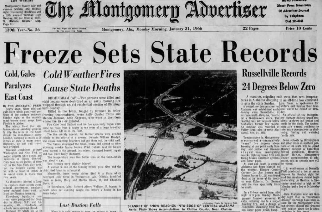
ON THIS DATE IN 1966: Alabama’s coldest temperature ever (-27F) was measured at New Market in Northeast Madison County about 25 miles northeast of Huntsville. The reading was recorded under clear skies with light winds and 12 inches of snow on the ground, perfect for extremely cold weather. This broke the previous state record of -18F at Valley Head, which was measured on February 14, 1905. Other lows on this frigid morning: -24F at Russellville, -17F in Haleyville, -12F at Redstone Arsenal, -11F in Valley Head. In the Birmingham area, it aw -4F at the Airport, -5F in Pinson, and -2F in Bessemer. In South Alabama, it was 9F in Fairhope and Bay Minette, 13F in Mobile, 14F at Fort Morgan, 5F at Montgomery and Selma. It was 0F as far south as Clanton. The same storm dumped heavy snow across other parts of Alabama, including 11 inches at Moulton, 8 inches at Hamilton, Scottsboro, Cullman, and Red Bay; 7 inches at Huntsville, Guntersville, Double Springs, and Russellville and 6 inches at Jasper, Falkville and Albertville. Mississippi also recorded their state all-time record low on this date with -19F at Corinth. Follow my weather history tweets on Twitter. I am @wxhistorian at Twitter.com



