


Saturday was a nice but cold day across North and Central Alabama. Highs across North Central Alabama included 45F at Anniston and Birmingham and 47F at Tuscaloosa. Overnight lows were in the lower 20s North to middle and upper 20s Central, under mostly clear skies.
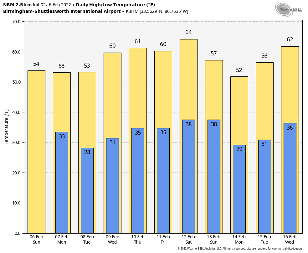
FOR YOUR SUNDAY: After this chilly start, a southeasterly wind will help to warm temperatures about 10 degrees over those of yesterday. This will allow highs to rise into the lower 50s North and middle 50s Central. Skies will become partly cloudy. Tonight, lows will range from the upper 20s to the lower 30s.
ON THE WEATHER MAPS: Weak high pressure covers Alabama this morning, with a weak shortwave passing out of the southern part of the state. A bigger trough will be developing to our west over the next day or so. This trough will pass without much notice because of an ample supply of dry air. Another stronger trough will follow it on Wednesday and Thursday. But it will bring the same dearth of precipitation that the first two bring. What it will be able to bring is a continual supply of dry and cool air. Highs will be in the 50s with lows in the 30s through Thursday.
WEEKEND OUTLOOK: Lots of uncertainty in the weekend forecast. The GFS has been more and more aggressive with a mix of cold and precipitation. The noon run yesterday depicted a quick-hitting glance of snow down into North and North Central Alabama. The morning run of the European was in pretty fair agreement. Will that pan out? Neither model was too bullish on accumulations though. We will just have to wait and see.
STRONG SYSTEM ON THE 17TH: The GFS is back to giving a severe weather look with this system. This one is a long way off, but it does bear watching.
BEACHCAST: A benign week of weather along the beautiful beaches of Alabama and Northwest Florida. There could be a few light showers Sunday night, but otherwise dry and cool, just like here. Highs will be in the 50s and lows in the 30s and 40s through midweek. Highs will edge by in the 60s just in time for the weekend. Water temperatures are in the middle 50s.
Click here to see the Beach Forecast Center page.
DANCING WITH THE STATS: It was 22F at Victoria, TX, 24F at Laredo and Corpus Christi yesterday morning, all records for the date. Freeze warnings continue
ADVERTISE WITH US: Deliver your message to a highly engaged audience by advertising on the AlabamaWX.com website. The site enjoyed over 28 MILLION page views in the past 12 months. Don’t miss out! We can customize a creative, flexible, and affordable package that will suit your organization’s needs. Contact me, Bill Murray, at (205) 687-0782, and let’s talk.
WEATHERBRAINS: This week, the panel will entertain Dr. Kandis Boyd, a pioneering meteorologist. Check out the show at www.WeatherBrains.com. You can also subscribe on iTunes. You can watch the show live at live.bigbrainsmedia.com or on James’ YouTube Channel You will be able to see the show on the James Spann 24×7 weather channel on cable or directly over the air on the dot 2 feed.
ON THIS DATE IN 1980: 20 inches of snow fell at Elizabeth City NC as pasts of Virginia and North Carolina were buried by a strong winter storm. Norfolk VA set its record for the biggest snowstorm ever with 12.4 inches. Follow my weather history tweets on Twitter. I am @wxhistorian at Twitter.com.



