


YESTERDAY: Saturday was a fairly nice day across the area. With a good supply of sunshine. But a cold front moved almost imperceptibly across the area during the day. Most of North Central and South Central Alabama warmed into the 60s and 70s, but deeper in the cold air, the Tennessee Valley remained in the 50s all day. The high at Muscle Shoals was only 51F while at Montgomery, it was73 for the daytime max. Some clouds and a few sprinkles and snow flurries moved into Northwest Alabama after dark, but the precipitation diminished soon after that. Temperatures have fallen quickly overnight, into the lower and middle 20s Northwest and Tennessee Valley with upper 20s and lower 30s across the rest of South Central Alabama in the lower and middle 30s.
FOR YOUR SUNDAY: Despite near-total sunshine, the mercury will struggle to get out of the 40s over the northern half of the area. South Central Alabama stations will reach 50F. It may be breezy at tomorrow, as northerly winds freshen behind a secondary cold front that will deliver only drier air. Lows tonight will be mostly in the 20s.
NICE START TO THE WEEK: The first half of the new week will feature dry conditions with a warming trend. Highs will warm from the 50s Monday, to the 60s for Tuesday and Wednesday. Some locations will approach 70F on Wednesday. Lows will be near freezing Tuesday morning but be back in the 40s for Wednesday morning.
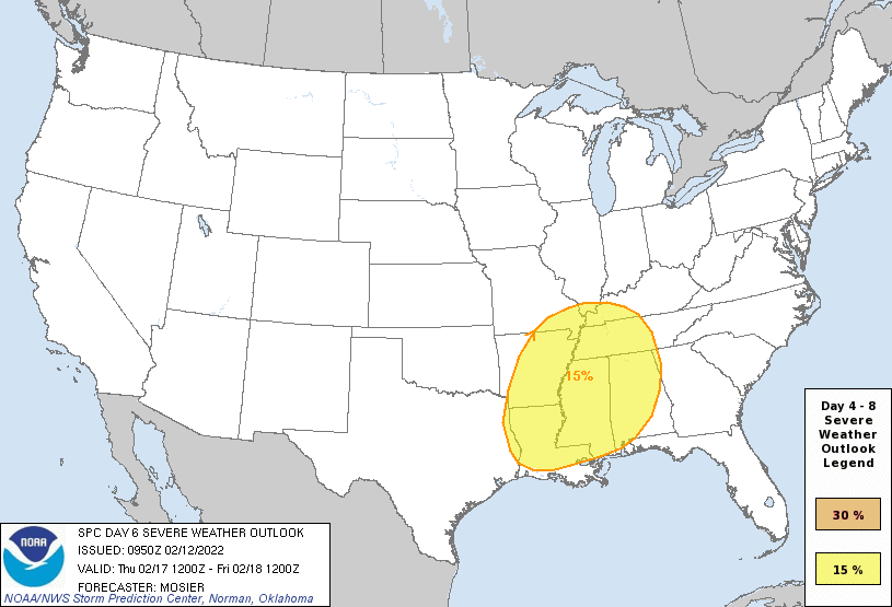
DYNAMIC STORM SYSTEM THURSDAY: Lots of unanswered questions as to the severe weather threat for Thursday. The signals are there: strengthening low pressure moving from Oklahoma to western Kentucky by Thursday morning, a strong upper trough approaching from the west, and a cold front pushing to the southeast. Temperatures are expected to rise into the upper 60s to lower 70s Thursday, with dewpoints reaching 65F across much of the area. Regulars on here know that that spells trouble. The temperatures, dewpoints, and upper trough indicate instability will be present, and with the strong wind field, severe storms look likely. Low-level helicity would also be fairly prevalent, causing the concern for tornadoes. But the amount of instability, the time of day factor, and the potential lack of forcing make it less than a done deal. Still, it is a great time to do the mental gymnastics of reviewing your personal severe weather safety plan just in case.
WEEKEND OUTLOOK: Clearing and cooler weather for Friday and Saturday. Rain could return Sunday.
BEACHCAST: Chilly through midweek, then rain and storms Thursday, with clearing for the weekend until rain returns Sunday. Click here to see the Beach Forecast Center page.
NATIONALLY: Winter Weather Advisories and even one Winter Storm Warning for the Mid-Atlantic into the Northeast today. Many areas picking up an inch or two of snow, with some getting in excess of four inches.
DANCING WITH THE STATS: 89F at LAX and UCLA yesterday both broke records for the date by one degree. It will be close to the hottest Super Bowl ever there today, as the forecast is for 82F today. The hottest Super Bowl was also in LA, in 1973.
ADVERTISE WITH US: Deliver your message to a highly engaged audience by advertising on the AlabamaWX.com website. The site enjoyed over 29 MILLION page views in the past 12 months. Don’t miss out! We can customize a creative, flexible, and affordable package that will suit your organization’s needs. Contact me, Bill Murray, at (205) 687-0782 and let’s talk.
WEATHERBRAINS: This week, the panel will entertain Mike Bettes and his wife Allison Chinchar. The show will be recorded on Tuesday. Enjoy your Valentine’s Day on Monday. Check out the show at www.WeatherBrains.com. You can also subscribe on iTunes. You can watch the show live at live.bigbrainsmedia.com or on James’ YouTube Channel You will be able to see the show on the James Spann 24×7 weather channel on cable or directly over the air on the dot 2 feed.
ON THIS DATE IN 1899: A blizzard dubbed the “Storm King” culminated the week of intense cold that had engulfed the eastern half of the country. The Storm King spread a wide swath of snow from Florida to Maine. New York City already had 11 inches of snow on the ground when the snow began on February 13th. New York City picked up 15.6 inches of snow as the Storm King held sway. The heavy snowfall was accompanied by temperatures near zero. Follow my weather history tweets on Twitter. I am @wxhistorian at Twitter.com.



