


ENDING OFF THE WORKWEEK
The low that has been bringing us rain and storms over the past few days begins to slowly move off to the northeast. While we may not see any sunshine today, the good news is that rain chances will be lowered. Everyone will have a chance of scattered showers and storms, but the higher chances will be over the east and southeastern parts of the area. Highs in the upper 70s to the mid 80s.
The low will be out of the area on Friday, but we’ll continue to see some lingering effects. There is only a small chance of scattered showers and storms over the eastern half of Central Alabama, while the western half remains dry. Highs in the 80s.
THIS WEEKEND
Saturday looks to be the best day of the forecast period as it will feature plenty of sunshine, but the heat begins its return as highs top out in the upper 80s to the lower 90s.
Sunday shows a return of scattered showers and storms, especially during the late afternoon through the evening hours. Highs in the upper 80s to the lower 90s.
MONDAY-WEDNESDAY
Rain and storms return on Monday as we settle back into a northwesterly flow. It will also be hot as highs reach the upper 80s to the lower 90s.
On Tuesday, much of the area will be dry and hot, but we can’t rule out an isolated shower or storm during the first half of the day. Highs in the upper 80s to the lower 90s.
And at the end of the forecast period on Wednesday, we’ll have mainly sunny skies with highs in the upper 80s to the mid 90s.
THE TROPICS
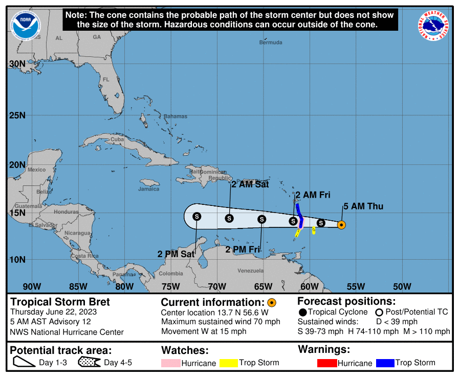
We have Tropical Storm Brett approaching the Leeward Islands with maximum sustained winds at 70 mph and a minimum central pressure of 996 millibars. Hurricane watches and tropical storm warnings are up for the islands, as Brett will bring strong wind and heavy rain today and tonight. Weakening is anticipated to begin tonight or Friday after Bret passes the Lesser Antilles, and the system is likely to dissipate over the central Caribbean Sea by Saturday night.
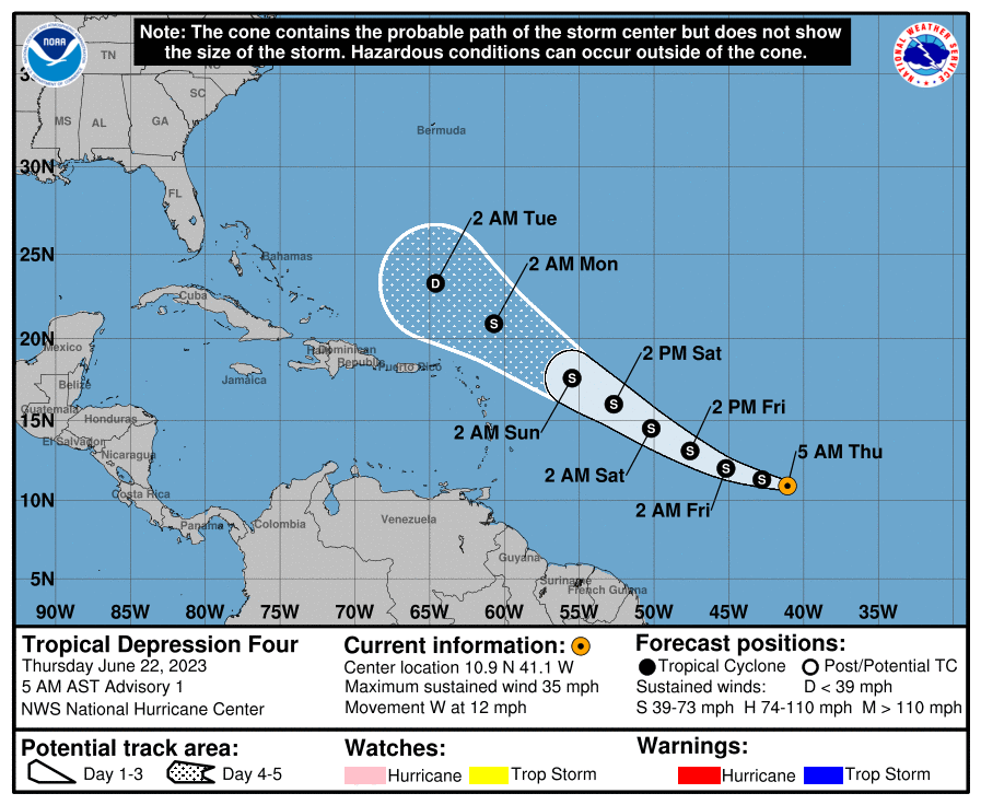
Tropical Depression Four formed earlier this morning just behind Brett, but it will be taking a more northwesterly track. Gradual strengthening is expected over the next few days, but increasing wind shear will weaken it by Monday or Tuesday. Models have been consistent in showing TD4 curving to the north well before the US mainland.
BEACH FORECAST CENTER
Get the latest weather and rip current forecasts for the beaches from Dauphin Island, AL, to Panama City Beach, FL, on our Beach Forecast Center page. There, you can select the forecast of the region that you are interested in.
ON THIS DAY IN WEATHER HISTORY
1886 – A destructive hurricane hit the Apalachicola – Tallahassee area of Florida on the summer solstice. Extensive damage was done in Florida and throughout the Southeast by this storm. Damage was due mainly to extremely high tides.
ADVERTISE ON THE BLOG!
Don’t miss out! We can customize a creative, flexible, and affordable package that will suit your organization’s needs. Contact Bill Murray at (205) 687-0782.
E-FORECAST
Get the Alabama Wx Weather Blog’s Seven-Day Forecast delivered directly to your inbox by email twice daily. It is the most detailed weather forecast available in Central Alabama. Subscribe here… It’s free!
CONNECT WITH THE BLOG ON SOCIAL MEDIA
You can find the Alabama Wx Weather Blog on Facebook and Twitter.
WEATHERBRAINS
If you are crazy about weather, this is THE podcast for you! Listen to the latest released episode each Tuesday, or catch up on any episodes that you have missed. The WeatherBrains crew includes your host, James Spann, plus other notable geeks like Troy Kimmel, Bill Murray, Rick Smith, James Aydelott, Jen Narramore, Dr. Neil Jacobs, and Dr. Kim Klockow-McClain. They bring together a wealth of weather knowledge and experience for another fascinating podcast about weather. Available at WeatherBrains.com, or on Apple Podcasts, Google Podcasts, Spotify, or Stitcher.



