


Get ready for an impressive sight tonight as a supermoon rises in the southeast sky this evening at 6:39 p.m. It will become full early Monday morning, around 6:38 a.m. It will be equally brilliant Monday evening when it rises at 7:50 p.m. This month’s full moon is also called the Buck Moon, for the male deer which is growing antlers at this time of year. Of course, all this is dependent on the sky being clear enough to permit the moon to be seen. Fingers crossed.
CONGRATULATIONS STALLIONS: Hooray for our hometown Birmingham Stallions who won their second consecutive USFL Championship in Canton, Ohio with an impressive victory over the Pittsburgh Maulers.
HOTTEST DAY OF THE YEAR: Saturday was the hottest day of 2023 across parts of Alabama Saturday, including Birmingham, where it reached 98 degrees. Tuscaloosa reached 97F and Anniston 96F. Dothan and Troy checked in 99F. Gulf Shores was the state’s hot spot, with 100F. Now that’s unusual.
ALL THAT HEAT LED TO…some strong and severe storms. Many strong storms were able to form on the stovetop that was Alabama yesterday. Winds gusted to 85 mph at Decatur and there were numerous reports of wind damage including trees down (some on homes) in various areas. There was some hail as well. As much as three inches of rain fell in St. Clair County in just one hour, but there were no significant reports of flooding. The storms began to die down during the late afternoon and were mostly gone by 10 p.m.
ONE MORE VERY HOT DAY: We should manage to push high temperatures well into the 90s again today. Heat index values will rise into the 105-110F range which is prompting heat advisories for all of North and Central Alabama. Much like yesterday, clusters of storms will begin forming by noon and will push slowly eastward while gradually raining themselves out. Some of those storms will be strong to severe across all of North and Central Alabama. The best chance of severe weather will be in the border counties between Alabama and Tennessee. Damaging winds from microbursts will be the biggest threat, but there could be some hail, and there will certainly be heavy rain and deadly lightning.
THE HOLIDAY WEEK: The ridge that was been building into the Southeast will be weakening and barely a shadow of its former self as we go into Monday. A train of shortwave disturbances will be flowing through a channel to our north through the Ohio Valley. The first of those is to our northwest this morning. A cold front extends from Indianapolis to Little Rock to North Texas. A warm, moist airmass covers the Deep South and will remain entrenched in coming days. As disturbances flow through the upper flow, and daily heating energizes the atmosphere, this same pattern of fairly numerous showers and storms will develop each day. Temperatures will ease back into the lower 90s Monday and fall back into the upper 80s to near 90F the rest of the week. Lows will be in the lower 70s.
WEEKEND OUTLOOK: The front may eventually work its way into South Alabama by Saturday and Sunday, perhaps giving a little break to North and Central Alabama.
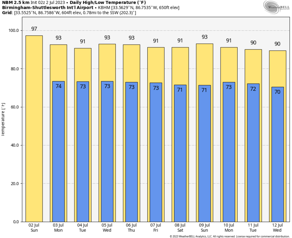
WEEK TWO: Another front tries to settle into Alabama early in the second week. Big high pressure tries to develop over the Ohio Valley late in the week. Alabama is on the southern side of the ring of fire. That just means more showers and storms. Temperatures are right around normal, highs near 90F, lows in the lower 70s.
BEACHCAST: Thunderstorms will be a daily feature along the beautiful beaches of Alabama and Northwest Florida during this holiday week ahead. It will be hot and humid as well, with highs in the lower 90s, with lows in the middle 70s. Water temperatures are in the lower 80s. Low rip current risk for the week ahead, with surf running about 1 foot. That’s good news given the recent tragic death toll along the beaches.
Click here to see the Beach Forecast Center page.
TROPICAL WEATHER: Nothing looks threatening in the Tropical Atlantic right now. Neither the GFS or the European show anything developing over the next 10 days, but the 18z GFS did come up with a new idea that a tropical storm will spin up over the northwestern
NATIONAL NOTES: Heat continues to be the story nationally with heat advisories covering the South and the West Coast. Severe weather is possible today from the Mid South to the Mid-Atlantic.
DANCING WITH THE STATS: A few additional reports of hail 2 inches or larger in diameter on Friday closed out what was an amazing month of June for large hail. There was even a report of 4” hail in Wabaunsee County, Kansas Friday evening. It may end up being a record number of large hail reports for any June. At last report it was only second to June 2004. There were also plenty of reports of giant hail (5” or larger) including hailstones in Mississippi and Louisiana during the month that were nearly state records.
ADVERTISE WITH US: Deliver your message to a highly engaged audience by advertising on the AlabamaWX.com website. We have a lot of big plans for this year. Don’t miss out! We can customize a creative, flexible, and affordable package that will suit your organization’s needs. Contact me, Bill Murray, at (205) 687-0782 and let’s talk.
WEATHERBRAINS: This week, the panel will entertain SEC Commissioner Greg Sankey and his daughter Hannah Strong. Hannah is a television meteorologist in Louisville. Check out the show at www.WeatherBrains.com. You can also subscribe on iTunes. You can watch the show live on our new YouTube channel for the show.You will be able to see the show on the James Spann 24×7 weather channel on cable or directly over the air on the dot 2 feed.
ON THIS DATE IN 1916: The following warning was issued by the U.S. Weather Bureau Central Office in Washington:
Tropical disturbance central short distance north of Swan Island, approximately latitude 17 north, longitude 84 west; apparently moving north or northwest.
The Weather Bureau Office in Mobile disseminated the bulletin to the press and it was published in the Mobile Register. The early season hurricane would make landfall on the evening of the 5th near Gulfport, Mississippi. It produced a 12 foot surge at Mobile. Winds gusted to 106 mph at Mobile and 104 mph at Pensacola. As the hurricane moved up into southern Mississippi, it weakened and steering currents collapsed. The remnants would drift slowly north and then eastward over the next five days, producing torrential rains and flooding over Mississippi and Alabama. Birmingham established a 24 hour rainfall record that would stand until 2004. Follow my weather history tweets on Twitter. I am @wxhistorian at Twitter.com.



