


The upcoming week in Alabama will feature a mix of sunny skies and occasional clouds, with a few scattered thunderstorms expected. As Tropical Storm Debby makes its way across the Gulf of Mexico, most impacts will stay east of Alabama, but we should stay alert to any changes in its track. Temperatures will range from the lower 90s to the upper 90s, with heat indices potentially making it feel even hotter.
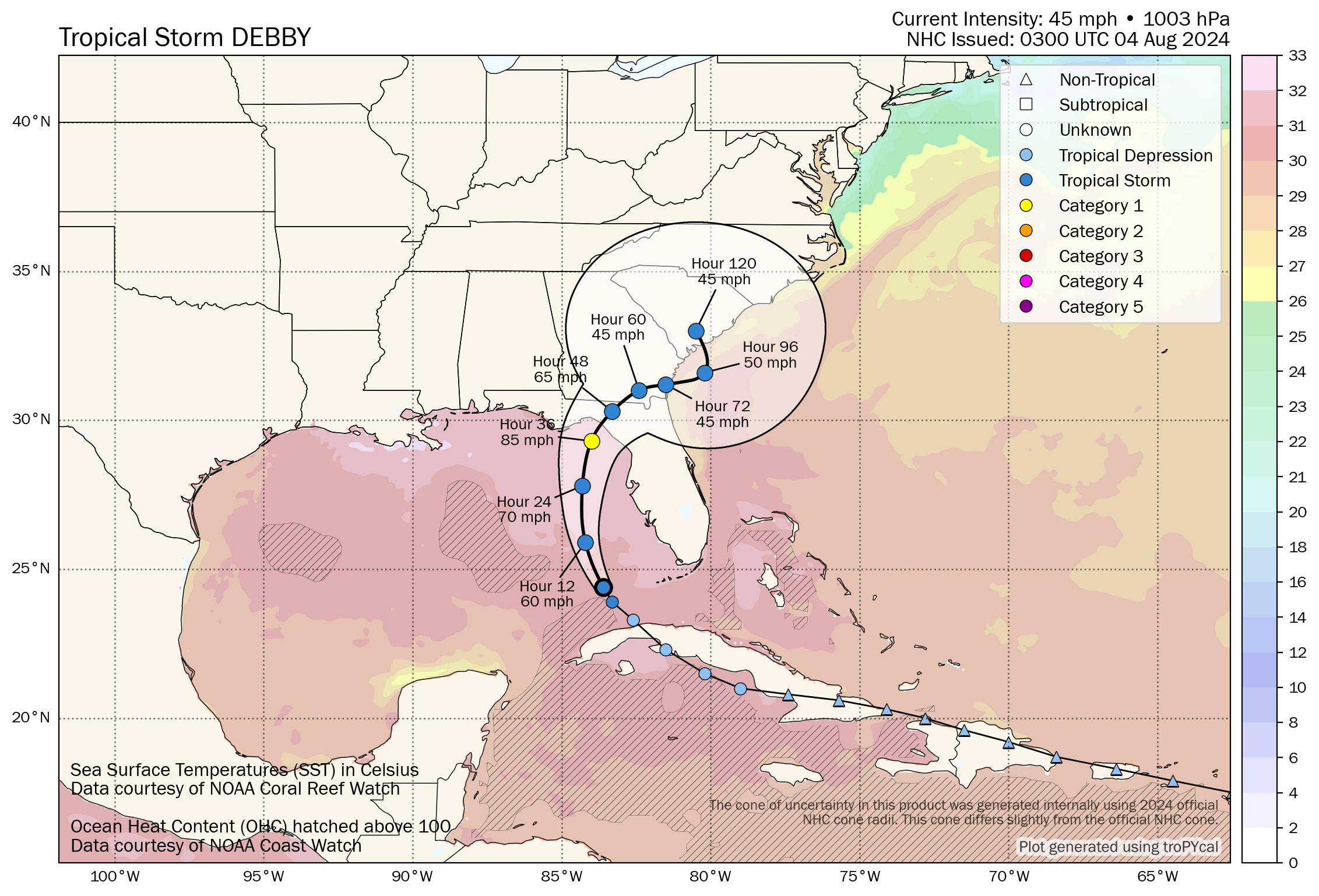
TROPICAL STORM DEBBY WILL BECOME HURRICANE DEBBY
Tropical Storm Debby is currently making its way across the southeastern Gulf of Mexico and is expected to strengthen as it moves towards the Florida coast. Forecast models indicate that Debby could reach hurricane strength before making landfall, likely in the Big Bend area of Florida, late Sunday night or early Monday. The National Hurricane Center has issued various warnings and watches, including a Hurricane Warning from the Suwannee River to the Ochlockonee River and a Storm Surge Warning for the coastal areas from Aripeka to Indian Pass. Residents in these areas should prepare for potentially dangerous conditions, including strong winds, heavy rainfall, and significant storm surge.
As Debby progresses, it will bring tropical storm conditions to much of the Florida Peninsula and possibly to parts of the southeastern United States. The storm is expected to produce 6 to 12 inches of rainfall, with isolated totals up to 18 inches, which could lead to considerable flash and urban flooding. There is also a risk of tornadoes, particularly in the Florida Keys and the western Florida Peninsula. While Alabama is not expected to experience the brunt of the storm, residents should remain vigilant and prepared for any indirect impacts, such as increased cloud cover and a slight uptick in humidity. The situation remains fluid, and updates will be crucial as Debby continues to develop.
After making landfall in the Big Bend area of Florida, Tropical Storm Debby is expected to move northeastward across northern Florida and into southeastern Georgia. By Tuesday, the system is forecast to re-enter the Atlantic Ocean, where it could potentially re-strengthen. As Debby moves over the warm waters of the Atlantic, there’s a possibility it could regain some intensity, with models suggesting it may track along the coastlines of Georgia and the Carolinas. This renewed strength could bring additional heavy rainfall, strong winds, and dangerous surf conditions to coastal areas. Residents along the Southeast coast should closely monitor Debby’s progress, as the storm’s path and intensity could change, posing further threats to those regions into midweek.
ALABAMA IMPACTS
Debby will combine with the front to our South to bring a few showers to the Wiregrass region of Southeast Alabama late Sunday into Monday. Winds could gust to 20-25 mph over the southeastern quarter of the state.
SUNDAY
Expect mostly sunny skies with highs reaching the lower 90s. A stationary front will linger in the area, primarily impacting the southeastern part of the state with a slight chance of showers and thunderstorms. Winds will be light and variable, mostly from the northeast, providing little relief from the heat. Overnight lows will dip into the lower 70s, making for a warm and muggy night.
SUNDAY NIGHT & MONDAY
Monday will be another warm day with mostly sunny conditions and a slight chance of afternoon showers and thunderstorms, particularly in the southeastern counties. Highs will again reach the lower 90s, with some areas possibly feeling like the mid-90s due to the humidity. The evening will be mostly clear, with temperatures falling into the mid-70s.
MIDWEEK OUTLOOK
Tuesday and Wednesday will be the hottest days of the week, with highs soaring into the mid to upper 90s. The heat index could approach 105°F on Wednesday, making it feel very hot and uncomfortable. A strong high-pressure system will dominate, bringing mostly sunny skies and keeping rain chances low. Overnight lows will remain in the mid-70s, continuing the trend of warm nights.
LATE WEEK & WEEKEND
It looks like the remnants of Debbie may move back into Alabama from the east on Thursday and Friday bringing rain and storms that will linger into Saturday. Winds will be gusty on Thursday, but no significant impacts are expected.
VOODOO COUNTRY
The week two period looks dry, but a second tropical system which is aimed toward Texas could recurve towards Alabama and the Deep South around teh end of week two or around Friday the 16th.
WEATHERBRAINS THIS WEEK
This week’s WeatherBrains podcast will feature meteorologist Dr. Sam Lillo, who will discuss Tropical Storm Debby’s developments and potential impacts. The episode will also cover the broader outlook for the hurricane season and recent weather patterns affecting the United States. Tune in for expert insights and engaging discussions on the latest in meteorology.
BEACH WEATHER
For those heading to Alabama’s Gulf Coast beaches, expect mostly sunny skies with highs in the lower 90s. The water temperature is in the upper 80s, perfect for swimming. However, be cautious as there is a moderate to high risk of rip currents starting Sunday night and continuing through Tuesday, influenced by Tropical Storm Debby’s presence in the Gulf. Winds will be light to moderate, primarily from the northeast and shifting to the northwest as the week progresses.
WEATHER HISTORY
On August 4, 2022, a tragic event occurred when four people were struck by lightning in Lafayette Park near the White House during an afternoon thunderstorm. A couple from Wisconsin, aged 76 and 77, passed away due to the strike. This incident marked the first lightning fatalities in Washington D.C. since 1991, highlighting the dangers of severe weather and the importance of seeking shelter during thunderstorms.



