


Daily Briefing
Sunday, December 7, 2025
ALABAMA YESTERDAY
Saturday was a cool, gray day across Alabama, with stubborn cloud cover and pockets of light rain drifting through at times. Temperatures stayed well below normal for early December, holding in the 40s across the north and barely nudging into the low 50s farther south. The damp air and limited sunshine kept things feeling chilly throughout the afternoon, before skies cleared, setting the stage for the widespread fog that developed overnight.
ALABAMA THIS MORNING
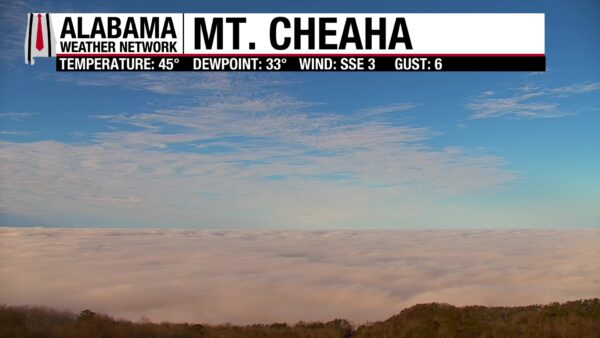
A thick blanket of fog has settled over parts of Alabama this morning, with visibility dropping to near zero in spots across central parts of the state. A Dense Fog Advisory is in effect until 10 AM for a broad stretch of central Alabama, where both advection fog from the south and radiational fog in the north have combined into a widespread low-visibility setup. Travel will be slow going early on, and conditions may not improve much until midmorning as the low clouds begin to lift.
SPANN SKYWATCHERS
A foggy, chilly Sunday morning greeted Skywatchers across Alabama, with reports of freezing fog in the north and thick low clouds from the Tennessee Valley to the Birmingham metro.
Sandra Kirkwood – New Market – 28° (freezing fog)
Vic Bell – Randolph County – 28° (freezing fog)
Daniel Harbin – Trenton – 30° (dense fog)
Jeff Lee – Carbon Hill – 32°
Chris Cheatwood – Anniston (McClellan) – 36°
Andy Klein – Helena – 43°
Join the team! Learn how to become a Spann Skywatcher: https://www.spannskywatchers.com/
YOUR ALABAMA WEATHER
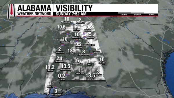
FOG AND LOW CLOUDS THIS MORNING
Widespread fog developed overnight, and dense fog remains possible through mid-morning across much of the state. Some freezing fog may linger in the northeast where early temperatures dip near freezing. Visibility will gradually improve late this morning as low clouds begin to lift.
DRIZZLE AND CLOUDS THROUGH THE AFTERNOON
Most of Alabama stays cloudy today, with highs reaching the lower 50s north and mid-50s to near 60 farther south. A push of low-level moisture could bring areas of drizzle or very light rain at times, though many places see long dry stretches. Expect a cool, gray day statewide.
SUNDAY NIGHT: LIGHT RAIN EDGES BACK IN
A passing upper disturbance and colder air aloft will bring increasing chances for light rain tonight, beginning in north Alabama and drifting southward. Rainfall amounts remain light, but wet roads are likely by daybreak Monday. Lows fall into the upper 30s north and lower to mid-40s central and south.
MONDAY: TURNING SHARPLY COOLER
A cold front moves through early Monday, ending lingering showers and ushering in much colder, drier air. Highs stay in the upper 40s to lower 50s. Monday night drops well below freezing across the Tennessee Valley and into the low 30s central Alabama, with upper 30s near the Gulf Coast.
TUESDAY THROUGH THURSDAY: A BRIEF MIDWEEK WARMUP
Sunshine returns Tuesday with highs climbing into the lower 50s north and upper 50s to mid-60s south. Wednesday and Thursday appear to be the warmest days of the week, with highs in the upper 50s to 60s statewide. Nights remain chilly but gradually moderate.
FRIDAY AND SATURDAY: COLDEST AIR OF THE SEASON
Another strong trough sweeps in Friday, sending temperatures sharply downward. Highs may struggle to climb out of the 40s in the north by Saturday, with widespread subfreezing lows Friday night and even colder readings Saturday night. A prolonged stretch of below-normal temperatures looks likely heading into next weekend.
SATURDAY RAINFALL
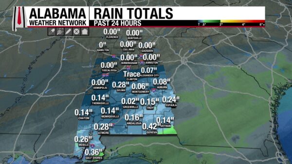
Rainfall was mainly limited to South Alabama on Saturday, with the heaviest amounts across parts of Baldwin, Geneva and Houston Counties. The winner was 0.42 inches at Geneva in Geneva County. Selma picked up 0.28 inches.
NORTHEAST EARLY-SEASON RECORD COLD
An early December blast delivered true mid-winter intensity across the Northeast, dropping temperatures to levels rarely seen this early in the season. Saranac Lake led the way at 22 below, breaking a record more than twenty years old. Montpelier and Plattsburgh also set new marks as the Arctic air settled in.
Saranac Lake, NY — -22° (old record -20° in 2003)
Montpelier, VT — -8° (old record -7° in 1971)
Plattsburgh, NY — -4° (old record 0° in 1971)
WINTER STORM LIFTS INTO THE GREAT LAKES
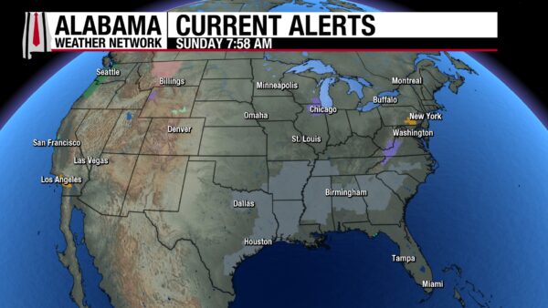
A departing low continues to spread light to moderate snow from the Lower Great Lakes into parts of the Northeast today, following last night’s heavier snow in the Upper and Middle Mississippi Valley. Additional light snow may linger into tonight as the system pulls toward eastern Canada.
SOGGY SOUTHEAST WITH RAIN AND A FEW STORMS
Rain continues across portions of the Southeast today as moisture lifts northward. Light to moderate rain stretches from Alabama and Georgia into the Carolinas, while the Florida Peninsula sees scattered showers and thunderstorms. Rain gradually tapers from west to east tonight.
PACIFIC NORTHWEST WELCOMES HEAVY RAIN
Onshore Pacific flow keeps steady coastal rain and mountain snow going today across Washington and Oregon. A richer plume of moisture moves in on Monday, supporting a Slight Risk for excessive rainfall and the potential for localized flash flooding in urban areas, along small streams, and in low-lying spots.
NORTHERN ROCKIES HOLD ONTO LIGHT SNOW
Upper-level energy continues producing occasional light to moderate snow today across the Northern Cascades, Northern Intermountain Region, and Northern Rockies. Another disturbance dropping out of the Northern Plains brings light snow to the Upper Great Lakes late tonight into Monday.
BEACH FORECAST
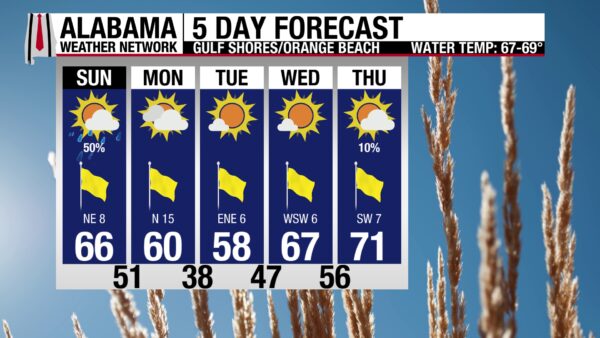
It’s a mostly cloudy but comfortable Sunday along the Gulf, with highs in the mid 60s and a few light showers drifting through from time to time. Surf sits around 1 to 2 feet with water temperatures near 60 degrees, and today’s rip current risk ranges from low along Alabama beaches to moderate across the Florida Panhandle. It’s a decent day for a mellow stroll along the shoreline, though swimmers should stay mindful of currents near piers and jetties.
Looking ahead, a strong cold front arrives Monday, bringing brisk north winds and a noticeable cool-down. Surf rises to 1 to 3 feet and rip current risks increase, especially along the Florida beaches, before gradually easing midweek. Sunshine returns Tuesday and Wednesday with highs in the upper 50s to mid 60s, lighter winds, and calmer Gulf waters. By Thursday, a gentle warming trend makes for another inviting beach day with bright skies and surf mostly around a foot.
TODAY IN WEATHER HISTORY
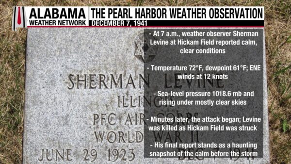
December 7, 1941 — Pearl Harbor Weather
At 7:00 a.m. on December 7, 1941, just before the surprise Japanese attack on Pearl Harbor, weather observer Sherman Levine at Hickam Field in Honolulu recorded calm and pleasant conditions. The sky was mostly clear with only a few cumulus clouds and no obstructions to visibility. Sea level pressure was 1018.6 millibars with an altimeter setting of 30.08 inches and rising. The temperature was 72 degrees with a dewpoint of 61 degrees, and winds were from the east-northeast at 12 knots.
It was a peaceful morning by all meteorological accounts — an ordinary start to what became one of the most pivotal days in American history. Tragically, Sherman Levine was among those killed in the attack later that morning. His final observation remains a haunting snapshot of the calm before the storm.
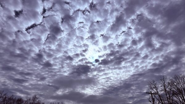
IMAGE OF THE DAY
Skywatcher Daniel Harbin captured a beautiful buttermilk sky over Scottsboro as the clearing began over North Alabama on Saturday.



