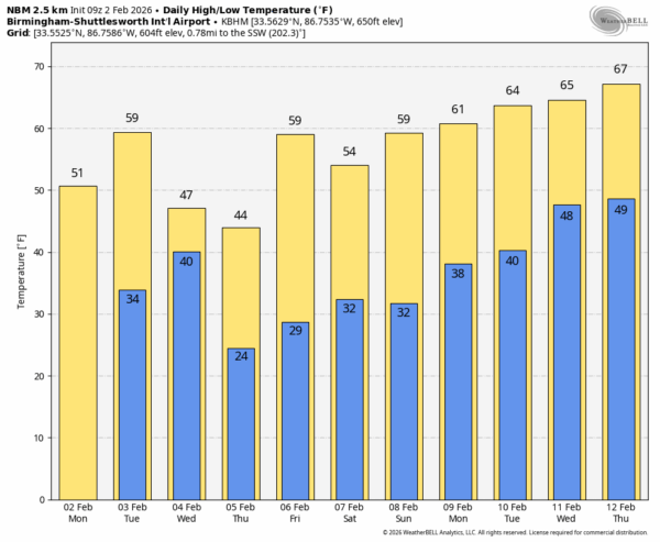
WARMER DAYS: While temperatures are in the teens and 20s across Alabama again this morning, expect a nice warm-up today with highs in the 50s for most communities along with a sunny sky. Temperatures will reach the 60s across the southern counties of the state tomorrow as the warming trend continues.
Clouds will increase tomorrow ahead of a cold front, and rain is likely tomorrow afternoon, tomorrow night, and into Wednesday morning. No lightning/thunder, and most places will see rain amounts around 1/2 inch. Colder air follows the rain Wednesday as highs drop back into the 40s and 50s.
Thursday will be sunny but cold; after a morning low in the 20s, the afternoon high will be in the 42-52 degree range across the state. Friday will be warmer with highs in the 50s and 60s.
THE ALABAMA WEEKEND: For the first time in several weeks we can advertise a weekend of calm weather for Alabama and the Deep South. The sky will be sunny both days with highs in the 50s and 60s.
NEXT WEEK: It will feel more like spring next week as the trend toward warmer weather continues. Highs will be mostly in the 60s; the southern counties will likely enjoy a high in the low 70s over the latter half of the week. Some scattered rain is possible during the middle of the week, but nothing really heavy. And, we see no signs of any snow/ice issues for the Deep South for at least the next 10-15 days. See the video briefing for maps, graphics, and more details.
ON THIS DATE IN 2016: Four tornadoes touched down across West Alabama, including an EF-2 in Pickens County. Heaviest damage was in the Sapp community where one person was injured.
Look for the next video briefing here by 3:00 this afternoon… enjoy the day!