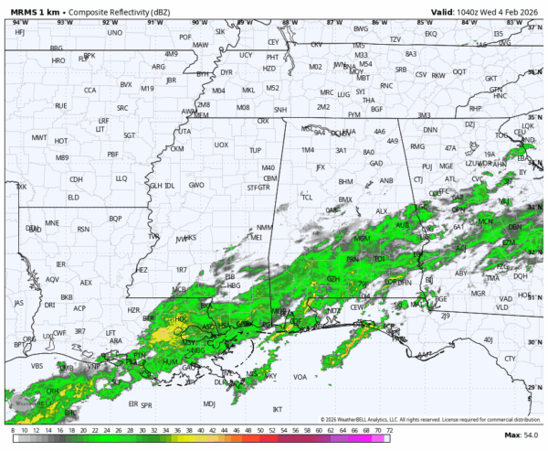
RADAR CHECK: A large mass of rain covers the southern half of Alabama early this morning; it will end later today. Clouds will linger across most of the state through the day, although some clearing is possible over the southern counties this afternoon. Temperatures won’t rise much today, with most communities holding in the 40s and low 50s.
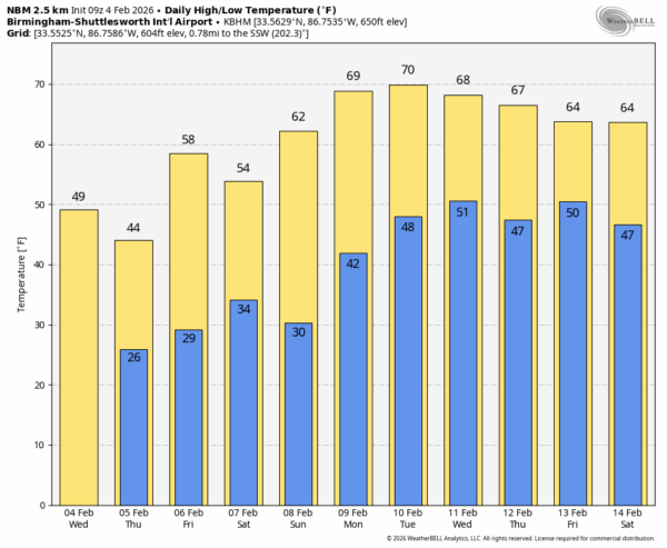
Tonight will be mostly clear and cold; lows will be in the 20s for the northern 2/3 of the state by early tomorrow morning, lows 30s are likely for the far southern counties. Tomorrow will be sunny with highs in the 40s and 50s.
FRIDAY AND THE WEEKEND: Dry weather continues with mostly sunny pleasant days and fair chilly nights. Highs will be in the 50s and 60s, lows will be in the upper 20s and 30s. For a change we won’t be dealing with snow, ice, thunderstorms, or tornadoes this weekend.
NEXT WEEK: The weather will be unseasonably mild with highs in the 60s and 70s; a nice preview of spring. A few sprinkles are possible at mid-week, global models suggest the next meaningful chance of rain comes late in the week, and possibly into the following weekend. See the video briefing for maps, graphics, and more details.
ON THIS DATE IN 1971: A series of tornadoes tore through parts of Alabama and Mississippi. In Alabama, one person was killed in Bear Creek when an F3 tornado moved through; it was down for a little over three miles through Marion County. In Mississippi, seven members of one family were killed by a tornado in Grenada County. They were all in a mobile home.
ON THIS DATE IN 2011: A winter storm settled four to six inches of snow over northern Texas, including Dallas, just days before the Super Bowl between the Pittsburg Steelers and the Green Bay Packers.
Look for the next video briefing here by 3:00 this afternoon… enjoy the day!