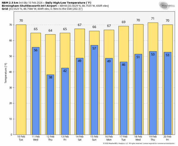
SPRING-LIKE PATTERN: Expect a high today in the 68-74 degree range across most of Alabama with a mix of sun and clouds after some dense fog early this morning. Clouds will thicken this evening, and a disturbance will bring a few periods of rain late tonight into tomorrow morning. The main window for showers will come from about 10:00 tonight through 10:00 tomorrow morning; rain amounts will be 1/2 inch or less for most places.
Some clearing is possible tomorrow afternoon; the high will be in the 60s.
Thursday and Friday are looking dry and pleasant with highs generally in the 60s; some South Alabama communities could touch 70 degrees.
WET WEEKEND: A dynamic system will bring a soaking rain to Alabama and the Deep South this weekend. Most of the rain will come Saturday night and Sunday, although a few showers could ease into the western counties during the day Saturday. Rain amounts of 1-2 inches are likely, some spots could see more.
Global models suggest the surface low will move through South Alabama, and the air will be relatively stable, meaning there the risk of severe storms looks low at this point. But a few thunderstorms are certainly possible, if not likely. Highs will remain in the 60s over the weekend.
NEXT WEEK: At this point much of next week looks dry, although a few isolated showers are possible around mid-week on Wednesday. Spring-like weather continues with highs in the upper 60s and low 70s. See the video briefing for maps, graphics, and more details.
ON THIS DATE IN 1959: St. Louis, Missouri, was hit by a massive F4 tornado that killed 21 and injured 345. Over 2000 buildings were damaged or destroyed, including the St. Louis Arena.
ON THIS DATE IN 1981: A morning tornado at Bay Minette struck the local middle school severely damaging the gymnasium. The tornado hurt 62 people were injured, 44 of whom were students.
ON THIS DATE IN 2013: A large multiple-vortex EF-4 tornado devastated the cities of West Hattiesburg, Hattiesburg, and Petal, Mississippi. The tornado was one of eight that touched down in southern Mississippi and southwestern Alabama that day. It reached a maximum path width of 0.75 miles in its path through the Hattiesburg area and reached estimated maximum sustained winds of 170 mph in the Oak Grove neighborhood of West Hattiesburg. It destroyed many structures and impacted University of Southern Mississippi and two high schools. Two EF1 tornadoes touched down across Washington and Clarke Counties in Alabama. These tornadoes removed roofs from homes, severely damaged a few mobile homes, and downed many trees, including numerous pine trees that were snapped.
Look for the next video briefing here by 3:00 this afternoon… enjoy the day!